The Chimney Hollow/Elliott Knob shuttle hike is the big brother of the Elliott Knob out and back route. At 15.4 miles and over 3,600 feet in altitude gain, this day hike is a serious workout. With great vistas, as well as nice stream walks, the hard workout is well worth the effort.
However, if that's a little more than your willing to do, you can also start at VA688 and make this a 9.4ml 2,700ft shuttle hike.
Mile 0.0 – From the parking area on U.S. 250 walk 50 yards to the trailhead of the yellow blazed Chimney Hollow Trail, then cross a small foot bridge built a local boy scout troop. Continue along the Chimney Hollow stream as it gradually begins to climb more steeply up the hollow then arrives at the first good viewpoint of Shenandoah Mountain. This vista spot is located just below Coalpit Knob.
Mile 1.7 - Continue along the Chimney Hollow Trail with the Crawford Mountain ridge visible directly ahead. At 3.2 miles the trail makes a share turn back to the left and climbs the remaining 0.2 miles to the Crawford Mountain Trail intersection and ridgeline.
Mile 3.3 - Turn right south along the yellow blazed Crawford Mountain Trail as the first couple of miles are a gradual decline, then the trail descends much more steeply for the next 1.6 miles down to Dry Branch Gap.
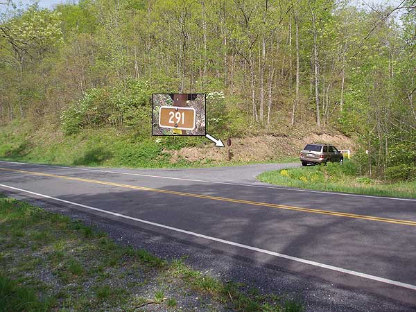
Mile 5.5 - Pass a closed gate at Dry Branch Gap, and cross VA688 onto the yellow blazed Elliott Knob Trail. Pass another gate as the trail starts up towards Lead-off Ridge on Great North Mountain. In 1.8 miles pass a side trail that goes down to Buffalo Spring. The spring is no longer flowing reliably. From the Buffalo Spring side trail it's a further 0.8 miles on the Elliott Knob Trail to the ridgeline.
Mile 8.1 - Continue to follow the Elliott Knob Trail for 1.6 miles where the trail ends at the Elliott Knob fire road.
Mile 9.7 - Turn right uphill on the fire road for 0.2 miles passing through a pine stand. From here the Elliott Knob Lookout Trail heads around the west side of the mountain then in 0.2 miles reach the Elliott Knob summit and fire tower. Enjoy the beautiful 270° panorama!
Mile 10.1 - From the summit retrace your steps back down the fire road and pass the Elliott Knob Trail you ascended earlier. Continue down the fire road another 2.0 miles at which point the yellow blazed Falls Hollow Trail enters from the left.
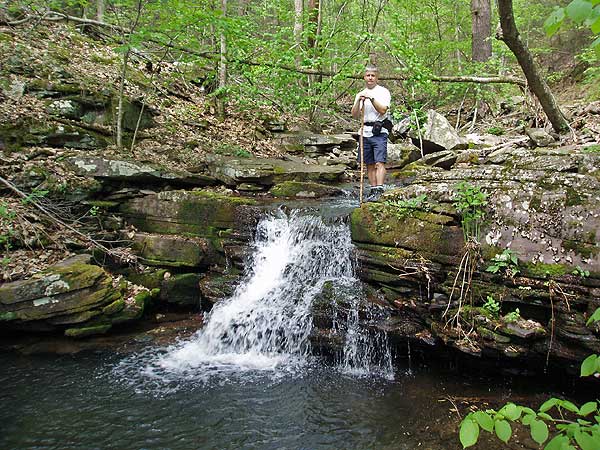
Mile 12.4 - Turn left onto the Falls Hollow Trail and follow it for 0.8 miles to the creek where the trail makes a sharp right downhill.
Mile 13.2 - Continue downstream on the Falls Hollow Trail passing several small waterfalls. The trail then becomes wider joining an old logging road. Continue along the logging road for another 1.0 miles where the Falls Hollow Trail ends at the parking area on VA42
If this is the big brother to the Elliot knob out and back, I did the step-sister hike which is to start and end at 250.
I was told to wear pants and I did, however the trail appeared to have been weeded recently. Within the first 2 miles I saw one tiny tiny tiny bear cub. It was so tiny and he/she scurried up a tree and made its way out onto a small little limb. I didn't stick around too long just cause. The rest of the hike was pretty mellow with not a lot to see. The tower was neat and so I had lunch there and scouted out the campsites. The second half of the hike was ok. It felt steep at times due to the tired legs, but it wasn't a killer.
The best thing about this hike is that it was the second hike this year that I didn't have sopping wet feet from rains or flooded streams.
By:Trewbie
Rating:
Date of Hike: Saturday, May 21, 2016
A group of us hiked here this past weekend. It rained most of the time and it was a pretty brutal hike, so be in decent shape if you are planning this hike. We hiked up to Elliots Knob the first night and then back down the fire road and out to the car the next day. There was a nice flat area near the watchtower which made for a nice place to pitch tents. There is also a large area of rocks that worked well for us to cook our food (we all brought personal mini stoves).
As far as water, there is a small stream once you come to fire road however after hiking all day going up that fire road and up the last little hill almost did most of us in. There is water available, but you should have a gps or something to show you where because it was right over a small mound and into the woods maybe 50 feet. (The leader of the group had his own GPS and knew where it was located.) So being plenty of water because there is nothing at the top of the hill in regards to a water source.
On the trip back down it was lovely to see the water falls, and we did have to cross multiple streams so expect to wear quick drying clothes and bring extra socks as all of our shoes and socks were soaked from crossing in some parts there was no "dry" way across.


