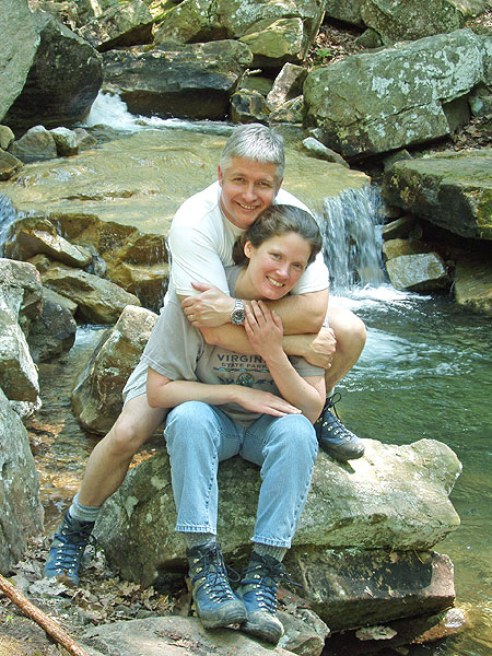
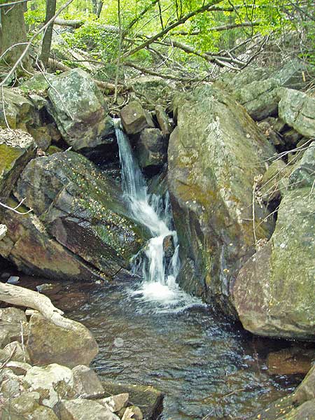
Morgan Run, on the southern end of the Massanutten mountain range, passes the wonderful Fridley Gap swimming hole that is also accessible on the Fridley Gap Hike. Mountain streams and waterfalls are at every turn on the Morgan Run section of this secluded loop hike.
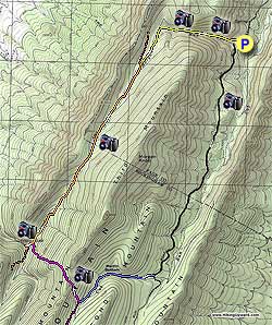
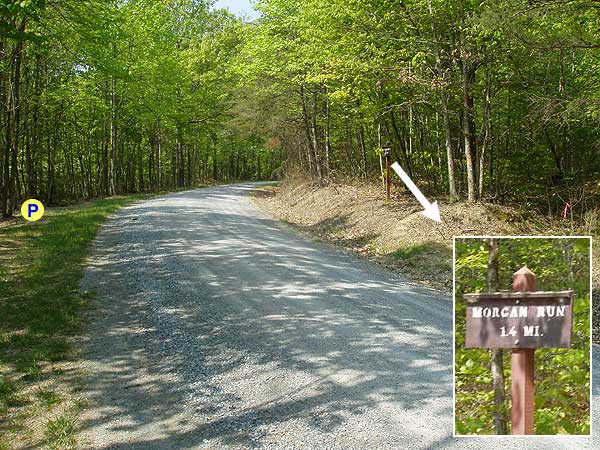
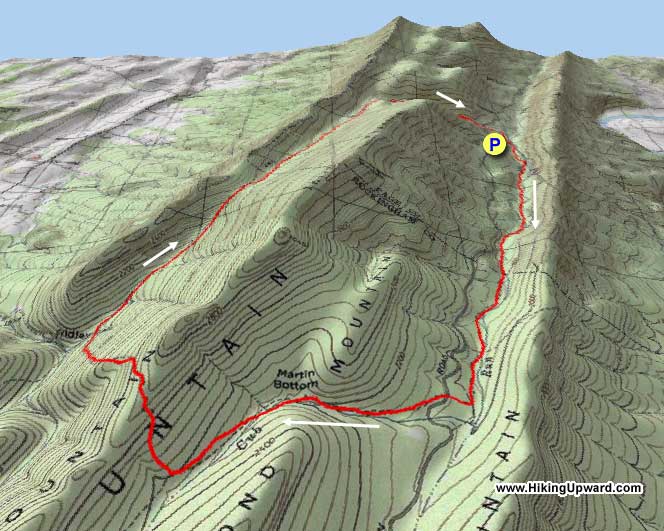
After parking, continue walking along the Cub Run gravel forestry road as it gently ascends the valley. This forestry road is not heavily traveled, however, keep an ear out as one or two vehicles may pass by before you reach the intersection of the Martin Bottom Trail 3.0 miles from where you parked.
Turn right up the blue blazed Martin Bottom trail as it climbs through the pass before arriving at the purple blazed Fridley Gap Trail. The blue blazes of the Martin Bottom Trail end, and at this point the trail continues as the purple blazed Fridley Gap Trail.
Turn right uphill on the purple blazed Fridley Gap Trail for the steepest portion of the hike as it climbs Third Mountain, crosses the ridge, then very steeply descends to the intersection of the orange blazed South Trail.
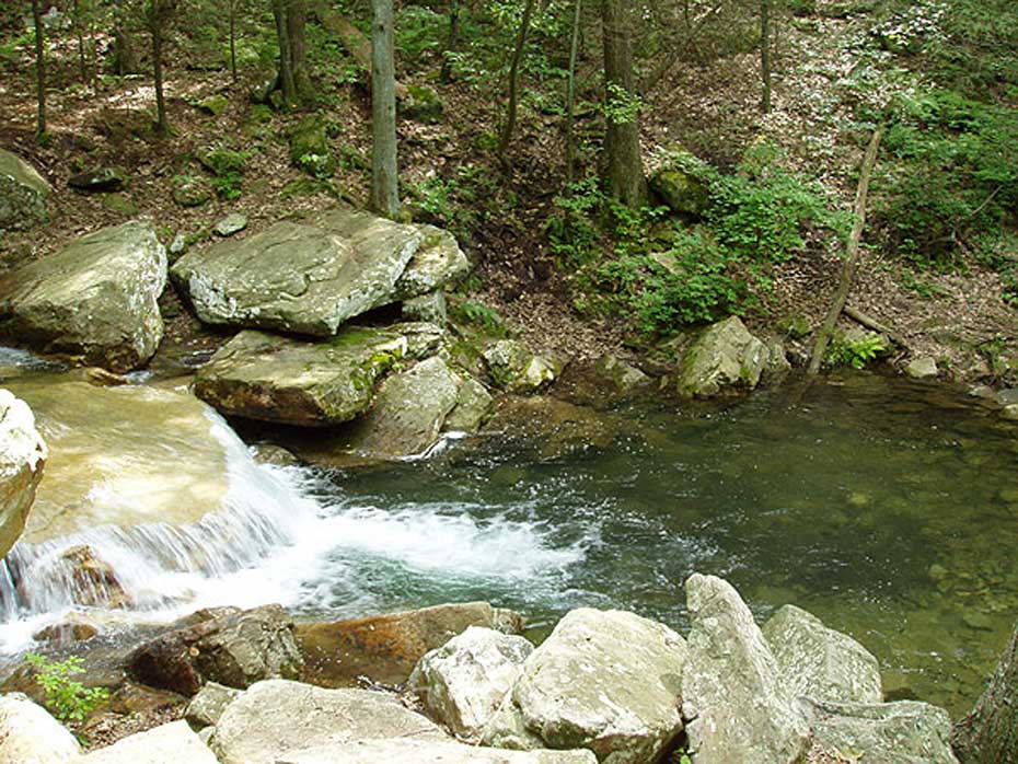
Turn left downhill for 150 yards, then turn right at the post, cross a small run and in 75 yards the Fridley Gap swimming hole will be on your left. This is an excellent place for lunch and a swim in the late summer.
To continue, retrace your steps back over the run, turn left up the orange blazed South Trail, again passing the purple blazed Fridley Gap Trail descended earlier. Continue on the orange blazed trail for 2.8 miles as it crosses Morgan Run several times, cresting the high point then gradually descending and meeting the intersection of the yellow blazed Morgan Run Trail on your right.
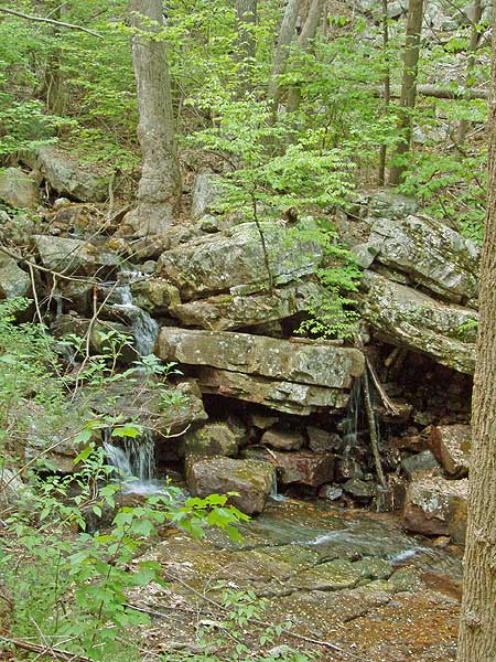
Turn right on the narrower yellow blazed Morgan Run Trail which in 200 yards meets Morgan Run then descends through the gap. The trail is rocky in places as it crosses back and forth across the run, passing small waterfalls and old growth forest. 1.2 miles after joining the yellow blazed Morgan Run Trail pass a campsite on your right and emerge onto the forestry road returning to the parking area.
Mid May
Fridley Gap Swimming Hole
Morgan Run Hike Comments
Archived Comments
By:Dave
Rating:
Date of Hike: Saturday, March 30, 2019
Would agree with many of prior comments. Swimming hole area was very pretty and there is well established campsite that will hold several tents. We did run into some locals who said the site is popular. I really enjoyed the Morgan Run portion, probably because it was so crazy, but the first half was mostly underwater or deep mud and the second half was pretty treacherous rocks and steam crossings (at least treacherous with 40-lb pack on my back). Ran into other locals who called it "the gorge," which sounded accurate to me. Couldn't ask for more beautiful, classic Shenandoah scenery, though.
By:JR
Rating:
Date of Hike: Sunday, November 6, 2016
A great fall weather hike did it for the first time and really enjoyed it. We would not rate as a LVL '3' hike would rate a bit higher considering the challenge of the downward rock-bound climbs. Great variety of terrain- including the rock sections, and not very crowded. Would recommend doing the hike in dryer conditions, as even with the lack of rain that we have had for a while, there were still some moist areas that we would imagine would be swampy in damp conditions. We were able to take the dog, but- again be ready to control the beast over the rocky sections. We will definitely do it again. Rating a bit lower, as some trail maintenance is probably needed on the upper part of Morgan Run and some areas of Fridley.
By:Suzanne M.
Rating:
Date of Hike: Wednesday, March 30, 2016
So first of all, "props" to the person who blogged earlier about this and said it was "easy".... ummm not so easy. There was a predominant theme of the day: rocks, and more rocks. Even the "gradual decent down" was full of rocky footing. There was one spot with great views, the swimming hole area was lovely and we did manage to finish in 5 hours. The "rocky area" in the final mile was rather tricky to navigate, and possibly trickier b/c we had two pups with us. The footing was quite technical at times, sure seemed more like a 4 rating than a 3. Glad to have conquered Morgan's run! Challenging and fun day over all.
By:THD
Rating:
Date of Hike: Saturday, May 9, 2015
I did this hike with my husband and our dog and completed it in one day. I am ranking this as a two stars because it wasn't close at all to my expectations. Perhaps if it was ranked (maybe a 4?) and described differently, I would give it a better ranking because it was do-able. So read on below and maybe its the hike for you! The accents and descents were fine for us. Despite being a little boring, starting on the forest road wasn't a big deal since I much prefer circuit hikes. The Martin Bottom and Fridley's Gap trail sections were fine too. I'd like to come back to the swimming hole when its warmer out. And I'd likely try out another route to get there. The swimming hole was a good spot to eat our lunches. The rest of the hike was very wet, soggy, and technical. The South Trail had water flowing across and in/with it many times, and most of it was just soggy where your foot sank an inch with every step, and if it wasn't wet the trail itself had lots of cobbles that made walking not that great. The Morgan Run Trail starts a little narrow, but it wasn't bad this time of year. I don't think we'd been able to walk it very well later in the season with growth extending into the trail. Then we moved into very wet sections of the trail, where it was pretty swampy under water in multiple sections. Thankfully, someone had placed sections of logs down perpendicular to the trail for people to walk across and I would consider this too technical to be ranked a "3". It appears that the Morgan Run trail had experienced severe flooding at some point. The last mile or so became difficult to find/ follow the trail. We were stopping frequently to look around for yellow blazes. At one point there was a yellow blaze on the opposite bank, but I could see it continue a few hundred feet down on my side and it looked more difficult to cross the stream than it was to just follow the same side of the stream. This section is also technical with the constant rock scrambles and the multiple river crossings. Hard on the knees. The small waterfalls were pretty. However, I wouldn't hike this route again.
By:moondrunk
Rating:
Date of Hike: Friday, July 4, 2014
The swimming hole was great, and the last section of the hike on the Morgan Run Trail was quite pretty and enjoyable (though be forewarned: it is a river of large rocks for most of the way, and extremely swampy wherever it wasn't rocky). The rest of the hike was pretty unremarkable, and the South Trail was extremely overgrown, with no redeeming features. While the trail is still easily discernible (seems to be an old logging road), a machete would not have been unwelcome. This part of the hike was just a long slog that felt like it would never end. I would probably not do this hike again, though I would consider trying the Fridley Gap hike, as the swimming hole is definitely worth a re-visit.
By:Bill
Rating:
Date of Hike: Saturday, May 17, 2014
Made this an overnight backpacking trip. Recent controlled burn activity in the area (from early May) affects parts of this hike now. Still easily passable but fire damage is highly noticeable and distracting in sections. The hiking and camping are first rate though. The first ascent is a little strenuous but not long. Camping near the intersection of the South Trail was great. The sound of waterfalls is the best kind of white noise! Overall a nice hike - except for the signs of fire.
By:Mike
Rating:
Date of Hike: Saturday, February 23, 2013
We hiked this route as described over two days. Overall a great hike! Three miles down the road was a bit of a boring start, but the climb over the ridgeline and dropping down into the valley below made up for it. We camped just beyond the confluence of the two creeks (50 yards south). There was ample room for two tents without encroaching on the fire ring.
The hike out was fabulous. The varying terrain will definitely keep you on your toes. I'm looking forward to hiking this again in the summer to take advantage of the swimming hole.
By:Vawallflower
Rating:
Date of Hike: Monday, June 25, 2012
My dog and I did this as a two day. Started at Morgan Run so got the pretty stuff first. That would have been nice to do at the end instead of fire road but all was good. Beautiful scenery, loved the sound of the water through most of the hike. Not many camping spots. Saw several deer and hawks and heard lots of critters at night. Bear scat on the trail but didnt see any bear. I did not see another person for two days. It was great. Only downside is the lack of campsites. The one that I did see had trash and beer cans and bottles in the fire ring. :-(
By:Andy N
Rating:
Date of Hike: Saturday, July 10, 2010
Overall awesome hike, pool, and campsite. We had a hard time finding the first parking location and ended up parking at the start of the blue blazed trail and skipping the road walk. The hike to the swimming hole was good - not much in the way of views, but it was a workout. Be careful on the descent - it is pretty steep with loose rocks at times. The swimming hole was great, as was the campsite right next to it. Overall it was pretty secluded - three groups of people passed by to swim over the course of a day.
We had two dogs with us and the hike wasn't a problem for them.
By:Keith Lehman
Rating:
Date of Hike: Thursday, July 1, 2010
I did this hike as described as an overnight trip on two beautiful days. The road walking was fine as I did it before noon and it was well shaded. Only two cars were seen. Met a day hiker at the trailhead of Martin Bottom Trail but otherwise was alone until I got to the swimming hole. Martin Bottom is a fire road and there has been a burn of some sort on the left that left it a bit exposed to the sun. Not bad but August may be hot in this section. The Fridley Gap trail was steep going up but no crawling was required. There was no view this time of year at the peak but after leaf fall it might be nice. The down hill section was a bit dicey as you are in a streambed with a lot of loose rocks. Still doable by the average hiker though.
The swimming hole was fantastic and a great (cold) relief. There is a fire ring and room for maybe one tent at the Y above the swimming hole but literally right above the swimming hole is a fantastic site that could accommodate a couple larger tents. Even on this Thursday night there were several groups moving through the area. I think I'd bump the Solitude score down a peg or two as the weekends are probably busier. Interestingly, there is some cellular signal down in this hollow so you can at least get a text out if needed (5 bars just up the hill).
The hike out was typical for the region with a mix of single track and old logging road. The South Trail is a little hard to follow but mostly well marked. The overgrowth was pretty bad with ferns and pointy things. By late July you may need a machete. Someone send a pack of Boy Scouts through to whack some bushes please! The Morgan Run Trail is very rocky and hard on the knees if you have a heavy pack. It's the most beautiful part of the trip though with a lot of little waterfalls.
The first half of the trip (car to swimming hole) is almost devoid of water. The second half follows streams so there is little need for extra water unless there is a serious drought. Tree cover is 80-90% for much of the trip so it's a good one to do if it's hot and sunny. The swimming will definitely help you refresh yourself. if it's hot.


