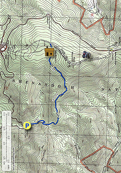
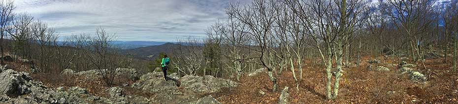
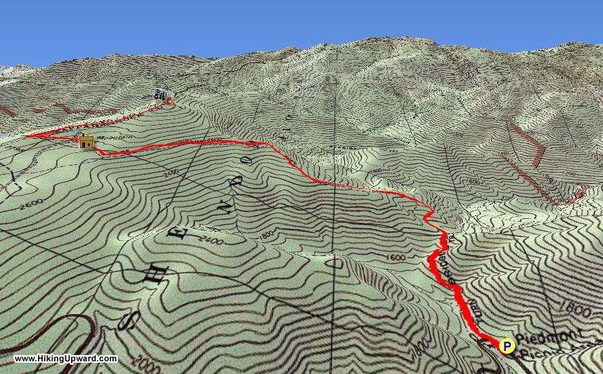
With such diverse scenery, it's surprising the Pass Mountain Trail is one of the least used in the central Shenandoah National Park. With a pleasant forest walk along the ridge, and nice views of Mary's Rock, the trail ends at the Pass Mountain Shelter. From there it's a short walk along the AT over the summit of Pass Mountain down to Double Bear Rocks with beautiful views westward of New Market Gap, Luray, and Strickler Knob. Double Bear Rocks is another hidden SNP vista not many visit.
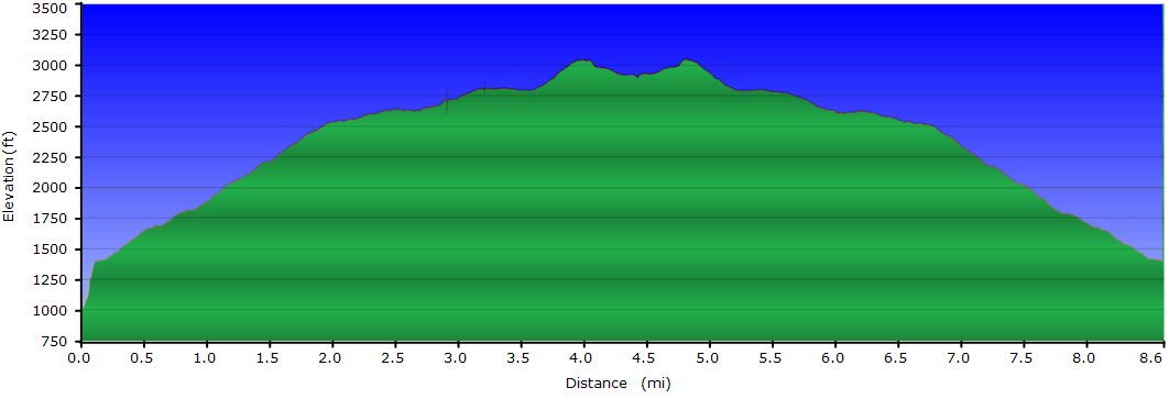
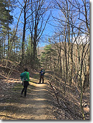
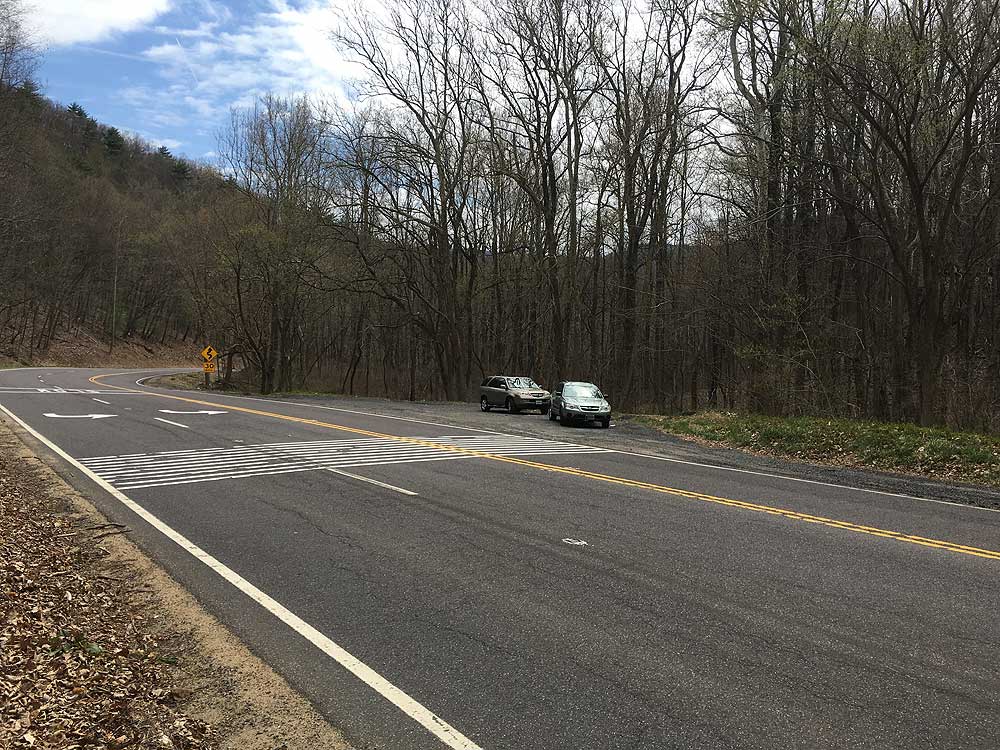
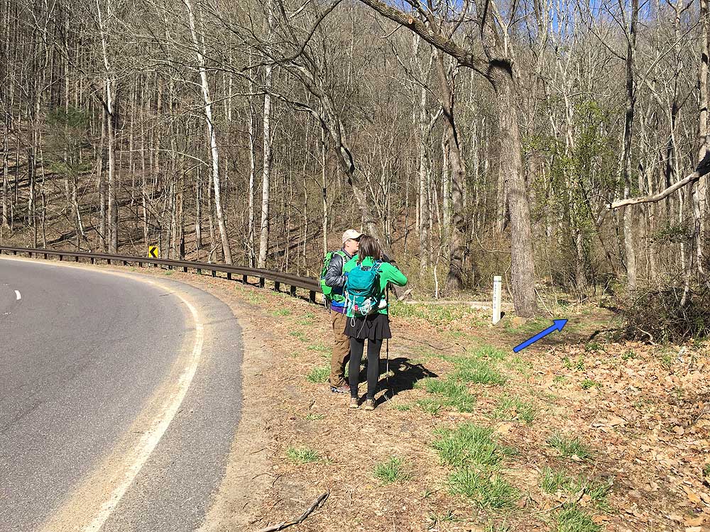
Mile 0.0 - From the parking area on VA211 CARFULLY cross the road and start the hike at the Pass Mountain Trail marker from the hairpin turn on VA211. The blue blazed trail heads uphill and gradually becomes steeper and making 2 hard switch backs before arriving at the ridge and old trail post for the now abandoned fire road trail in 0.9 miles.
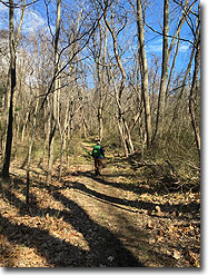
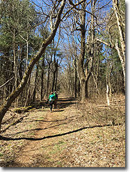
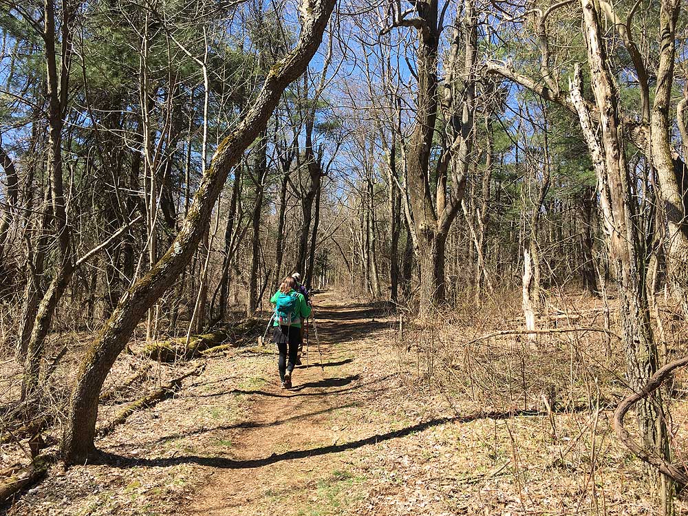
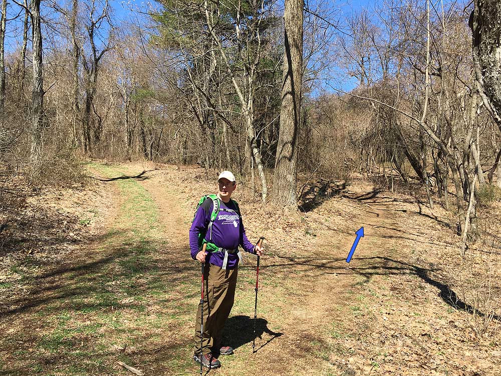
Mile 0.9 - Stay left continuing on the blue blazed Pass Mountain Trail as it follows the ridge. There are several good views of Mary's Rock on the other side of Thornton River through the trees. At 1.9 miles the trail turns left and levels out for 0.7 miles, turns right, then climbs to the Pass Mountain Shelter.
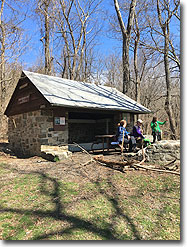
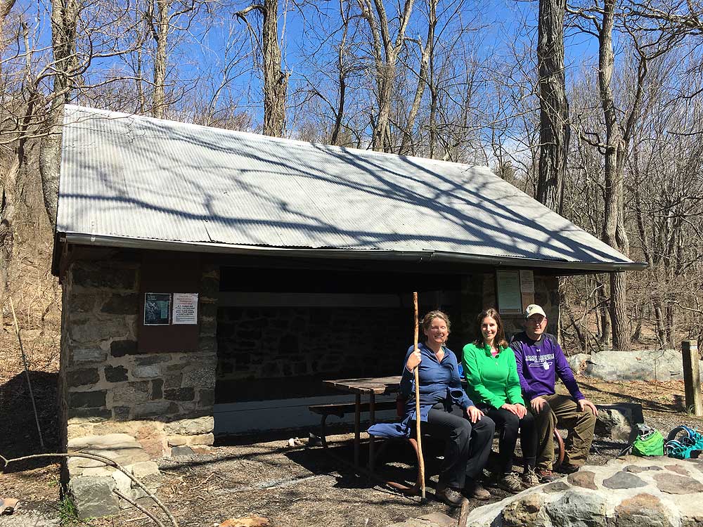
Mile 2.8 - The Pass Mountain Shelter has both a high and low bunk with 2 outhouses. Several years ago a nuisance bear in the area had to be transported to another section of the SNP and after that incident steel bear boxes have been installed. There are 2 side trails on the right of the shelter, one leads to a spring, and the other to a tent camp area. From the shelter an access road splits to the left, stay right uphill on the blue connector trail then in 0.25 arrive at the intersection of the Appalachian Trail (AT).
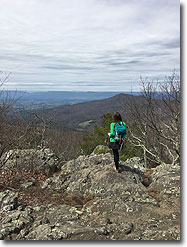
Mile 3.72 - Descend the summit of Pass Mountain and follow the AT for another 0.53 miles to Double Bear Rocks overlook. There is no signage marking the overlook, look for a side trial on the left of the AT that leads 25 yards down to Double Bear Rocks.
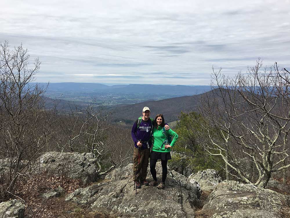
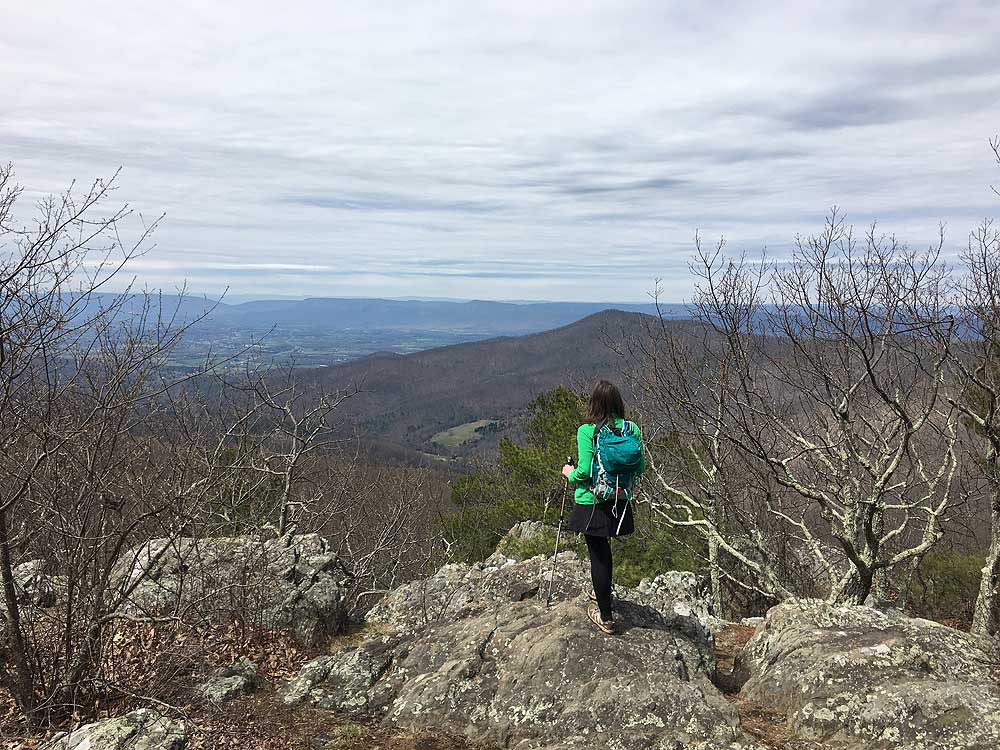
Mile 4.25 - At Double Bear Rocks there are expansive views west of the Luray Valley, New Market Gap, and Massanutten Range, with Strickler Knob and Kennedy Peak visible on a clear day. Retrace your route back to the parking area.
Mile 8.5 - Arrive back at the parking area on VA211.
Mid April
Double Bear Rocks Hike Comments
Archived Comments
By:bushWhacker
Rating:
Date of Hike: Sunday, September 22, 2019
Trail looks like it has not been used much this summer. Entrance is way overgrown (when you walk out of the parking lot cross 211 and "turn left" towards the hairpin turn, look for a trail post on your right before the guardrail starts). The flat section of the hike before you get to the shelter is also very overgrown with grass, recommend pants and bug spray for sure. Went with 4 people and a dog, no ticks found after. Everything after the shelter is beautifully maintained, the view is easy to miss but quite lovely.
Other random notes:
-Lots of bear scat around
-Shelter in good shape, as is it's outhouse
-Lots of butterflies
-Lots of spiderwebs on the trail
My family likes a well groomed trail so this wasn't the best choice for them, but if you like a little adventure and seclusion this is a good one.
By:nort
Rating:
Date of Hike: Saturday, December 16, 2017
Nice hike, not very strenuous. I thought there might be better views with all the leaves down, but aside from the overlook there really weren't many/any views at all. It's a nice walk in the woods, though, and there were a couple inches of snow blanketing the north side of Pass Mt. The spring at the hut was just a trickle but it was running.
By:AA
Rating:
Date of Hike: Monday, May 29, 2017
Steady uphill almost the entire way to the top, though it was not a terribly strenuous grade. There wasn't much as far as scenery to look at other than the woods, which is always nice. We went slowly though steadily and it took us about 4 hours to get to Double Bear Rocks. The view was minimal from the rock outcropping, but a nice place to sit for a bit and have a snack nonetheless. There was gorgeous pink mountain laurel blooming that was a special treat. The way back was almost entirely downhill other than a short section upward close to the outcropping and took about 2.5 hours. We saw a small orange salamander and a few flowers but not much else. Our fitbits all said 10 miles (plus some) by the time it was said and done, so we were questioning if the mileage listed on this is accurate, but who knows- those are not always accurate themselves.
By:Steve
Rating:
Date of Hike: Monday, May 15, 2017
I read the reviews from 2016, generally, agree, and won't repeat all the points. I think I liked the hike a bit more. This is one of the smoothest, nicest-on-the-feet hikes I've been on in the park. I'd say over 80% of the trail is packed dirt or gravel, smooth except for quite a few roots, a few of which I stumbled over (their appearance kind of blends in with the soil) -- just watch and you'll be OK. The overlook at Double Bear Rocks was quite nice to me -- I could see Kennedy Peak. Was a bit disappointed there was no view to speak of from the top of Pass Mountain (at least from the trail). Virginia State Police were very active enforcing traffic along Rt. 211 including near the trailhead -- they were pulling one car after another into the hike parking area, I think for going over the lowered speed limits on the curves. I advise strictly observing the speed limits along Rt. 211 and as you approach the parking area.
By:The Wanderer
Rating:
Date of Hike: Thursday, October 20, 2016
I did this hike for my own in October 2016 and I plan to do this hike again this autumn. It was a sunny day in October but I didn't meet any person on the complete hike. I took a ratch with me because of black bears. I used the ratch from time to time on my way uphill and I didn't meet anybody nor a human nor a black bear. It was very lonely there. On my way downhill I missed to use my ratch on the last mile or a little bit more. Suddenly two younger black bears crossed the footpath 30 meters in front of me on their way downhill. 200 - 300 meters later I saw another black bear more far away in the glen.
By:VSOP
Rating:
Date of Hike: Saturday, July 2, 2016
With the great weather for the beginning of the 4th of July weekend and needing to get out on a training hike I did this hike. I hadn't been out in a while so the length and profile were good for a start. And I wanted to try something new. This is a good hike if you don't want to be out all day. One thing I'd add to the directions is that the pull off on Rt 211 is the second one on the left, and the smaller of the two, if you are coming from the East. It's about 45 yards short of the trail head which is on the westbound side of the road on the outside of the hairpin turn. The trail is pretty well maintained and uses some narrow fire roads in places. There aren't any spectacular views until you get to Double Bear Rocks overlook. The grade is about right to stretch out and is pretty much straight up after some early switchbacks. Fthe first trail intersection marker upward to Pass Mt Hut, there's FRESH bear sign all the way. In the trail and just off it. Scat and overturned rocks. I spooked something off the trail on the way up but couldn't see what it was. I stopped and it stopped and it bolted when I took a few more steps. There were two springs along the way to the hut that were running well. It took me 90min at what I'd consider a leisurely pace to get to the hut. The Pass Mt Hut spring was running good. Shelter was swept clean. There seems to be ample area for tent camping to the right and left of the shelter. It has two latrines of which one is a composter. Probably a good thing if you get the stomach bug advertised on the poster at the shelter. Sure beats NO latrines in TN!
By:Threehikers
Rating:
Date of Hike: Saturday, June 25, 2016
A nice hike with uphill going out and downhill on the return. The trailhead requires careful road crossing to avoid traffic that is moving at some speed coming down the mountain, being across the road and uphill from the parking area. We ran into a couple of blowdown S from the recent storms but you can get across them if careful. The new privy at Pass Mountain hut is first class! The AT once you are past the hut is a slight climb and once you cross the summit it is downhill until the side trail to the rocks. The vegetation has grown up so the views were limited and our day featured low clouds also. A nice walk in the woods with varied forests and good trail conditions.
By:Nate
Rating:
Date of Hike: Sunday, May 29, 2016
This is a really nice walk in the woods, and is apparently a lesser known trail so the solitude was pretty good. I only ran into a few other hikers and one bear. I would highly dispute the rating of "4" for views. The one overlook is nice, but not great. Be careful on the Pass Mountain trail as it is a bit overgrown so there are lots of opportunities for ticks to latch on. The main highlight of this hike for me was being able to observe a black bear, which you can see here: https://www.youtube.com/watch?v=SasjuOxs2rs
By:Greg
Rating:
Date of Hike: Friday, May 13, 2016
My fianc�e and I enjoyed doing this hike in mid-May. If you're driving east on 211 from Luray and the gravel parking area is on your right, then the trailhead is behind you, across the road. As other reviewers noted, the first stretch is a steady incline, but it does get easier. The trail was narrow in spots, but well-marked and comfortable -- often just dirt or pine needles, rather than loose rocks. We a saw a black bear moving away from us near the creek crossing, plus a crazy amount of long black millipedes along the trail, and there were some friendly campers and AT hikers at the shelter. The overlook at the turnaround point is decent. I'd say the best things about this hike were the solitude and the lush scenery.
By:aldikuma
Rating:
Date of Hike: Wednesday, April 20, 2016
Nice, easier hike. The views are not as spectacular as other parts of SNP, but still beautiful with the rocks in the foreground of the scene. A note about parking: from the parking area, you should walk through the flat, open, grassy (and sometimes muddy) area to reach the guardrail. You'll see a faint trail. From there, you have a better view of the cars coming downhill. Climb over the guardrail and go carefully directly across the road. At the right end of the guardrail there, you'll see the trailhead. The steady uphill is not bad, but a good workout. It was had been very dry, so the water was low on the few crossings. Didn't see anyone until I reached the shelter, where I stopped to chat with a backpacker who had just started his journey of two months on the AT. We talked about the missing firefighter and wildfire in southern SNP. From here, it's an easy hike with a little uphill to the vista. During summer when the trees are full, you're view will be a little less, so this hike is probably better fall-spring. Spring is gorgeous with everything blooming! Spotted a mama black bear and her adorable cub right off the AT, who just curiously watched as we walked by. Beautiful animals. Shortly after that we came across several deer - also beautiful. I've hike hundreds of miles in SNP, WV, and GWNF and haven't seen that much wildlife in a short span! Love the protected animals in SNP. :) Hike back down was easy. Overall a nice hike and it didn't feel like 8.5 miles at all.


