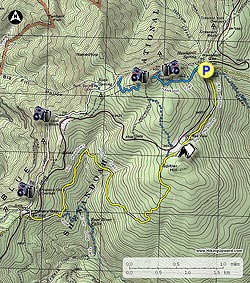
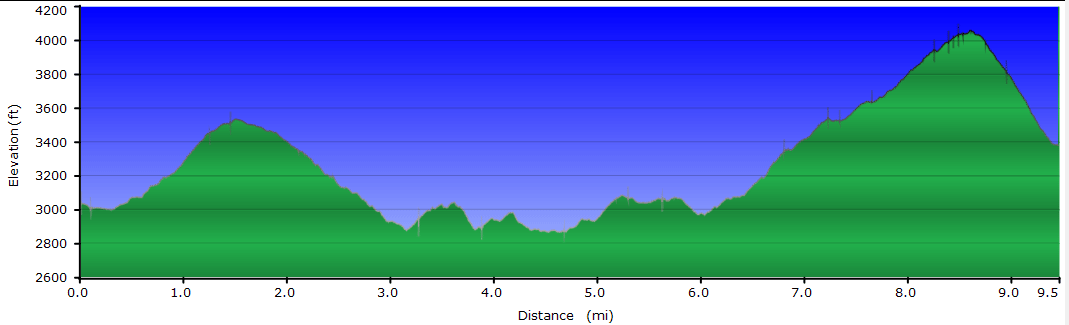
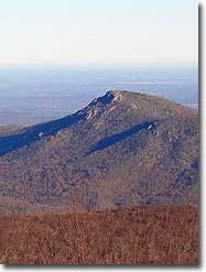
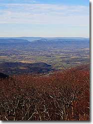
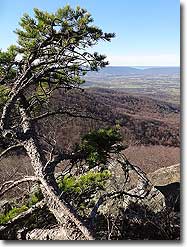
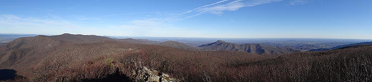
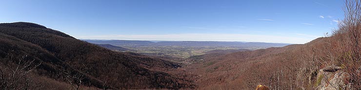
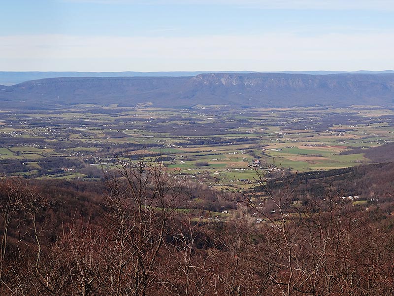
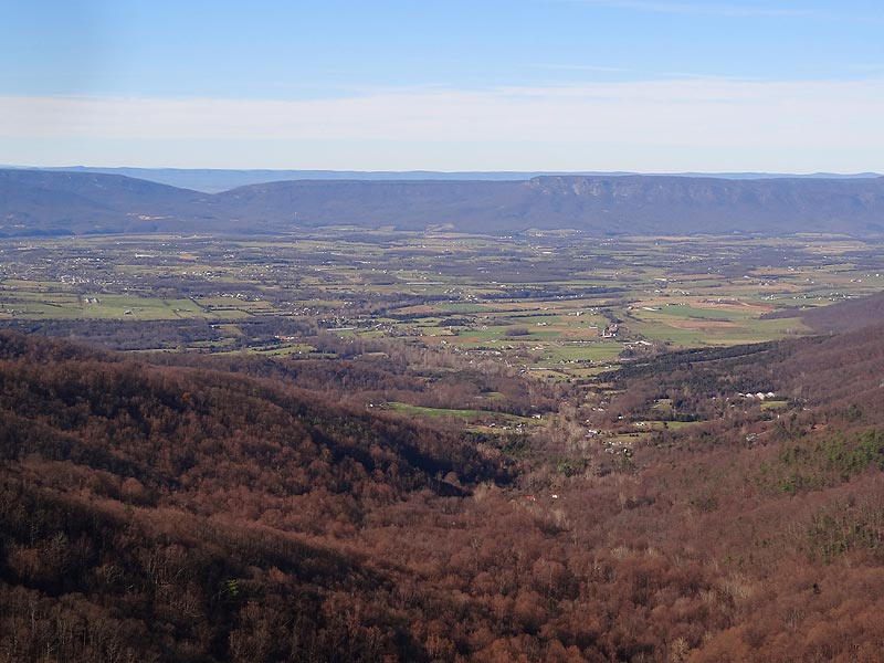
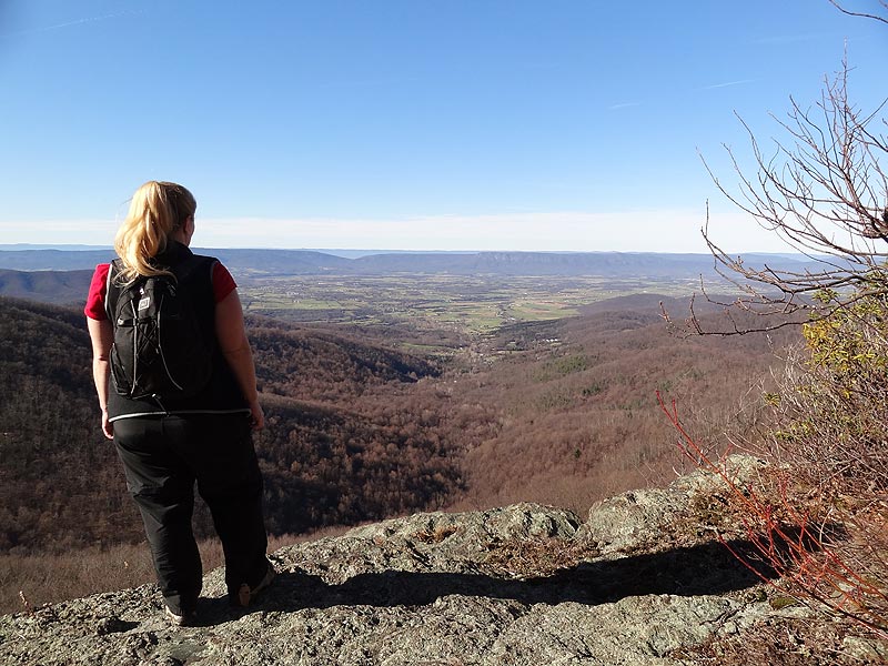
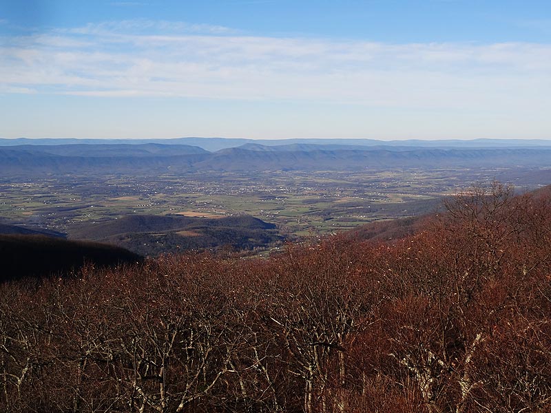
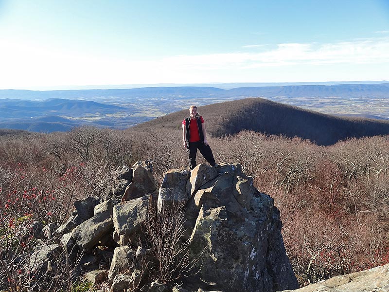
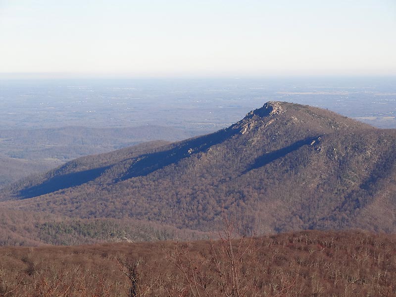
The first half of this circuit is a forest walk that passes 2 feeder streams for Rose River, and the second is vista after vista from both the Appalachian Trail and Hawksbill Summit. The views from Franklin Cliffs look out on the Massanutten range to the west, and there is a spectacular 270 degree panorama from the Hawksbill Summit with a view of Old Rag.
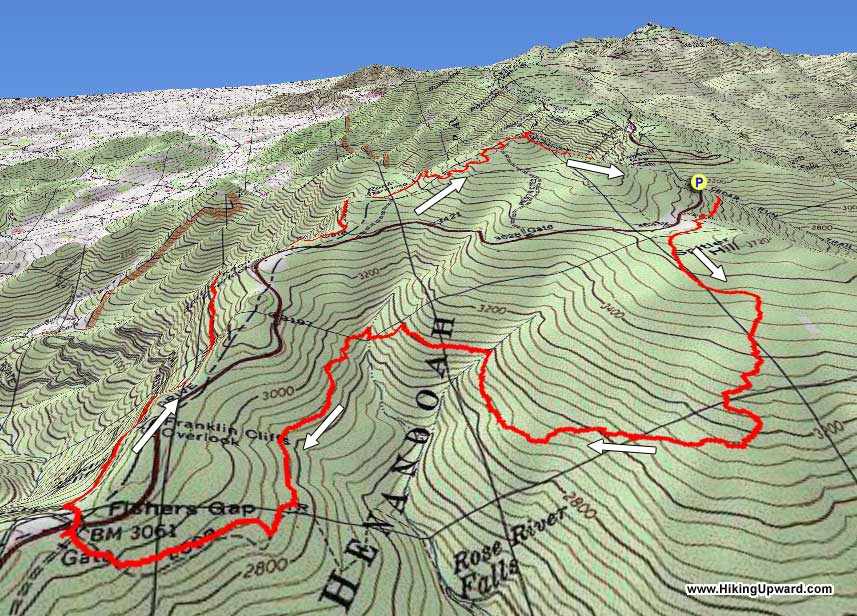
From the parking area start down the Cedar Run Trail for 50 yards to the intersection of the Big Meadows Horse Trail. Turn right on the yellow blazed Big Meadows Horse Trail and in 1.0 miles pass under the Old Rag overlook on Skyline Drive, then in 0.1 miles there is a campsite on the left. 0.2 miles after the campsite the trail will meet the intersection of a blue blazed connector trail that leads to parking on Skyline Drive.
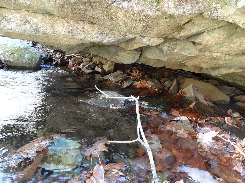
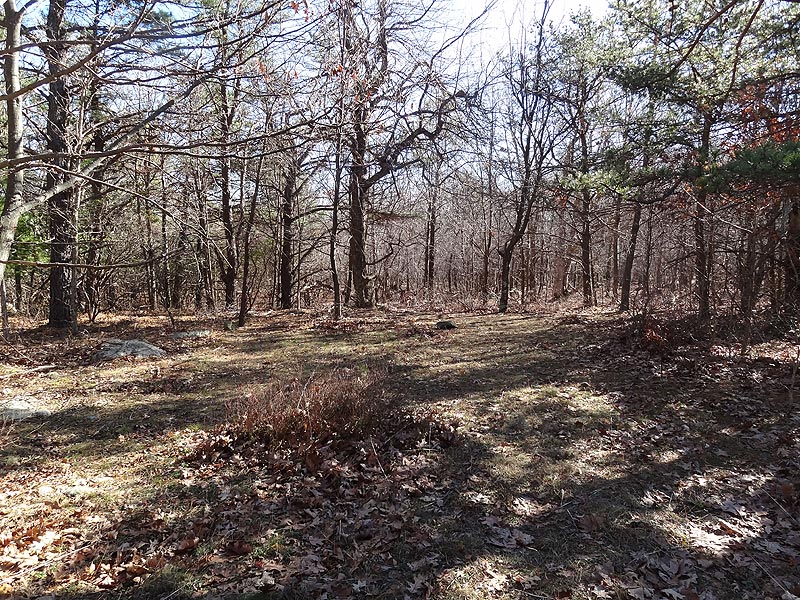
Stay left on the yellow blazed Big Meadows Trail as it now heads downhill before turning back to the right and crossing the first of two streams in 1.7 miles. In another 0.4 miles cross the second and final stream. The Big Meadows Trail now continues for 0.7 miles to the intersection of the blue blazed Rose River Loop Trail. Turn right uphill remaining on the yellow blazed Big Meadows Trail for 0.5 miles to the intersection of a fire road.
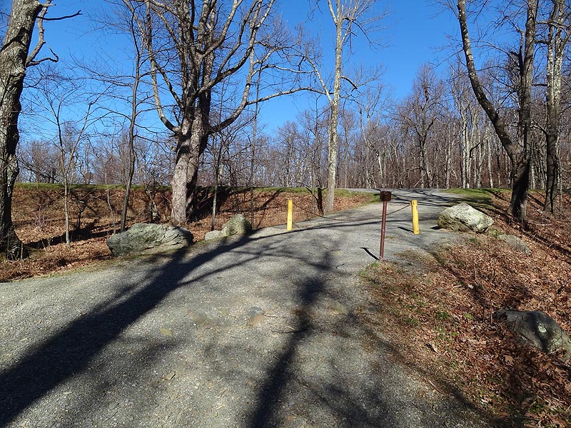
Turn right on the fire road passing a chain gate and crossing Skyline Drive. Continue down the fire road for 100 yards to the intersection of the white blazed Appalachian Trail (A.T.).
Turn right on the A.T. and in 0.1 miles reach the first of several spectacular westerly vistas. Pass underneath Franklin Cliffs, then in 1.4 miles there is a side trail to a Skyline Drive parking area. From this point it's 1.0 miles to the Hawksbill Summit blue blazed trail.
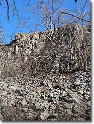
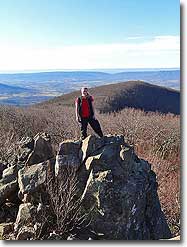
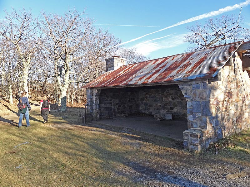
Turn right on the blue blazed Hawksbill Mountain Summit Trail for 0.6 miles to a westerly vista. Shortly thereafter the trail turns left on a fire road on its way to the summit. Pass the shelter then in 50 yards reach Hawksbill Summit where there is 270 degree vista.
From the summit go back past the shelter for 25 yards, and turn left downhill on the continuation of the Hawksbill Summit Trail for the remaining 0.8 miles back to the Hawksbill Gap parking area.
Late November
Hawksbill Franklin Cliffs Hike Comments
Archived Comments
By:John
Rating:
Date of Hike: Tuesday, October 15, 2019
I checked out the hike for the foliage in mid October in 2019. It was still in the very early stages with some a little red here and there, but mostly green with a hit of yellow coming in. I enjoyed the Franklin Cliff section of the AT, though Hawksbill Mountain might had the better view. It was very busy on a weekday afternoon at Hawksbill summit. The Big Meadows Horse Trail was just a connector and a boring one at that in the green tunnels of VA. If solitude is what you are looking for, then you'll have it. The creeks were also dry since it has a been a dry month proceeding my hike. See my detailed report at: https://travel2walk.com/2019/10/16/virginia-hikes-franklin-cliffs-hawksbill-mountain-loop-october-15-2019/
By:Nathan Cross
Rating:
Date of Hike: Friday, November 23, 2018
My wife and I did The Hawksbill Franklin Cliffs Hike yesterday. A very enjoyable hike! The route is great, and the vista from Hawksbill is astonishing. We did have an issue with ice on the trail, particularly on the last mile as you descend from the Hawksbill summit down to the parking area. The grade is slightly steep at times, and the trail was covered in super slippery ice. It was a bit tedious and made for very slow going, but overall it was an excellent hike and highly recommended. Thanks hiking upward!
By:Jamey
Rating:
Date of Hike: Monday, March 26, 2018
This was a fantastic hike in several inches of snow, and it would be even better when the woods are green. I started at the Upper Hawksbill parking area. The woods along Big Meadow are pretty and the beginning stretch on the AT, with the views, cliffs, and mountain laurel, is beautiful. There was one set of boot prints for the first mile or so on Big Meadow, I broke trail to the junction with Rose River, and there were two sets of boot prints on the AT. This was a good workout with all the ups and downs. The snow made it a lot tougher than it normally would be, so I was glad I cut off a mile or so from this site's route. This was a great hike! Ignore the negative comments in some reviews (no, they're not the greatest vistas in SNP, but they're still amazing if you don't like rocks, take a stroll in a city park if you don't want to hear a few cars, don't choose a hike that's near Skyline Drive). The only people I saw were a guy who walked down from Skyline Drive to see the Rock Spring hut (which he somehow missed, despite the cement post and obvious path) and about 10 parking lot tourists at the summit.
By:Rohin Sharma
Rating:
Date of Hike: Saturday, October 28, 2017
Pros: Excellent views, not as crowded or rugged as Old Rag.
Cons: Much more difficult than the 3 that was advertised, $25 fee for Shenendoah Valley
FYI, we did the shortened version, starting at the Upper Hawksbill parking lot--which cutoff about a mile from the trail (our total was about 7.5 miles). Weather was a nice 60 degrees, although its pretty windy when you get to the top. Getting to the Hawksbill Summit is strenuous, but terribly not difficult. The trail from Hawskbill to the other Franklin Cliffs overlook was rocky, but mainly downhill (In case you need it, you will have decent cell phone coverage for this part of the trail).
The most challenging part of the trail was the last Big Meadows Horse Trail. Trail starts off easy, but gets progressively steeper and rockier as it goes. The name is somewhat deceptive, as the trail is really not smooth enough for horses. Be advised, the last two kilometers of the trail is uphill, making the end of the hike the most challenging.
Good hike overall, but the difficulty should be at least a 4.
By:Mike
Rating:
Date of Hike: Sunday, September 17, 2017
Pros: Great hike with beautiful views. The trail is well marked with interesting things to see between overlooks.
Cons: The summit is very crowded. On the day I hiked there was a religious service being held at the summit. Having 40+ people packed into a small area and basically commandeering a public park attraction for their own use was kind of infuriating. Getting the stink-eye for having the audacity to approach the summit area while their service was taking place didn't help my frustration level any.
However, their singing wasn't terrible if a bit pitchy.
By:Great Hike on a Great Day!
Rating:
Date of Hike: Sunday, August 6, 2017
Anytime you get a 70 degree sunny day in August, it is a blessing. And I counted my blessing.
I hiked this clockwise, but started from Fishers Gap parking area at the southern end (MP 49.5). I'm really glad I started there as it put us at Hawksbill in time for a nice lunch mid way through hike. Franklin Cliffs are great, take your time and enjoy it. Hike up Hawksbill Mtn was relatively easy. Hike back on Meadows Horse Trail was a nice walk in the forest, saw a bear, some beautiful wildflowers, and nobody else, which was amazing on a beautiful Sunday in August. Saw no signs that anyone has ridden a horse out here in months. Frankly, there are some steeper, rocky parts I'd be afraid to take a horse. Trail was a bit overgrown in places, but I'm not complaining. Still a nice walk in the woods. My GPS said the distance was 8.2 miles (not 9.2 miles) and we hiked it in 3 1/2 hours plus a little more than a half hour on Hawkskbill, just over 4 hours all together. Enjoy it!
By:Great Day for a Great Hike!
Rating:
Date of Hike: Sunday, August 6, 2017
Just a clarification on my review below. My distance was 8.2 miles rather than 9.2 miles because I hiked down to the UPPER Hawksbill Parking Area while the description refers to the Lower Hawksbill Parking Area. From their map, what doesn't show is a trail from the top of Hawksbill to the parking area further south. You'll see a blue dotted trail that goes to this parking area and then cuts across Skyline to the horse trail. Unless you just want a longer walk in the woods on the horse trail, I'll recommend this way which is one mile shorter.
By:Olivia
Rating:
Date of Hike: Monday, May 15, 2017
This hike was great! I went on a nice day in May.
Although the first part of the hike was just a, "walk in the woods," there were a lot of wildflowers, and when I did it I had two bear encounters.
The outlooks are absolutely gorgeous. The last mile or so down from the summit is pretty steep and rocky. I was glad to take this route because the elevation climb is a bit more gradual.
Otherwise, pretty smooth hike overall. Encountered nobody until the cross of the Rose River on the Big Meadow Trail, and then had a few encounters after crossing Skyline Drive on the Appalachian Trail. Lots of people at the summit.
By:BrianJB
Rating:
Date of Hike: Thursday, December 22, 2016
Nice loop hike on the slightly longer end (FWIW, my GPS read 8.3 vice the listed distance). Nothing too steep or rocky, gain comes over a pretty good distance. If you're willing to bushwack a bit, you can also cut the corner on the Horse Trail down to Rose River falls (did so on a previous loop), and cut some distance at the cost of some additional gain.
Good day for this on balance - didn't see anyone else until I hit the Hawksbill Trail. As noted below, some deadfall but nothing too bad. . .also several sections with deeper leaves, so a need to step carefully for rocks.
By:Mike H
Rating:
Date of Hike: Saturday, December 3, 2016
The description for this hike says that the first half of the circuit is a forest walk, and that is perfectly accurate. The first half is very unremarkable and in truth rather boring. There are no vistas or stream crossings, just a walk in the woods with some uphills and downhills mixed in. But the first half of the circuit exists to deposit you near the Fishers Gap / Franklin Cliff area. The second half of the circuit along Franklin Cliffs is mostly ridge hiking with spectacular views to the west and north the entire way, eventually reaching the Byrd's Nest shelter and observation deck. From the Hawksbill Gap parking lot, one could simply hike uphill one fairly strenuous mile to reach the Byrd's Nest and reach the same climax as the full circuit however, doing the hike this way would cut out the views along the Franklin Cliffs part of the trail. The observation deck gets a lot of foot traffic, mostly from folks who do the much shorter hike.


