The
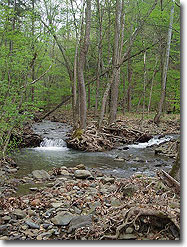
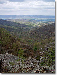
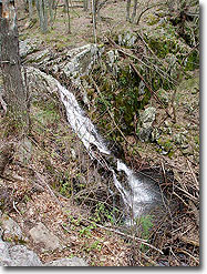
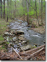
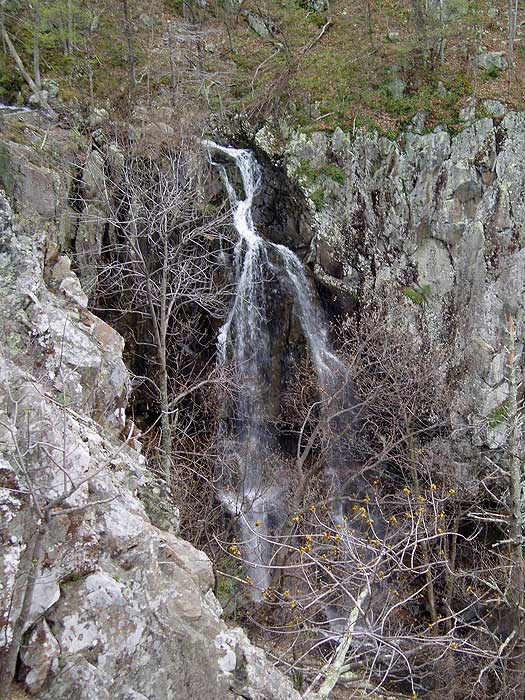
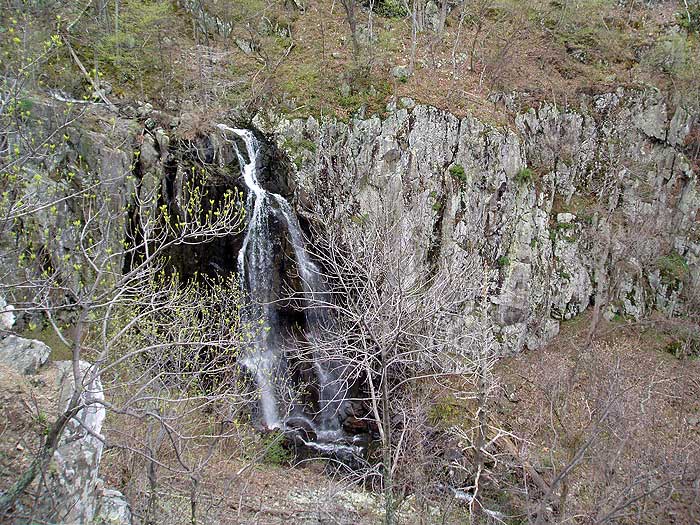
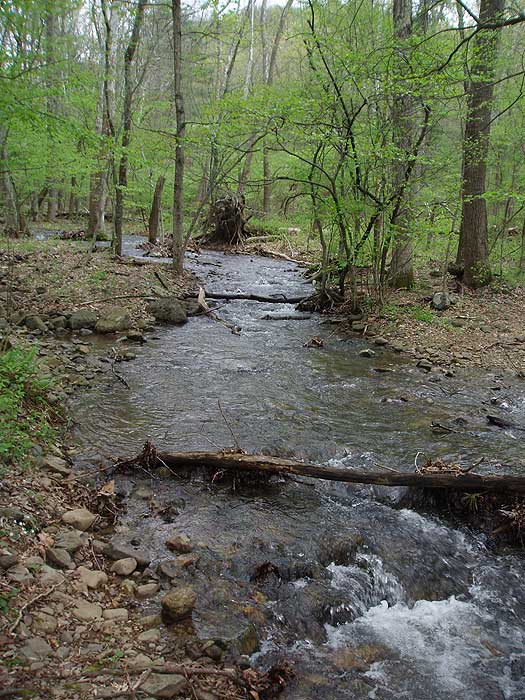
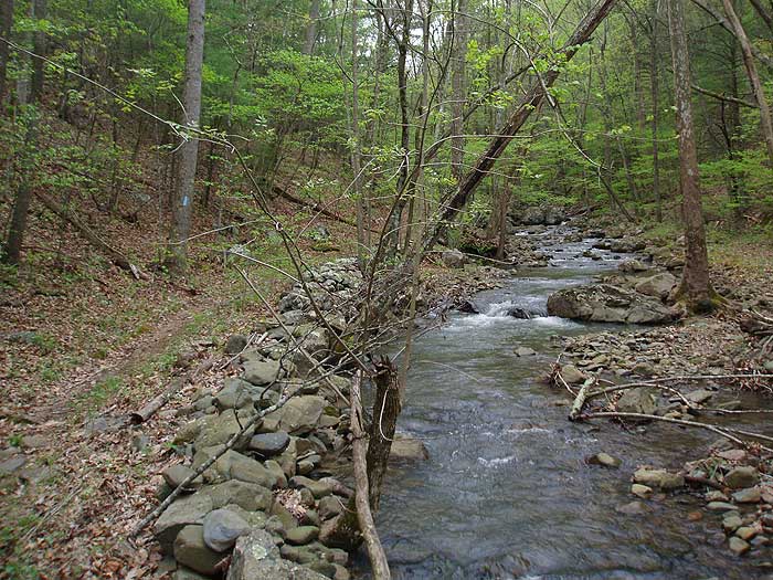
Overall Run circuit passes one of the largest continuous waterfalls in Virginia. The trails also go through picturesque valley streams and meadows making this one of the prettiest hikes in the norther SNP. Also, with Beecher Ridge having one of the highest concentrations of Black Bears in the park, this is one hike where you are most likely to catch a glimpse of a black bear in the wild. If you wish to add some more length, and also catch another small pool with waterfall try the sister hike that enters the park from Chrisman Road VA697, Overall Run/Heiskell Hollow.
Flora - by Julie Ables Chapin
Along this hike in March - June are many opportunities to see native Rue-anemone (Thalictrum thalictroides), a delicate woodland perennial rising to 9 inches. At the top of the stalk is a lacy whorl of 3-parted, dark-green leaves above which rises delicate, reddish-brown stems bearing pink or white blossoms. This slender spring flower is easily cultivated in wildflower gardens and does well in part shade. Unfortunately, equally prevalent is the invasive non-native garlic mustard (Alliaria petiolata) plant, a known toxic decoy to the West Virginia white (Pieris virginiensis) butterfly, a delicate and rare spring-flying butterfly native to the region. Garlic mustardspreads rapidly in wooded areas, smothering native wildflowers, and native tree and shrub seedlings. It can overrun a forest floor in a few years, destroying a previously healthy ecosystem by eliminating many plant species.
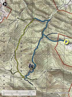
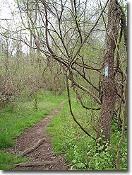
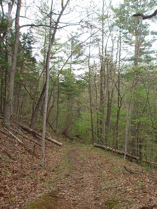
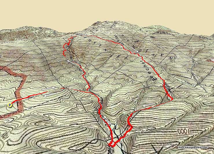
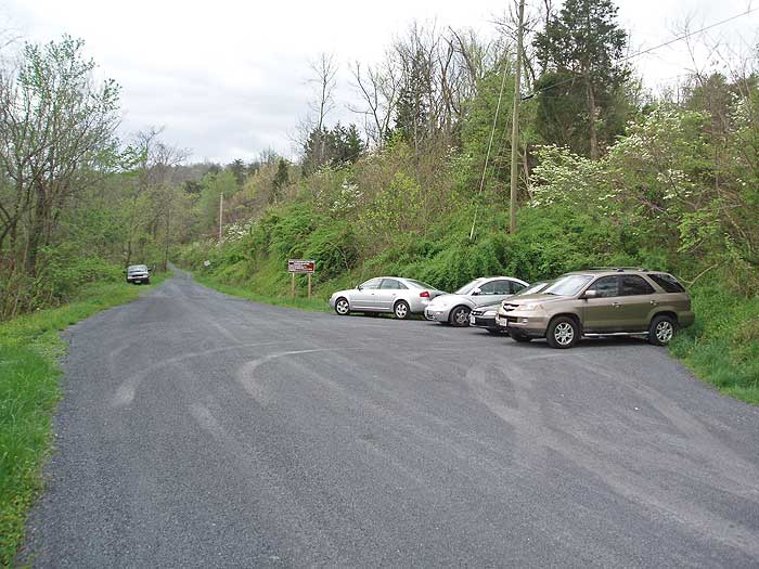
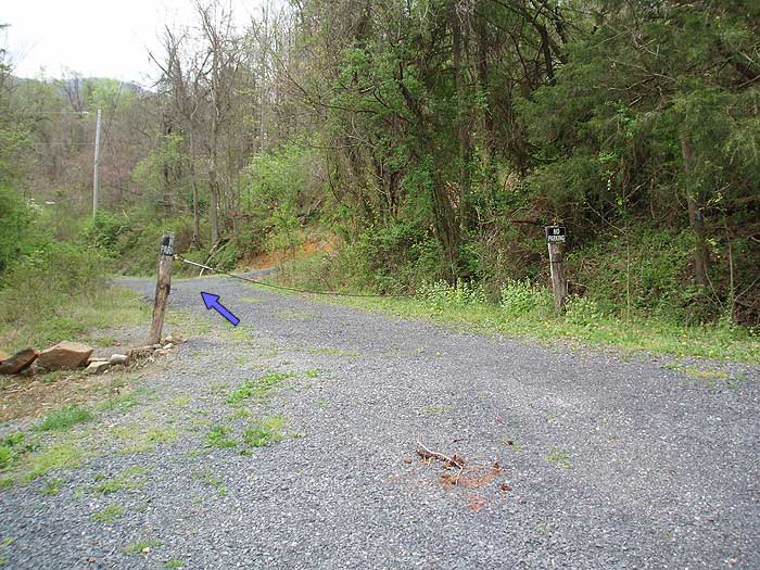
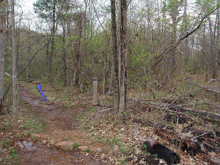
Mile 0.0 - From the parking area, walk down the private gravel road following the blue blazes for 0.2 miles where you pass a cable gate. After passing the cable gate continue for 200 yards where the private road you are on crosses a small creek. Turn right onto the blue blazed Thompson Hollow Trail. DO NOT continue upwards towards the house, this is all private property, please stay on the trail.
Mile 0.3 - Head uphill on the blue blazed trail and shortly pass a marker designating the Shenandoah National Park boundary. In 0.5 miles from the park boundary, and just past the trail high point, reach the intersection of the blue blazed Tuscarora Trail. Continue straight on the blue blazed trail for an additional 0.2 miles to the intersection of the blue blazed Overall Run/Tuscarora Trail.
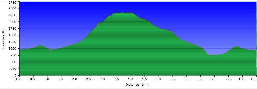
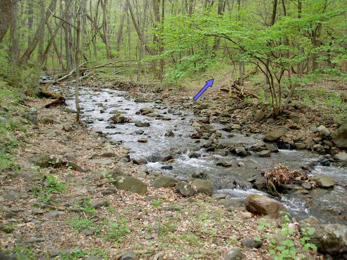
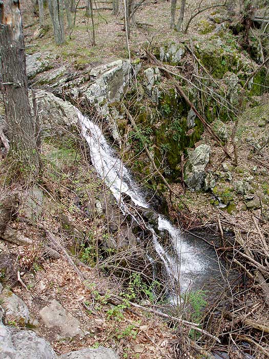
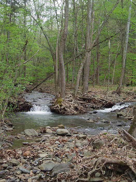
Mile 1.0 - Turn left uphill and cross Overall Run in 0.7 miles. Cross Overall Run again in another 0.2 miles, then the trail starts getting steeper as it climbs towards Mathews Arm. The trail will become very steep with several switchbacks, then passes a small campsite 0.8 miles from the last crossing over Overall Run. From the campsite continue uphill for another 0.3 miles and arrive at the main Overall Run waterfall overlook with spectacular view of the Massanutten Range to the west. From the overlook continue uphill for 0.3 miles passing a smaller set of falls before arriving at the next trail marker. The trail to the left is the no longer maintained portion of the Mathews Arm Trail. Continue uphill on the blue blazed trail for 150 yards to the trail marker and intersection of the yellow blazed Mathews Arm Trail.
Mile 3.4 - Turn right on the yellow blazed Mathews Arm Trail (the yellow blazes may not be visible from the intersection), and shortly cross the top section of Overall Run. In 0.5 miles arrive a the junction of the Beecher Ridge Trail.
Mile 3.9 - Turn right downhill on the yellow blazed Beecher Ridge Trail as is winds its way for 2.3 miles to the intersection of the blue blazed Beecher Ridge/Overall Run connector Trail.
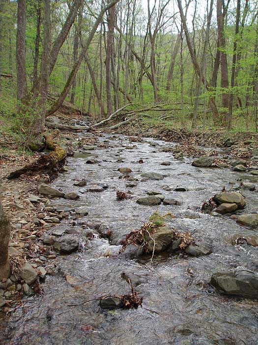
Mile 6.2 - Continue straight on the now blue blazed trail as it heads down to the valley and Overall Run in 0.6 miles. After crossing Overall Run the trail will continue downstream for 100 yards before turning right upstream, and becoming the Overall Run Trail. Turn right upstream on the Overall Run Trail is it follows the run on the left bank before passing a side trail in 0.5 miles. The side trail leads to Overall Run and large swimming hole, with a slide before and after it. Stay left uphill on the blue blazed trail, and in 0.1 miles arrive back at the intersection of the Tuscarora Trail.
Mile 7.5 - Turn left retracing your steps past the Tuscarora Trail turnoff in 0.2 miles, then continuing straight on the Thompson Hollow Trail to the SNP boundary, then gravel road back to the parking area in 0.8 miles.
Mile 8.5 - Arrive back at the parking area.
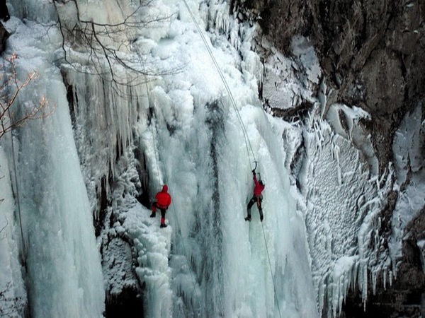
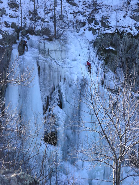
Early January (courtesy of Jayne)
Late April
Overall Run/Beecher Ridge Hike Comments
Archived Comments
By:Scoutdadx3
Rating:
Date of Hike: Saturday, May 25, 2019
Great hike today! We set out from the parking lot around 0830. There were a few cars already there, but it was really packed when we arrived back. We had a small group and hiked the loop clockwise. The initial ascent is steep, but there are places to stop to take in the view and rest for a minute or two. There were lots of people out on the trail today. Most seemed to hike in from the Matthew's Arm area. We also saw a couple of scout troops backpacking for the weekend. Several in our group pulled off ticks along the way. No wildlife sightings today, including snakes. Highly recommend this hike for a great workout!
By:Laura Newman
Rating:
Date of Hike: Tuesday, December 18, 2018
I highly recommend doing the hike counter clockwise. It allows for a more gradual ascend. We have had so much rain lately the water volume was impressive. Some the stream crossings were difficult as many of the rocks were underwater. I would recommend water proof boots with ankle support. Overall great hike.
By:Mary Ann P
Rating:
Date of Hike: Saturday, December 8, 2018
This a beautiful hike and close to Shenandoah River State Park. We did the loop counterclockwise and enjoyed having the great views at the end of the hike. It was a bit muddy at the beginnng but only on the Jackson Hollow Trail part.
By:David S
Rating:
Date of Hike: Sunday, July 8, 2018
I took advantage of this unusually nice summer day to do this hike and I really enjoyed it. The advantage of doing the loop in a counter-clockwise direction is that you do the steep part near the falls downhill rather than uphill. The Beecher Ridge portion of the trail is generally well maintained and not rocky, but a bit brushy in parts so long pants are good if you are concerned about ticks or poison ivy. The only crowded area on a weekend day is the portion of the trail that leads from Mathews Arm campground to the falls. The stream now is low due to dry weather, but there is some water in the falls, and a bit more down below toward the swimming holes.
By:Evan PNW hiker
Rating:
Date of Hike: Thursday, April 19, 2018
First, the GPS cord for the parking area is spot on. As a visitor to the area, I appreciate that.
I did the hike as posted and was glad to get the elevation over quickly. I agree with Katherine I was looking for some evidence of spring it was few and far between. The crispy dried leaves littered the forest floor, and there were still no leaves on the trees an odd sight for a PNW hiker. On this Thursday hike, I ran into only one couple, at the top. So not much pressure at this time. The trail is well marked, which was reassuring to me.
By:Katharine
Rating:
Date of Hike: Saturday, April 14, 2018
I'm a millennial and just did this hike today with a friend. I'd done the longer version of this hike (the Overall Run/Heiskell Hollow one) back in February and LOVED it. The directions for that hike end up being the reverse direction for the parts that overlap for this hike. I recalled going down the steep part of the falls and thinking how much it would suck to go up. It did suck, but it wasn't terrible in my opinion. The vistas made it worth it.
That being said, you could flip the direction of this hike and have the majority of your ascent be gradual. As is, the swimming holes are right at the end before the little arm of a trail back out to the car, but you could still enjoy those doing it in reverse - you'd just continue past that starting arm a little bit, and the swimming holes would be about 10 min down and on the left.
It's mid-April, and the trees don't have leaves yet but some things are starting to bloom, which preserved the views but provided a nice spring-like air.
Filling in some gaps on the map and instructions (in the order of the hike as instructed):
1. at Mile 1.0 where it says to turn left uphill, it's actually left and rather downhill, toward Overall Run. It's a bit farther until you start the uphill.
2. There are a small handful of campsites just a short ways after you make this first left to get onto the loop, which would be great for kids (and we did see several young families) because you're relatively close to the car and it's only mild ups/downs to get there. They're also right next to the trickling water, which makes for fun play.
3. There are a couple of great campsites right around the top of the falls, and one of them is STUNNING, kind of right out on an overlook
4. There are a few campsites along the ridge portion of the trail (forgot to bring a pen, so I can't quite recall where)
5. There's another area for a tent or two shortly before you cross Overall Run (and turn right, upstream alongside it) toward the end.
6. The swimming hole area isn't marked on the map, nor can you really see it from the trail. It's a little more than halfway between that last turn right and the little arm branch trail back out to the car. It's clear that something big is nearby, and if you jaunt about 100 feet down that side "trail" you'll see the swimming hole area. There are a couple of campsites here as well
Additional thought:
If you've got some newbies or young kids in your group, or really want to take it chill, you could break this hike into an overnight and end up with lots of opportunities to frolic in the waters or read for a bit in an eno hammock. It could be a great example of how to enjoy the mountains in a less strenuous way.
By:Kellie W.
Rating:
Date of Hike: Monday, March 19, 2018
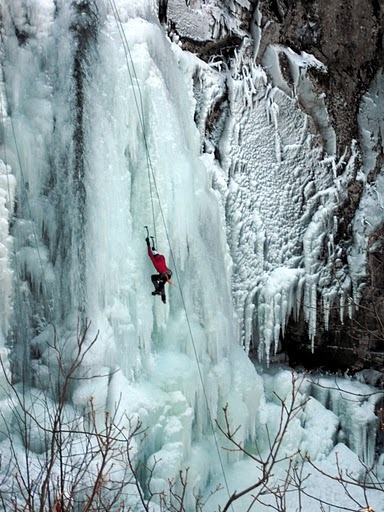
Lovely. Waterfalls mostly frozen this time of year. Gorgeous views. Only saw one other person all day.
Despite the river crossings (not much water this time of year), dont be tempted to wear shoes with no ankle support.
By:Ash
Rating:
Date of Hike: Saturday, December 2, 2017
Thank you to the private land owners that allow us hikers to pass through your lands.
This was an enjoyable day hike. The water was low so no crossings were necessary. Since the foliage is down there were some good views through the trees. I started my hike at 7am and only saw on other person on the trail until the last 1/2 mile when I ran into another group just starting out. The parking area looked like it could hold around seven or so vehicles if people park properly. Only one car was in the lot at 7am and only four when I left (including me) around 11am.
I will probably try the sister hike mentioned in the description during the Spring or early Summer to see how the different seasons are.
By:Mike Nuckols
Rating:
Date of Hike: Saturday, July 15, 2017
My son and I just did this as an overnight backpack. It was AMAZING. Here is what we recommend:
Do it counter clockwise
Day 1: Long day, but take it all the way to Matthews arms trail, go past the overlook (gorgeous) and the campsite is about .25 miles. Total distance for the day will be about 6 miles. Beautiful spot to camp.
Day 2: Finish the loop and end at the water hole that is right near the turn off for Thompson Hollow trail. Bring a bathing suit and spend some time swimming, sliding, and cooling off before you head back to the car. Total distance about 3 miles.
By:Humus Mikus
Rating:
Date of Hike: Sunday, July 9, 2017
I've been on this circuit over many decades. I've never seen the "lot" as crowded as today: over a16 cars! I think most everyone is headed for the swimming hole. It's impressive, even with low water in the streams, but doesn't really support a small community.
I took the Heiskell Hollow trail to extend the mileage just a bit. No water in most stream crossings, and very little water to call a falls, but there was something. Great weather for July, only 80 degrees. That hike up the Overall Run Trail to falls is always a challenge. Good workout! Eat in my knees going uphill, not down. Count me in for the clockwise hike!


