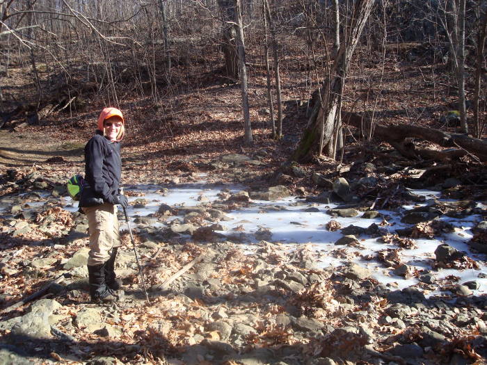
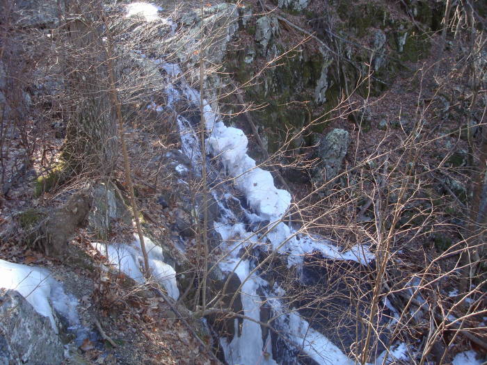
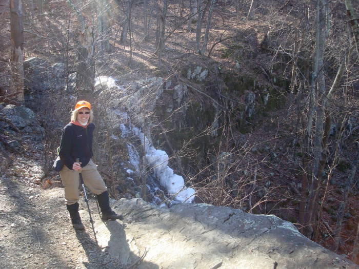
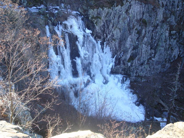
Our first hike of the year in January proved to be a cold one, but due to the cold we saw the Big Falls at Overall Run mostly frozen, beautiful! This is a longer alternate route to its sister hike, Overall Run/Beecher Ridge. This hike has just about everything you would want in a hike: streams, swimming holes, falls, vistas, homestead ruins, etc.
Flora - by Julie Ables Chapin
Along this hike in March - June are many opportunities to see native Rue-anemone (Thalictrum thalictroides), a delicate woodland perennial rising to 9 inches. At the top of the stalk is a lacy whorl of 3-parted, dark-green leaves above which rises delicate, reddish-brown stems bearing pink or white blossoms. This slender spring flower is easily cultivated in wildflower gardens and does well in part shade. Unfortunately, equally prevalent is the invasive non-native garlic mustard (Alliaria petiolata) plant, a known toxic decoy to the West Virginia white (Pieris virginiensis) butterfly, a delicate and rare spring-flying butterfly native to the region. Garlic mustardspreads rapidly in wooded areas, smothering native wildflowers, and native tree and shrub seedlings. It can overrun a forest floor in a few years, destroying a previously healthy ecosystem by eliminating many plant species.
Hiking this trail at any time of the year would be enjoyable. We pictured ourselves taking a dip in some of the huge swimming holes when the weather is warmer. If you have done Overall Run before, come back out and try this route, over half of it is on new trails, you will not be disappointed.
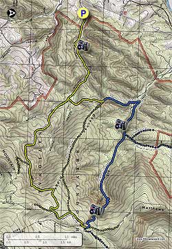
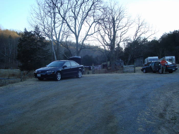
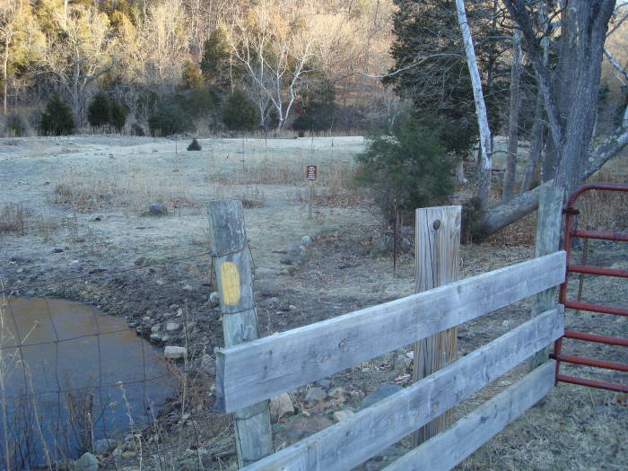
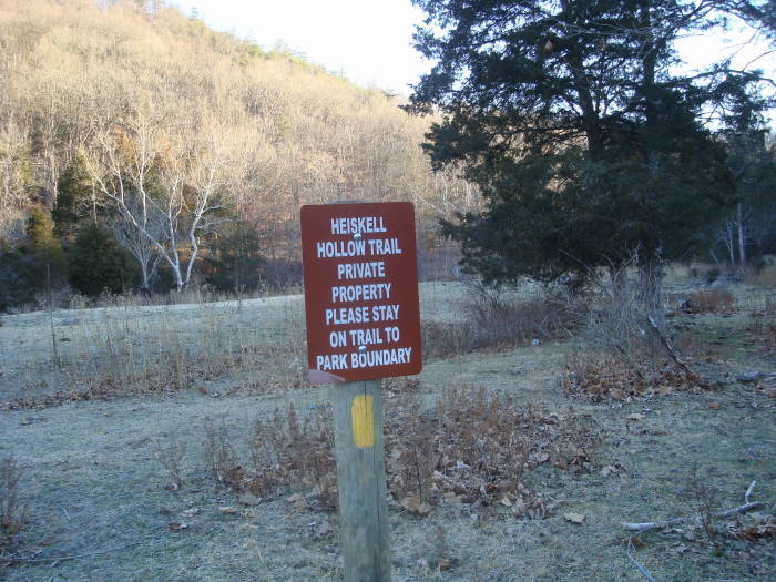
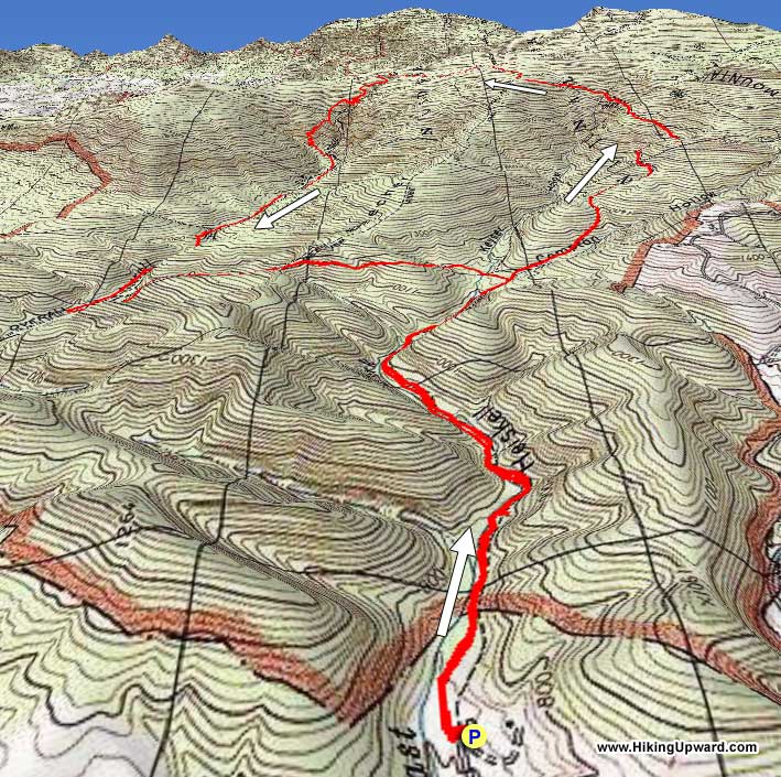
Parking is at the end of graveled Chrisman Road (VA-697) and is really just side of the road parking, if done well you could get 4-6 cars parked here. Do not block either of the farm gates. The trail begins at the first gate, there is a yellow blaze on the fence beside the gate, go through the gate (close it properly)and head to the left towards the brown Heiskell Hollow sign, the trail bears to the right of the sign.
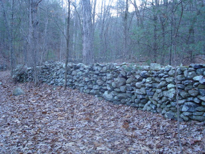
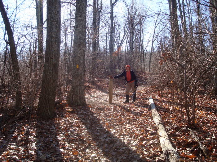
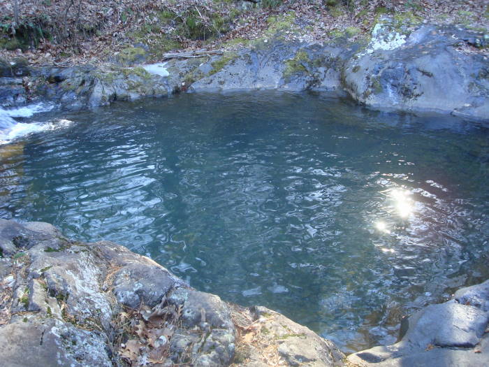
You are on private property for 0.3 miles until you reach the Shenandoah NP Boundary gate, so please be respectful and stay on the trail. From the SNP boundary you will be following East Fork Creek, passing remnants of a homestead/fireplace and stone wall on the right, and in 0.4 miles from the SNP Gate you will reach a small falls and swimming hole (Mile Mark 0.7). Continue on the trail crossing the creek about 3 times for 0.8 miles and then bear to the left staying on the trail, DO NOT continue straight (MM 1.5). Note: All other intersections on this hike will have SNP concrete intersection posts. In 0.4 miles beyond this intersection reach the the first intersection with a post and continue straight on the Heiskell Hollow Trail (MM 1.9).
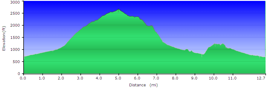
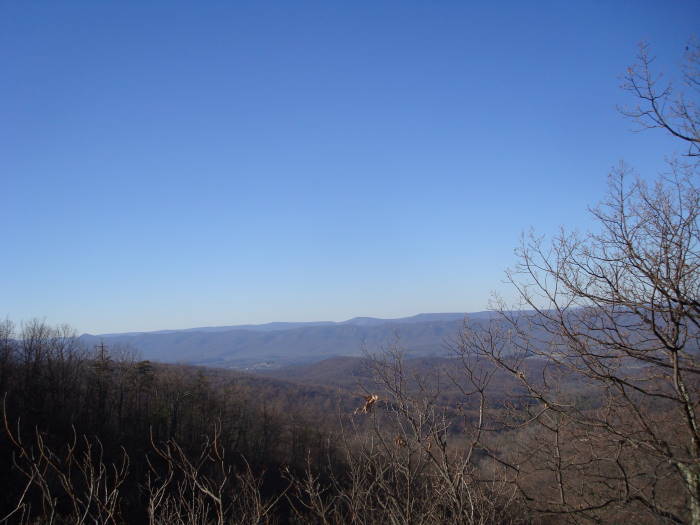
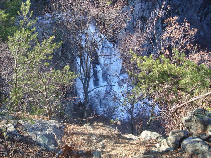
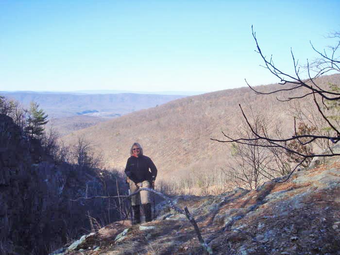
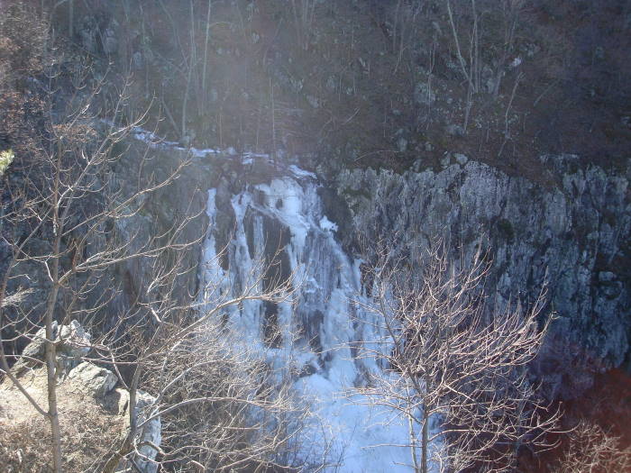
The trail to this point has been very gradual, but the next section you will start to climb, gaining 1100' feet in 1.7 miles reaching the next T-intersection MM 3.6. Go left onto the Weddlewood Trail. Continue climbing reaching the highpoint (2670') of the trail at the next intersection in 1.4 miles (MM 5.0), bear left onto the Mathews Arm Trail. Go 0.5 miles, passing the Beecher Ridge Trail intersection on the left (MM 5.5), bear right staying on the Mathews Arm Trail and in an additional 0.5 miles bear left onto the Overall Run/Tuscarora Trail (MM6.0). This trail will start to descend very steeply reaching some great overlooks of the falls in another 0.5 miles (MM 6.5). There is a side trail that gets you a little closer to the Falls, be careful, great stop for lunch. We did this hike in January and saw the falls frozen. There are some great views of the Page Valley with the Massanutten Range in the background. From June on the Falls can be barely a trickle without some sustained rains, so the ideal time to see the falls is January to May.
Continue to descend and in 0.3 miles off to your left is another small overlook with a possible campsite just below that. The trail continues to descend rapidly and reaches the Thompson Hollow Intersection in 1.6 miles, continue straight (MM 8.6). In about 0.10 miles after the intersection is a side trail on the left to a large swimming hole and slide. The next intersection is 0.7 miles from the swimming hole, bear hard left onto the Beecher Ridge Connector Trail (MM 9.4). The elevation is 800' at this intersection and besides the parking area, this is the low point of the hike. You will have a short but tough 0.7 mile hike up to the Beecher Ridge Trail Intersection (MM 10.1). Bear to the right, heading to the Heiskell Hollow Trail, reaching that in another 0.7 miles (MM 10.8). Turn right onto the Heiskell Hollow Trail reaching Chrisman Road parking in 1.9 miles (MM 12.6).
Early January
Overall Run/Heiskell Hollow Hike Comments
Archived Comments
By:Ash
Rating:
Date of Hike: Wednesday, November 27, 2019
The day before Thanksgiving and not a sole but me on this trail. I wasnt in the mood for miles of rocks today and that really put me in the wrong headspace. The first five miles were fine, and I liked getting most of the vert at once, but once I started coming down the rocks were relentless. Some days the rocks are just something you deal with, other days you wish every rock in the state would disappear - today was the later for me. I dont knock the trail for it though. Its a pleasant trail with great views. Not lots of water to worry about today, although it was raining when I drove to the trailhead.
I did the Overall Run/Beecher Ridge two years ago and there is a lot of overlap between the two. I wouldnt feel like someone is missing out if they did that one and never did this one. You do miss the watering hole, but if thats not your thing then the only other plus is additional mileage.
By:Brian Alexander
Rating:
Date of Hike: Saturday, June 15, 2019
I did this hike on a warm summer Saturday with a few friends from Central Virginia Trailblazers (https://www.cvatrailblazers.org). As we started out through the gate at the beginning, we were greeted by some very vocal cows who helped us find our way to the trail.
I was wondering if the landowner is trying to discourage hikers, as the trail was quite overgrown and there was no "Heiskell Hollow" sign as mentioned in the description. But there is a somewhat faded yellow blaze near the gate. Once we reached the main loop, the trail was wider and more typical of other SNP trails. We proceeded on and had no trouble following the directions, but the mileage seemed to be off by about a half mile starting around the 8.6-mile intersection, which we reached at around 8.1 per the MapMyHike app, with the total being around 11.5. We didn't encounter many hikers until we got close to Overall Run. If you hike this trail in the summer, my advice is wear long pants and use insect repellent!
By:Shafqatullah Syed
Rating:
Date of Hike: Sunday, August 26, 2018
Finding this place on my GPS was not difficult. I almost missed the final turn. There is a no outlet sign at the turn. Its a dirt road and the parking area is a tight round opening that only about 4-6 cars can manage. To my surprise there was another car when I got there but it had frost on it and it did not just get there. I put on some DEET tick repellent as I read other hikers complained but I did not have any issues the whole way.
Started hike at 5:30am. Climbed over landowners gate and continued on to trail system. Approached SNP boundary line/gate. Kept going and not too far ahead I went around a tent and two campers sleeping in it. I printed out the topographical map and mile directions. Since, this was my first hike here I just kept to them and never got lost. I also had a head light which was essential for the first few hours of darkness until the sunlight was enough to see my surroundings. I never encountered any bears as others have documented and I would know what to do if I did get close to one. The only two items I saw where a large dropping which I never have seen so I assumed it was bear and about a quarter mile further there was a huge claw/paw print in the mud. Both of these were fresh so I kept walking. The hike was excellent. It does start off gradually and it is almost a walk in the park but then it quickly ascended to its peak but not at one shot. There was a break about half way in. I then entered the portion of this hike that was meant for the SNP visitors and I saw my first trail runner on the part when it opens up and sharply descents. I prefer going up as it is easier on my injured ankle. For the most part the trail was descending either sharply or gradually the whole distance that was originally gained.
Toward the half way point while descending you are able to stop and sit on rock cliffs for some grub- taking in the beautiful cliff-side waterfall and on the opposite side the valley and rolling mountain view of multiple ranges and colors. I was not aware of this but it was breathtaking and so beautiful. I continued down while the few people I saw just turn around and go back up to the SNP parking area. At the bottom elevations the creek is always on the left side and there are a few areas of smaller rapids and waterfalls that form a pool for taking a dip. I trekked on until I finally got to the connector to the backcountry trail I originally started on. It starts with a yellow blaze and then the parts it overlaps the other trail is blue. I was alone almost all the time and only encountering other hikers in the stretch to and from the falls and the swimming holes.
When I got back to the parking area I could see what was around me as it was all hidden in the darkness of the morning. There were a few old shacks and then a trailer with clothes drying on a few clothes lines. As I drove I could see that there were more broken and old structures until I got out to a real road.
I loved this 13-mile hike. It has a lot of technical diversity from the multiple stream crossings, rock gardens, ups/downs, and flats.
By:B
Rating:
Date of Hike: Saturday, April 14, 2018
The first time I ever saw a black bear in the wild was on this hike! None this time around, but there were lots of people enjoying the swimming holes (so endearing to see little ones and doggos and grown folks playing, laughing, setting up hammocks, loving life). The cold of the water will take your breath away, but in the most delightful way -- especially when you can dry off on the rocks and soak up some Vitamin D on an 80 degree day.
The hike itself ain't so bad for almost 13 miles. With breaks and about an hour of water playtime, it took my brother and I 6 hours to finish (note - he'd never hiked more than 5 miles, so this is totally doable for anyone reasonably in shape). The last climb is a wonderful ass kicking after playing in the pools. Most of the trail was pretty quiet for a Saturday, with the exception of the falls/overlook, and where it intersects with Beecher Ridge (shorter version of this hike). The trees haven't quite filled in, so there wasn't much shade throughout the hike (quite welcome after the many cloudy days we've had). Paler friends, bring sunscreen! Everyone, bring bug spray! And lots of water! And an open heart (always bring that :)
Such a lovely hike - go do it. And THANK YOU to the folks who allow us to park and start on their property <3 Namaste!
By:J Hicks
Rating:
Date of Hike: Thursday, April 27, 2017
Ticks... While I don't believe ticks are worse on this hike due to some weird ecological issue, I will say they were very bad today. Worst I've seen this year. Also, unless you want to take your socks and shoes off 13 times, don't do this hike even a few days after some rainy weather. Eventually I just decided to finish up with wet feet. Just pulled two more ticks off me that are escaping my treated dog. Ugh...
Saw quite a bit of wildlife including turkey, bear coming down from a tree, owl, heron, rattlesnake and amazing small birds. The first 6 miles goes up, up, up. Makes for a great workout.
Word about the start/finish... There were cows in the field you need to traverse to get to the forest boundary. At first I thought about bagging it but decided to just give them space. No problem and then I came across a very large bull. Fortunately he wasn't interested in me but I would recommend caution if he's out.
Enjoyed the hike. The ticks and wet feet not so much...
By:Savage
Rating:
Date of Hike: Thursday, June 9, 2016
Living on the Page side of the mountain this access to these trails is perfect, BUT BEWARE!!! After the initial 2-3 miles through the "backcountry" til you get to the connecting trails. My 6 month old Weimeraner dog was COVERED in ticks. I pulled about 20 off there at first intersection. When we got to the falls I pulled another 10-15. By the time we got home and bathed and went to bed I pulled almost 100 ticks off the dog if not more. About 5 on myself, Ive always stayed well covered as you should if you travel this trail in warmer months as the trail gets narrow and overgrown in spots. Ive been hiking for 15 years and I've never seen anything like that with ticks. Large and also small ticks that you can barely spot. Other words, I wouldn't advise taking a pet if they aren't protected. Although he is, I am contacting my vet for any other precautionary measures. Sadly, I do no think I will access these trails from Heiskell Hollow again unless it is in the winter months when ticks aren't bad, hopefully. Alot of wildlife travel the trail, which I suspect makes them so bad (deer, bear), and it could very well be tick season? Hike itself is a bit challenging if you aren't a regular hiker. I went on a Wednesday, so other traffic on the trail was minimal. Came across 4 others from Skyline Drive access and campgrounds.
By:estdc
Rating:
Date of Hike: Saturday, May 23, 2015
Relatively easy (albeit somewhat long, beware) hike, though the mile markers as listed in the description seemed inaccurate (felt shorter).
Parking was as described, and room is tight. (There were, however, no other cars there when we arrived, a truck with horse trailer arrived as we set out, and no other cars when returned - so despite seeing many people on the trail, this particular access may be a relatively well kept secret.) We did our best to take up the least amount of space possible, making sure cars would have room to turn around. The first part through private property and a cow field notably felt a bit awkward, but the trail was marked. The parking gave the illusion of a very secluded hike, but in that regard we ended up disappointed.
Initially there is a number (4 or 5) of stream crossings (wise to bring a second pair of socks). The long climb in the early part is very gradual, and - with the exception of a few spots - not challenging, particularly relative to other trails I've hiked in the area. From the start to the end of the initial climb was the most pleasant and secluded, walking through quiet and beautiful woods.
However, once at the highpoint, turning left onto the Matthews Arm Trail, the trail itself became very wide and busy, with lots of walkers (I suspect from a nearer parking lot given the many small children) heading to the Falls. At the Falls, too, there were many people. We notably made the mistake of stopping at the first indication of the Falls for lunch, rather than carrying on for the better Page Valley and Fall views half a mile further, where despite the crowds people weren't so tightly packed together.
Past the Falls, the trail descends steeply, eventually with switchbacks, before leveling out and following the stream . In this part the description seems inadequate, given particularly the many little trails to campsites or overlooks that dart off to the side, as well as people near and off the trail. We were concerned that we had lost our way, but the route actually ended up being intuitive.
The final .7 mile climb nearing the end of the hike is quite steep but brief, and toward the final third or quarter we had more privacy again.
Overall, it was a good hike. However, I found it to be not very challenging, too busy, and with disappointing outlooks (which we couldn't really enjoy, anyway, because of the crowds, noting that we were there on a holiday weekend, in perfect hiking weather). I enjoyed it but wouldn't consider it a great hike to do again.
By:Jimmy
Rating:
Date of Hike: Saturday, May 2, 2015
This was a great hike, that like described in previous reviews contains a little bit of everything. Finished this in right at 6 hours, including some time for pictures and lunch at the falls. Saw about 20 people over the course of our time on the trail. We were the only people parked at the Heiskell Hollow trail head though.
No sign of ticks but I'd definitely be conscious of them, especially as it gets warmer. Most of the Heiskell Hollow trail is thick with dead leaves. There is a fair amount of dead fall on the trail as well. The water level wasn't too high during our trip, so crossings were not that difficult. It's definitely something to take into account though before you head out for this trail.
The views of the falls are amazing and i'd love to come back in winter and see them frozen over. I also highly recommend taking the small side trail to the rock slide and swimming hole at mile marker 8.6!
One last thing. The cows at the trail head are friendly and mind their own business.
Cheers!
By:TessaK
Rating:
Date of Hike: Sunday, January 25, 2015
This really is a 'bit of everything' hike but be warned: if the water level is moderately high, there will be a lot more than 'about three' stream crossings. We crossed the stream 15 or 16 times, ten of which required wading through. The other 5 crossings were rock hops. In lower water, most (all?) are probably rock hops, but then the falls are maybe not as impressive. Given that we passed at least two swimming holes though, I still think it would be a fun summer hike.
By:Derak
Rating:
Date of Hike: Saturday, December 13, 2014
Overall, this was a very enjoyable hike. The directions above are helpful. Just a couple of things I'd mention:
(1) If you are doing this to see Overall Run Falls, I'd recommend going in cooler weather. Many streams, especially in the higher elevations of the Appalachian Mountains, dry up during the summer months. We went in December and the falls had plenty of water and were partially frozen. Despite above freezing temperatures during the day, the falls stayed icy thanks to the low near-winter-solstice sun.
(2) We did this hike on a Saturday in mid-December. Although another review disagreed with the solitude rating, I'd agree with the three rating given. We only ran into a couple of other groups and almost all of them were around the falls. I've found that solitude often depends on two main things: timing and luck. Obviously, your chance of seeing others increases on weekends and during certain times of year. The directions above create a loop using multiple trails, some of which come close to Skyline Drive and swimming holes (which usually means youre more likely to run into other hikers). Despite encountering a few other people, we couldn't see or hear other hikers for over 95% of our trip.
(3) If you follow the directions above, you will do the loop counter clockwise. This will bring you to the highest altitude on the loop and then down to the top of the falls. Reversing the directions and doing the loop clockwise will take you to the foot of the falls and then up to the highest altitude along the loop.


