This
is a short and pleasant hike, and has
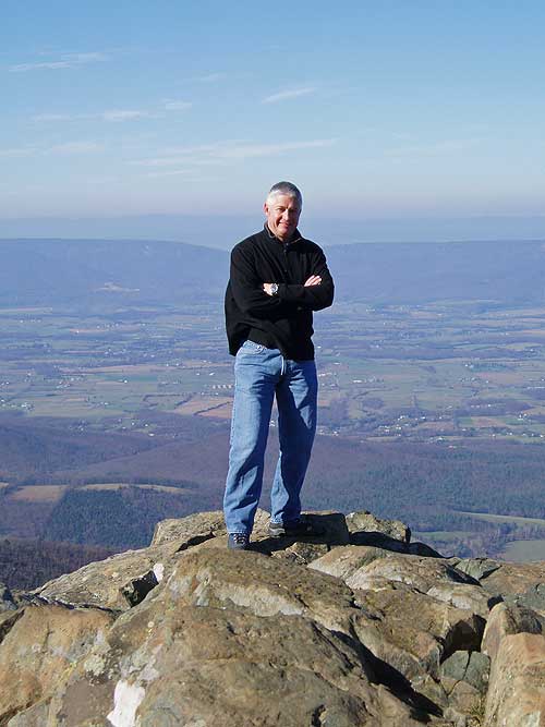
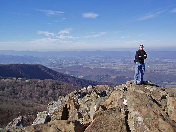
some of the best vistas in the Shenandoah National Park. Little Stony Man, just below the main peak, has a popular rock wall with local climbers. Make
sure to pick a haze free day, because you don't want
to miss all the views along the the ridge!
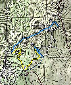
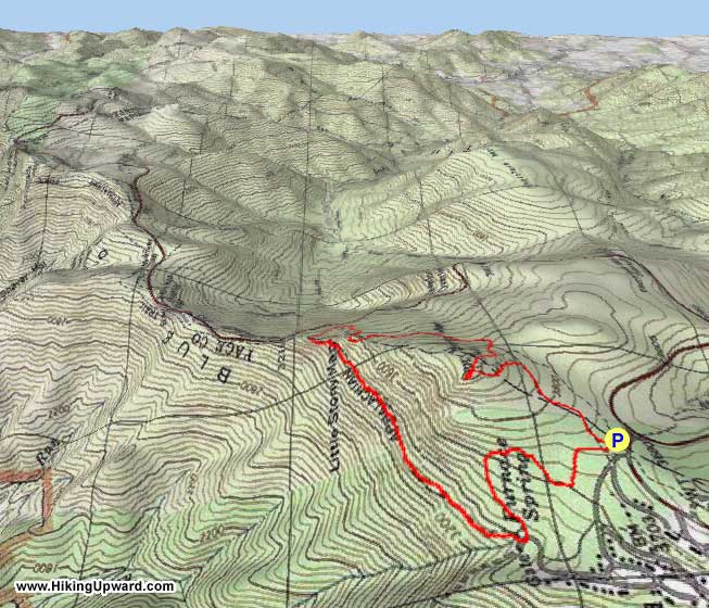
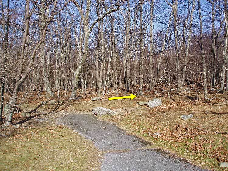
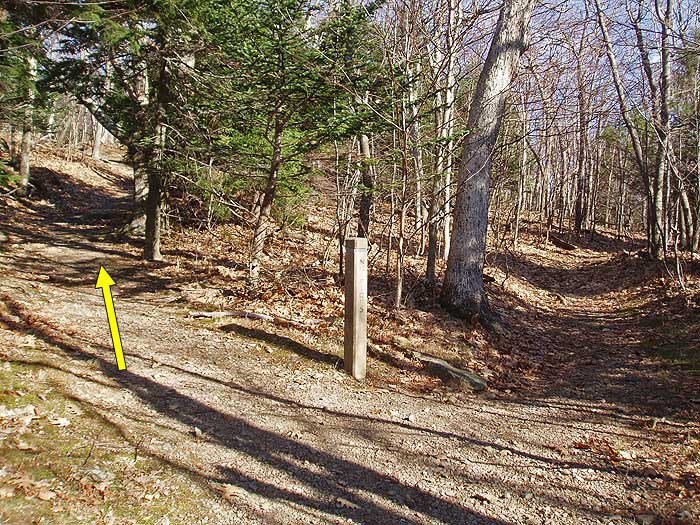
Start the hike on the left of the parking area at the trail junction. Turn right on the on the yellow blazed Stony Man Trail for 0.5 miles to the intersection of the Horse Trail.
Turn left uphill on the Horse Trail for 0.5 miles and come to the first of the
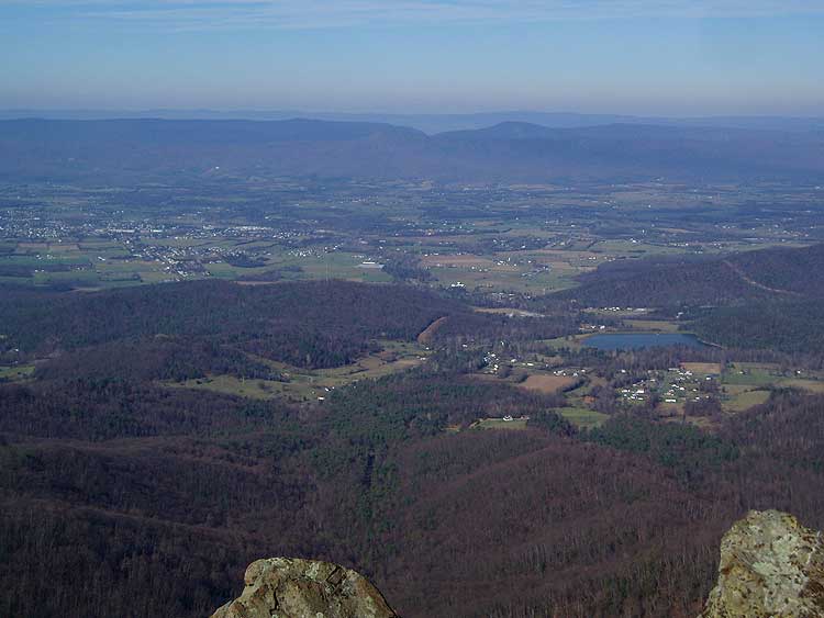
Shenandoah Valley overlooks. Continue up the trail for another 50
yards to the junction of the the
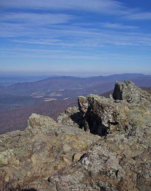
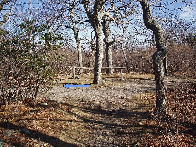
blue blazed trail, and horse rail. Turn left, and in 80 yards arrive at the main Stony Man Mountain overlook.
Return back, passing the trail you turned off in 80 yards, where the blue blazed trail splits. Stay left, and in 0.4 miles the trails rejoin. Continue downhill for another 0.1 miles to the the four way intersection of the white blazed Appalachian Trail.
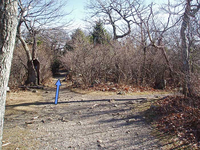
Turn left on the white blazed trail for
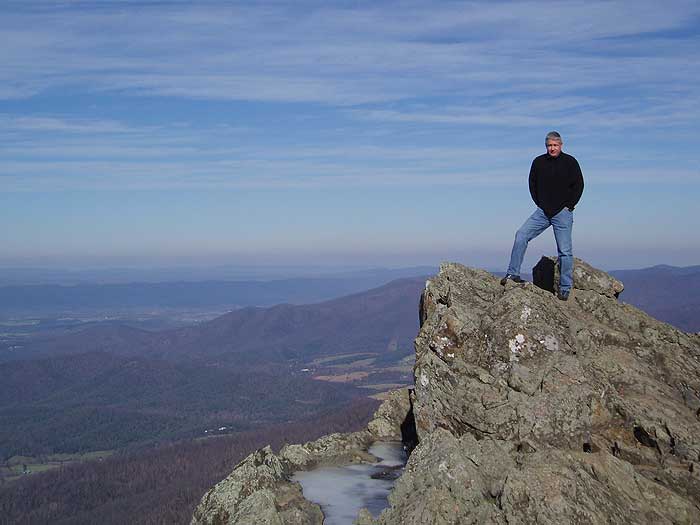
0.7 miles to the Little Stony Man overlook. As you continue
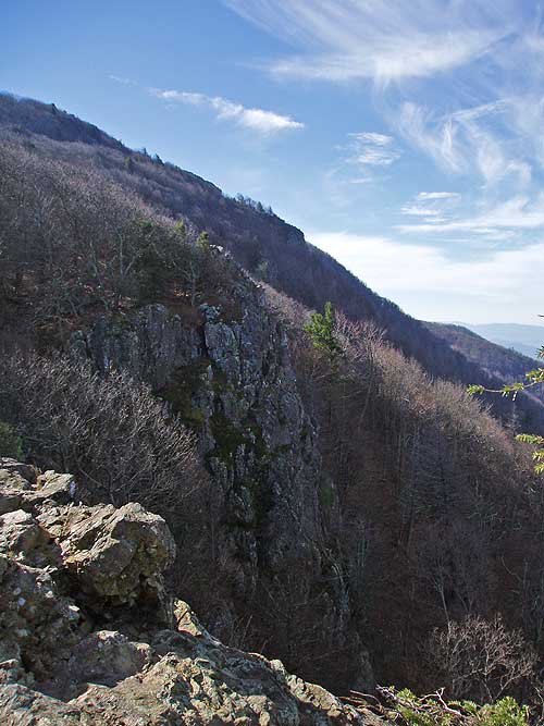
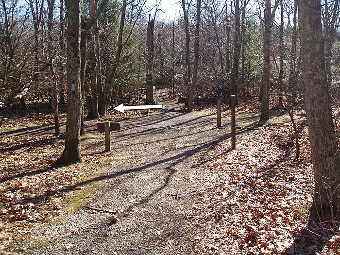
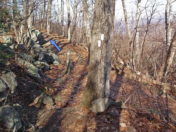
downward make several switchbacks before reaching the left turn for the blue blazed Passamaquoddy Trail. The Passamaquoddy Trail turnoff is easy to miss. Look for a concrete post marker and a double white blazed tree marking the junction.
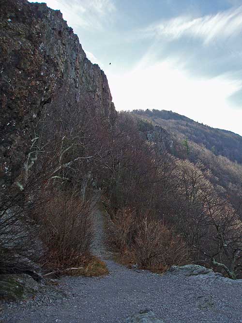
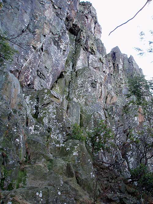
The Passamaquoddy Trail will pass a lower vista at the base of the Little Stony Man Mountain cliff face. Continue around the mountain for 1.0 miles to the junction
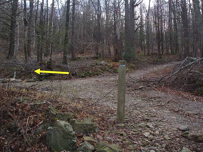
of Furnace Spring Road. Turn left uphill for 20 yards, then make a sharp turn to the left again onto the yellow blazed trail. Follow the yellow blazed trail as it winds uphill, arriving back at the Stony Man Mountain parking area in 0.5 miles.
Early December
Stony Man Mountain Hike Comments
Archived Comments
By:Brian Schwarz
Rating:
Date of Hike: Thursday, October 24, 2019
The hike described here is perfect. I was worried that hiking at the height of the October I'd be overwhelmed by novice hikers along the entire trail route. And, well, the summit of Stony Man was overrun. However, for 90 percent of the hike I was all by myself and had a wonderful, peaceful hike. The Passamaquoddy Trail section is my favorite. There is an amazing view here, too. In fact, there are three stunning rock outcrops along this hike! It felt so isolated at times, and it reminded me of hikes I've taken out west, particularly in the Sandia Mountains outside of Albuquerque. Follow me on IG at "brianopolis" to see some pics!
By:Diego
Rating:
Date of Hike: Friday, September 6, 2019
Was going to do this hike today, but ended up not because I had a dog with me, and this trail doesn't allow dogs. Hadn't seen anyone mention that before, so figured I'd let people know to NOT bring your dog on this trail.
By:TAG
Rating:
Date of Hike: Monday, December 24, 2018
We were blown away by how beautiful this hike was. It was bitter cold and windy on December 24th but the trail was coated in snow and the leaves were gone which made for a magical snowy scene. The early vista was beautiful. There are two paths out to separate peaks here which are close enough that we photographed each other from opposite peaks. Amazing photos. The short ridge area was a beautiful lookout in itself and we even saw ropes attached there where people were climbing up the cliff side. Further down passamaquaddy trail was yet another beautiful vista. We loved every minute of this hike and look forward to coming back in different seasons to enjoy different views.
By:Jennifer C.
Rating:
Date of Hike: Monday, April 17, 2017
My husband and I did this hike after checking in at Skyland lodge, (Our room had an amazing view and was very quiet and peaceful.) We had planed on doing the hike the next day, but since all we had to do was walk out our door to begin the hike we decided to do it that evening. We our both in good shape so we were back before sunset. We began by taking the Passamaquody Trail from our room to the Little Stony man summit which was really nice and peaceful. We then turned right on the Stony Man Trail and then decided to go left where the trail splits and went to the Stony Man Summit. We then took the stony Man Horse Trail back to the road that goes to Skyland in order to make it back for our dinner plans. My favorite part of this hike was walking along the edge of the mountain on the Passamaquody Trail and how quiet it was. Really nice views of Luray.
By:Heather H.
Rating:
Date of Hike: Sunday, September 4, 2016
It was a beautiful day and not too hot so we decided to take advantage of the nice weather with a hike. I read about this hike in a magazine and decided to check it out. The trail markers are definitely confusing and we somehow found ourselves at the Skyland Resort where the cabins are. A nice couple shared their map with us and we walked along the road back to the parking area. The trails to the overlooks are pretty crowded but the Appalachian and Passamaquoddy Trails were less crowded. The overlooks were great, it was a clear day so we could see pretty far. This was a very easy trail, not many inclines or challenging parts. I liked the hike but I don't think it's worth the $20 fee to get onto Skyline Drive. Unless you plan to do some other hikes or take advantage of the overlooks. We drove 3 hours round trip and the hike took us about 2 hours. Granted we did get off course but I think we probably did about 3.5 miles. I printed out the map from the National Park website and I still got confused. It doesn't have all of the trails on it. I wish there was a better map out there for reference.
By:Mark P
Rating:
Date of Hike: Friday, August 12, 2016
My family hiked this today, and it was pretty enjoyable. My 6 year old didn't complain too much. We started at about 8:15 on a Friday morning, and we were able to get about 10 minutes of solitude at the summit before waves of other hikers starting arriving. Continuing the circuit, we saw only 3 other hikers and the views from Little Stony man are just as good as at Stony Man. Towards the end, we almost missed the turn onto the yellow blazed trail. The turn is right at a spring that is inside a locked building on the left (listen for the water).
By:Ed Matthews
Rating:
Date of Hike: Sunday, August 7, 2016
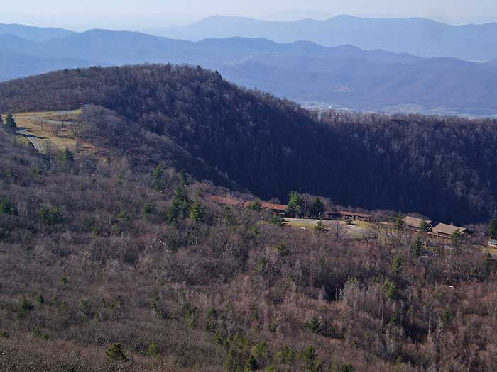
In an effort to get in some miles and solitude, we created our own 11-mile hike starting from the parking area at MP 37.8 where the Corbin Cabin Cutoff Trail crosses Skyline Drive and joins the AT on the west side of the hill. From the parking lot, we walked south on the AT beneath the Stony Man Overlook to the intersection of the Passamaquoddy Trail at the base of Little Stony Man. The views along this trail are fabulous. We skirted under the cliffs on the blue-blazed Passamaquoddy where rock climbers were just gearing up for the day. We would meet them again at the top later in the afternoon as we made our way back via the AT. We followed the Passamaquoddy all the way into Skyland where we kept following any trail (or open patch of grass) that seemed to head south until we reached the ampitheatre and the start of the Miller's Head Trail.
Climbing up over Brushytop and then down to Miller's Head, we were rewarded with excellent views, though the drains on the overlook at Miller's Head were clogged and the standing water, besides smelling ripe, was attracting way too many bugs (especially horse flies) to stay there long. We backed off a couple hundred yards to a rock outcropping on a knoll with a wonderful vista and had a brief lunch. There was only one other group on this trail, a blessing in a day of crowded trails. This little side trail (1.6mi round trip) was well worth the detour, if only for the great variety of wildflowers.
Backtracking to Skyland ampitheatre (great butterfly watching all around this area), we picked up the paved entrance road and walked southeast towards Skyline Drive, striking the AT just before reaching Skyline Drive. We headed north on the AT back towards the car, walking almost immediately through an area where the ground was littered with bushels of chanterelle mushrooms. It took every ounce of LNT training to keep the chef in me from picking a feast for dinner. Oh to have been on private property!
Our solitary walk on the AT was very brief. We came upon masses of people at the Stony Man parking lot as we walked through. Though we tried to stay between bubbles of hikers, it wasn't always possible and certainly there was no way to avoid the noise. We left the AT to climb Stony Man and despite all the people, the view was really quite fabulous. Looking south over Skyland, we could see both Brushytop and Miller's Head where we ate lunch and looking to the north, in the foreground, we could Little Stony Man lower where we were in the morning and upper where we would encounter the rock climbers again in about 20 minutes. In the background to the north, we could see the peaks including Mary's Rock heading up to Thornton Gap.
The walk from Stony Man to Little Stony Man was less crowded but still busy and we got stuck behind a threesome who would not give way on the single track. We managed to slip by them in the confusion at the post marking the intersection of the Passamaquoddy and the AT only to find ourselves behind a large group swilling beer, smoking, and generally being a nuisance. After the Little Stony Man parking area, we had the AT to ourselves for the couple of miles back to the car.
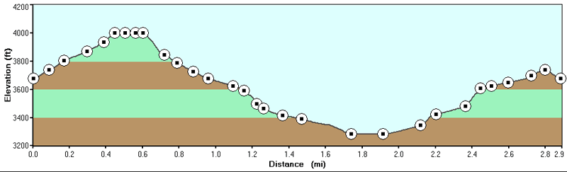
Pros: There's a lot to see in a very compact area and it's not a problem to put together a hike that suits you. The views are some of the best in SNP. There is some elevation gain but it really is gentle. The trail is rocky in places, but nothing like dozens of other hikes I could take you on.
Cons: You are not going to be alone. And even when you are alone, the AT runs right along Skyline Drive, sometimes within 20 paces of traffic.
I would do this again and again, mid-week in January!
By:Jerome
Rating:
Date of Hike: Saturday, July 16, 2016
Overall, this is a great hike with beautiful, expansive vistas and a leisurely route that's perfect for a relaxed, enjoyable day. One important caveat, however: the directions for where to pickup the trail to start the hike are not accurate. Furthermore, there are discrepancies between the hike description given on the webpage and the one provided in the PDF topo map use the website information. To pickup the trail, park at the Stony Man parking area and use the trail junction on the RIGHT side of the parking area (not the left as described above). We started on the left and ended up doing the hike in reverse... resulting in the leisurely downhill route being surprisingly uphill. Start on the right hand side and you'll have a great hike. One final note - there are other trails that connect at various points so you can add/shorten as desired once you get there (take a look at the map at the parking area).
By:Hans (und Heidi)
Rating:
Date of Hike: Friday, November 27, 2015
The Day After Thanksgiving. REI told everyone , including the employees to "go out". They did! So did we,,,,
Last time I was here here was with Armando, ( may God Bless the Soul of my Hiking Buddy). That was in 1977. I have been everywhere very near here countless times. But I came back this day. To this place. The day was perfectly clear,,, the westward view just as scenic as could be. The trail changed from when we backpacked it as teenagers. We could walk it as seniors, tomorrow ,,,,
Still a great place in the park. We will be back . Soon ,, like during the week.
By:Mags
Rating:
Date of Hike: Sunday, November 1, 2015
I started this trail at Little Stony Man parking area with my dog. I tried to follow the trail along the shorter path, to the left, to reach the summit, instead of hiking the circuit as described, as we had already hiked Hawksbill that day and just wanted a quick summit hike to finish out the day. Well, we accidentally took the wrong trail, and ended up hiking the Passamaquoddy trail. Which was fine, but a lot more time than we bargained for. At least two other groups of hikers I encountered along the way had made the same mistake, and decided to give up and turn back. One of them gave me her map after I had decided to trek on for the duration of the loop. We finally reached another parking area (the main parking lot, I assume), which was very far from where we were parked. At this point, I started seeing signs that said dogs were not allowed on the trail. The signs at Little Stony Man all indicated that dogs were allowed on the trail. I tried taking the orange blazed horse trail to the summit to obey this rule, but was not able to actually summit with my dog. At this point, we were two plus hours in to an unanticipated hike, tired, and the daylight was fading. Thankfully, a good natured family offered to give us a ride back to the other lot where my car was. Had this not been the case, we would have been in a bad spot. This would have been a great hike, but if you start from the Little Stony Man parking area, be very careful about your directions. Especially if you plan to bring along your pet.


