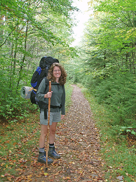
Seneca Creek and Seneca Falls make this one of the most beautiful stream hikes in the mid-atlantic. With numerous first rate camp sites along its banks, this is a definite backpackers delight. If you backpack make sure to add this fantastic hike to your list.
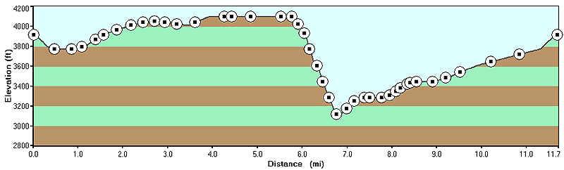
From the parking area head down the Seneca Creek Trail (TR515) 1.1 miles and turn left on the Tom Lick Trail (TR559). Ascend the mountain on what appears more of a old forestry service road than a trail before arriving at the ridge, and intersection of the Allegheny Mountain Trail.
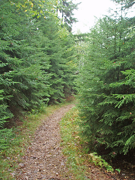
Turn right on the Allegheny Mountain Trail (TR532) and in 0.3 miles pass the North Fork/Big Run Trail on the left, then in another 0.5 miles pass the Leading Ridge Trail again on your left. Continue on the Allegheny Mountain Trail for 0.4 miles before passing the Swallow Rock Trail and great camp site at a small pass on the ridge.
Continue uphill on the Allegheny Mountain Trail then in 1.5 miles pass the Bear Hunter Trail. 1.5 miles further the Spring Ridge Trail turns left, stay right downhill through a small clearing and rejoin the Allegheny Mountain Trail on the other side of the clearing. 0.1 miles downhill the trail will split with the Allegheny Mountain Trail turning left and the Horton Trail (TR530) turning right downhill.
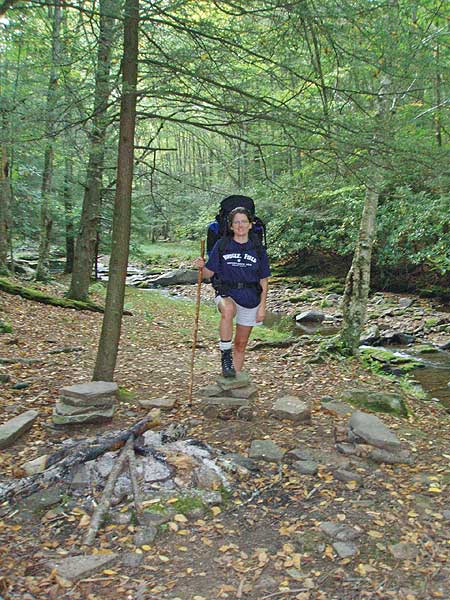
Turn right on the Horton Trail as it descends the mountain steeply for 1.1 miles before arriving at Seneca Creek. Cross Seneca Creek and climb up to the Seneca Creek Trail (TR515) on the opposite bank.
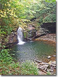
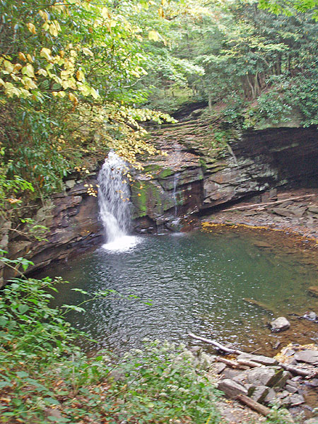
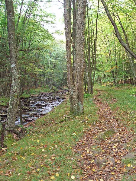
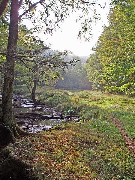
Turn right on the Seneca Creek Trail passing several great camp sites just below Seneca Falls 200 yards from where you crossed the creek. Cross Seneca Creek just above the falls and pass another fantastic camp site.
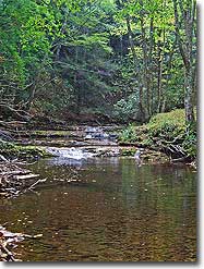
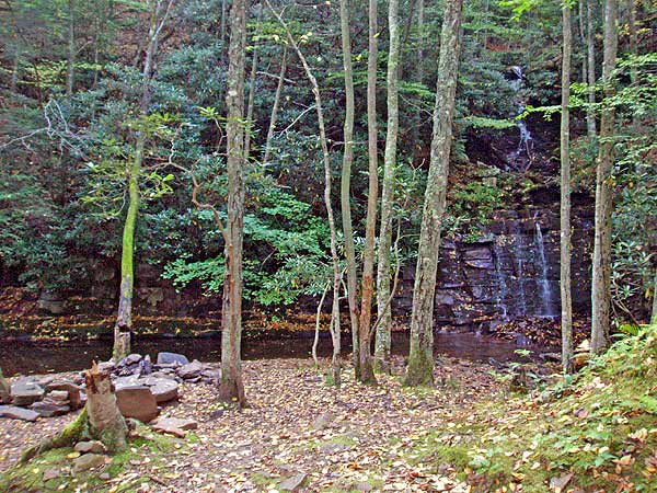
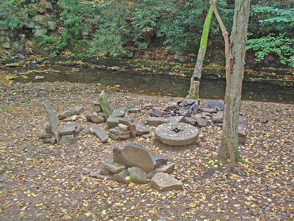
In 1.5 miles from the falls there is an unmarked trail on your left. Follow it for 30 yards to one of the prettiest campsites in the forest, with an old grist stone and waterfall on the other side of the creek.
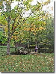
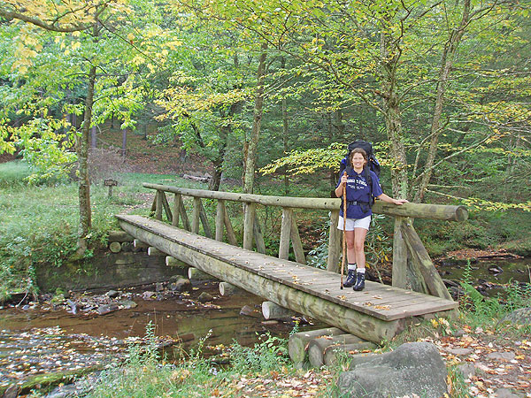
Continue up Seneca Creek Trail and pass the Bear Hunter Trail on your right in 0.1 miles, then in another 0.1 miles arrive at a clearing and the Judy Springs Campground and intersection of the Judy Springs Trail that crosses Seneca Creek on a wooden foot bridge.
Don't cross the footbridge, but remain on Seneca Creek Trail for 3.3 miles back to the parking area. Passing the Swallow Rock Trail in 1.1 miles and the Tom Lick trail in 2.4 miles.
Late September
Seneca Creek Camping
Allegheny/Seneca Creek Hike Comments
Archived Comments
By:Bruce Fleckenstein
Rating:
Date of Hike: Wednesday, November 2, 2016
Went to Spruce Lake Campground to camp the day before. It was gated so ended up staying at Gatgewood Campground. This was a nice place to camp on top on the mountain. It was close to the trailhead. After taking the first trail off Seneca Creek the trail constantly proceeds uphill. Same with the Allegheny trail. It however will climb and somewhat level off at times. this will take you to the top of a ridge where there are some good views of an adjacent mountain. The trail had some boggy spots that were manageable. The recent weather was fairly dry but could have had some past rain to contribute. The Allegheny trail starts to descend and intersect with other trails. After taking the Horton trail, we began a technical decent. down to Seneca Creek. This trail is on the side of the ridge and tends to fall of at times. It is humbling to look to the left. Use caution here. Once we arrived at Sceneca Creek the Scenery was spectacular! Soon we had to begin crossing at points. We brought crocks but I only used them twice when crossing. Was able to rock hop the other 2 or 3. Could have gotten away with using them once but I had them on when leaving camp so kept them on. There is a big water fall 15 ft+ early on. It is a great spot! I think the crossing above this required crocks. we continued on and passed several campsites. Ended up camping a bit before Judy Springs. Noted that firewood looked scarce at most sites. Camping along the creek was enjoyable. A mouse crawled across my back when I was sitting on the stone seats by the fire. It continued to bother me. Thinking it had been feed by prior campers. I tied our food up in the Y of a big tree. When I checked it the next day I found that a couple items were eaten completely. I think it was the mouse. Maybe a tree with a limb would have been better but didn't see any good options. The hike out was really nice! We side hiked the Judy Springs trail. The trail seemed to disappear. I kept following it as best I could to a nearby trail. Turned around and hung out on an outcropping above Judy Springs for a while. It was enjoyable. Continued out on a slight ascent along the creek trail that offered fairly easy terrain. The views were spectacular consisting of the creek, open areas with various vegetation and spruce thickets over the trail. Not much wildlife was seen other than a few birds, hawks? the trail is marked well with signs and the maps available will help. Thank You for the info here.
By:Fritz
Rating:
Date of Hike: Sunday, October 9, 2016
This area is a beautiful place to hike! Amazing colors in the fall! I was there a few days after heavy rainstorms (pushed up from Hurricane Matthew) had blanketed the area. The creek was running strong and there were streams and small waterfalls everywhere! And to my surprise, the meadows and Seneca Creek Trail were not too swampy or muddy. My original plan was to start at the Allegheny Mountain trail head and hike it north. But I accidentally headed northwest on the Big Run trail, as the two trail heads are very close to each other. (Be sure to read the trail sign at the trail head carefully so that you don't make the same mistake!) Once I realized my error, I bushwhacked around clockwise until I reached the Allegheny, but the area was so beautiful that I kept going and hiked through the meadows of Slab Camp Run until I reached Seneca Creek. From there, I headed north to the Swallow Rock Trail hiked northwest up the Swallow Rock (which was probably the most difficult part of the hike, due to its grade) to the Allegheny turned south on the Allegheny, and then hiked back to where I'd starting at the trail head. I camped that night - and the night prior - at Spruce Knob Lake. Very nice! I will definitely be back to camp and hike there again soon!
By:Bobby D
Rating:
Date of Hike: Friday, March 11, 2016
This is my favorite area to hike in West Virginia, and one of my favorites in the world. It has everything and is great if you want to get a first-time backpacker hooked on hiking.
I've gone in June, July, and March. I would say July is the best time to go since the huckleberries are in full bloom and you can take advantage of the beautiful swimming holes that are abound. Also, the vegetation is unbelievably lush during the wet summers.
One tip to people who are interested - There is an even bigger waterfall a mile or two down from the falls just below the Horton/Seneca Creek trail junction. I believe it is beyond the boundaries of the official trail but there is a trail that will take you all the way...just be careful crossing the very very old bridge about a half mile from the main waterfall.
I love this place. To me, it is the closest one can get to heaven on earth.
By:nate phillips
Rating:
Date of Hike: Thursday, July 16, 2015
my dad and I hiked this trail as a backpacking trip. It was very nice we loved it except for a couple of things LOTS OF MUD!!!!!!, and horse poop as well. Beautiful rivers/river crossing they where crystal clear. We camped at the best campsite in the forest BEAUTIFUL!!!!!!! there where some downed trees in the path. Bring a saw it helped us a lot with firewood its hard to find DRY wood. Overall one of the best. We have already planned a trip back.
By:Steve
Rating:
Date of Hike: Saturday, August 11, 2012
First day on the Allegheny Mountain trail was nothing special. There were periodic bogs due to several rainstorms earlier in the week. The last mile on Horton Trail drops 1,000 feet and was brutal on my knees. For that reason I would not take this loop again. Once we reached the falls it was great. It's a very pretty area with lots of good campsites. Love those stone chairs!
Hiking out the second day on the Seneca Creek trail was very nice. Water was low so we were able to do all crossing by stepping on rocks. If the water level is high I think you would need wading shoes for the two crossings nearest the waterfall. The falls/camping area and the Seneca Creek trail are why I give this hike four stars.
We spoke with a couple who took the High Meadows/Seneca Creek loop and they said the Lumberjack Trail was a boggy disaster. I prefer loops for overnight trips but next time I come here I'm just going to hike in and out on the Seneca Creek Trail maybe with some side trips to the Judy Springs and High Meadows trails.
By:Blue ridge walker
Rating:
Date of Hike: Thursday, June 14, 2012
Great hike in a new area for me. Had the whole place to ourselves until friday afternoon. Water is some of the coldest I have ever been in at the falls... Breath taking cold!
By:Mat Smith
Rating:
Date of Hike: Saturday, October 15, 2011
Ill keep this one simple
My wife and I went here for our anniversary, (!st time to Seneca Creek) It had been raining for a few days so the creek crossings were pretty deep, one was over 12" deep and 30 feet wide, with no rocks to skip over the top, but most were below the cuff of our boots, with partially exposed rocks to hop across. Again this was obviously at high water levels. Alas we pressed on.
We decided against the loop and just went down the valley and back the way we came. This was a very pleasant hike, with full backpacks for our 2 nite stay. We came in close to dusk (bad idea) and about 2mi in it got to dark to cross a large crossing, so decided to set up camp at the 1st "campsite" we say about 100yrds from the crossing.
The next morning, we broke camp headed to Seneca Falls. The best camps, with rock seats and all, are about halfway to the falls, from the route we took, at the only real clearing in the valley. We plan to get one of those next time.
The volume of water was nearly 3 times of the pics of the falls show. This tells me that if you do this hike after a rain storm, as we did, it will be pretty boggy.
Good Boots were an ankle saver, as fallen leaves on the trail hides rocks that can roll ankles easily. Along with keeping our feet dry.. until the water went over the cuffs.
Also the road leading up to the trail head, is narrow, and others on the road were traveling too fast in my opinion to avoid a collision. BE CAREFUL here, and make sure You have enough gas to get you back to the nearest station 2 hrs away on our route from I-64 in VA.
I WILL definitely be heading back in a few years with the kids, but only after checking the weather report of the week leading up to the trip
Loved all the Waterfalls, Totaling 7 of substantial size.
By:Brandon
Rating:
Date of Hike: Friday, March 18, 2011
This is an amazing hike in the spring when the water is high and tree are still yet to bloom(VIEWS). We stayed overnight in Elkins, WV the night before the hike. We took off from Elkins around 8am on Friday, and didnt have any trouble with the directions until we hit the stop sign about one or two miles before the trail head. This stop sign was the stop at which you can either go straight or turn right up the hill( basically a u-turn). We went straight first then eventually realize we weren't in the right area. Arrived at the trail head about 10am, and still only about maybe 45 degrees. Not knowing how high the water is going to be we hike for about 8/10th of a mile when we hit our first flooded creek. We eventually found a sort of dry way around the creek, turned up the trail to head up the mountain. BEWARE the water in march is only about 32 degrees. Heading up the mountain there was still quite a bit of snow but by one or so it was close to 60 degrees and beautiful. The allegheny mountain trail was really nice eventually after 5 or 6 miles we started down the mountain to Seneca Creek. BEWARE when on top of the mountain the signs are kinda tore up and the blue markers are not right at one point on the trail. Thinking about how we couldnt see the creek the first half of the hike we knew we might be in for a treat in the spring. Heading down the mountain you can here the RAPIDs of the first creek crossing. Before hit the creek you most likely will have to cross a waterfall first. Once you get to the creek you will know it. When we approached the creek we got kinda freaked out. The water was about thigh high , moving like crazy, and about 30 degrees. BEWARE this was dangerous and lucky to not lose your pack, while the water was this high. After the fist crossing we came up to Seneca Falls( absolutely amazing) in which we had to cross a second time right above the falls. For some reason all of us thought that we were done with the creek crossings on this trail, FALSE. We hike another mile or so before camping for the night, right next to the creek, that had an awesome fire place with rock chairs. Over night due to the water being so cold running under ground under the tents and the air not much warmer it got done to 25 degrees. The next morning we got the fire started again, warmed up and got all our dry gear on. We went about 300 yards before ANoThEr creek crossing with about 10-15 more after that. Awesome trip but make sure you are prepared to get wet at some point.
By:Kim
Rating:
Date of Hike: Saturday, November 20, 2010
We did this hike as an overnight backpack. FR112 is now paved all the way to the intersection with FR104. At that point it becomes gravel but is very well-maintained and was no trouble at all, even in my little Honda Civic! Day one we hiked from the trail head, up the Tom Lick trail, up the Allegheny Mountain trail, down the Horton trail, and then along the Seneca Creek trail to our campsite. Notice I mentioned "up" several times. Despite the small elevation gain, these trails just seemed to keep going up! Switchbacks were practically non-existent. Note that along the Allegheny Mountain trail, the sign for the Bear Hunter trail is practically destroyed and is marked as trail 529 instead of 531. It's correct at the intersection with the Seneca Creek trail, though. Once reaching the Creek we crossed probably 5 times on our way to camp. Water shoes are a great idea and the water is freezing! It was worth it though to camp at the site with the waterfall, "den" of tables, love seat, and fire pit, and "kitchen table" made of an old grist stone. The second day was an easy hike along and through Seneca Creek back to the car. I'm sure these trails are packed during the warm months but this weekend it seemed like we had all of Spruce Mountain to ourselves! We saw only one other person on day one and two others heading to Judy Springs while we were hiking back to the car.
By:Rene
Rating:
Date of Hike: Friday, May 1, 2009
I would agree with other reviewers that this is one of the most beautiful hikes I have seen. We had some difficulty finding the trailhead from google maps. We arrived too late to do the loop as described, so we proceeded from the parking lot down the east side of the trail toward the campsites and did an out-and-back route. It was rainy and wet. We were glad to have crocs along for the water crossings although the second day, we just went straight through the water with our hiking shoes. We were lucky to get the "prettiest campsite" with the grist mill and next to the waterfall. It was gorgeous! Two other groups were camped in the clearing.
We saw a few mice in the evening around stones by the stone chairs. (loved the stone chairs) We had a little difficulty finding privacy for bathroom needs as the trees were small and we were next to a hillside. On the second day, we left our packs at the campsite and proceeded to the beginning of the steep hill where we turned around. We really enjoyed the many waterfalls. The walk back to the campsite was even prettier as we walked upstream. Our route covered about 10 miles. Not too strenuous.


