HikingUpward Geocaching

We participate in two different types of Geocaching at HikingUpward.com. The traditional Geocaching, where we place a small container with log book, pen, and small exchange item, and the Find A Free Hiking Stick Geocaching.

Traditional Geocaching


HikingUpward Geocache
N38.99779 W77.98687
Geocaching.com: GC219EA
(map below:more info)

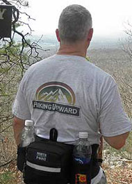
  • If you are the First-To-Find on one of our geocaches we have also included a HikingUpward t-shirt. These t-shirts are only placed in our geocaches or given away. So if you find one, take a pic and we'll add it to the 'Claimed' section of this page!

  • On hikes where we have placed traditional geocaches you will see similar information to the left on the hike pages. Enter the information in your GPS..

  • Geocache information is also available at geocaching.com for most of our caches for use with applications such as the iPhone Geocache app.

  • Format: Lat/Lon hddd.ddddd  Example: N38.68478 W78.55727

Find A Free Hiking Stick Geocaching

Over the years we have received many emails regarding the hiking sticks we use and were to get them. Hand crafted and personalized by a couple in Missouri they market them under the name "Wilderness Walker", you can purchase them on eBay. They will last a lifetime with proper care.

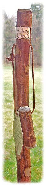
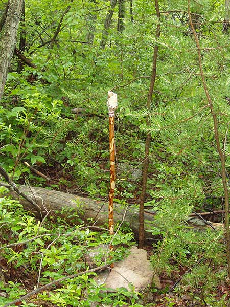
To have some fun we are 'planting' brand new personalized 'Hiking Upward' sassafras sticks on some of our longer hikes. Find one and keep it for free! Here is an example of what a planted stick looks like.

Note: Only the hikes with 'Find A Free Hiking Stick On This Hike!' log/lat information located on them still have, to the best of our knowledge, hiking sticks. Sometimes a hiking stick has already been found and the person forgot or hasn't been able to email us yet so we could remove the info from the page ... sorry we can't guarantee they're still there.

Sorry, all the hiking sticks have currently been claimed. We will be putting some more out soon!

How To Participate:

  • Anyone can participate! Plot the hiking stick grid coordinates located on the hike page into your GPS. If you are using a map only and not a GPS make sure the map uses the WGS84 Datum.
       Format: Lat/Lon hddd.ddddd  Example: N38.68478 W78.55727

  • The hiking sticks are 'planted' in an upright position (example) no more than 100 yards off the hike trails. However, they are not visible from the trail itself, you need to be within 10-15 feet to be able to spot them.

  • One per person please. If you've found and claimed one already please don't remove any others, we would like as many people as possible to be able to participate. It's obviously the honor system.

Note: Use caution when leaving the trail as Timber Rattlesnakes are hard to spot it the brush and if you are not comfortable leaving the trail and finding your way back please use common sense and don't participate.

If you locate one of the hiking sticks:
  • Take it, it's your to keep for free! Then please drop us an to let us know you located one so we can remove the hiking stick info from that hike. We will then plant another hiking stick somewhere else on the same hike.

  • It's important that you let us know you found one so someone else isn't wandering around looking for a stick that has already been located.

  • Also you can a photo of you and your new hiking stick and we'll post it on the web site.

If you get to the GPS location and can't find the hiking stick:

  • Make sure you have the correct and complete log/lat setting in your GPS with the Datum of WGS84. The log/lat should be in the format N38 36.771 W78 17.439 (example only)

  • If you are sure you entered the information into your GPS correctly and you were at the exact location most likely someone has already found that hiking stick and forgotten or hasn't been able to email us yet so we could remove the info ... sorry we can't guarantee they're still there.

  • Also, please send us an so we can remove the information from the hike page until we confirm it's gone and plant a new one at a different location on the hike.
2009 Claimed:

Hike: Apple Orchard Falls
Found: May 29, 2009

Sam was up from South Carolina visiting his son at school, and found this hiking stick we had just planted a couple of weeks before on the Apple Orchard Falls hike.

Apple Orchard Falls is one of the prettiest stream and waterfall hikes in the Virginia's.

Hike: White Rocks
Found: July 11, 2009

Mathew found a stick we had planted on the Racer Camp Hollow Trail back in May.

The section of the GWNF has some of the best hiking in the northern section of VA/WV.

2008 Claimed:

Hike: Duncan Knob, GWNF
Found: August 15, 2008

Larry, his wife, and three sons, found this hiking stick on the Duncan Knob hike we had planted just a couple of weeks before.

Larry mentioned the gang also got to enjoyed the blackberries that are prevalent in this area.

Hike: Trimble Mountain, GWNF
Found: August 10, 2008

Mike and Jill, along with their two dogs Roger and Chase, locate this hiking stick we planted in June on the Trimble Mountain hike.

Mike also mentioned that they say quite a bit of wildlife, including a bear cub, deer, and a black snake.

Hike: Austin/Furnace Mountains, SNP
Found: June, 2008

Robert and his boys were out on this tough hike in the Shenandoah National Park and found this stick we had planted just the weekend before.

The crew also got to enjoy some of the abundant blueberries that grow in the park.

Hike: Little Schloss, GWNF
Found: May, 2008

Will and his two kids hiked the Little Schloss circuit, and found a stick we had planted in April 2008 on the Little Sluice Trail.

Little Schloss is one of the less traveled hike in the Great North Mountain area, and has some of the best views of the shenandoah Valley from the Little Sluice ridgeline.

2007 Claimed:

Hike: Duncan Knob
Found: April 21, 2007

Jack located one of our hiking sticks that we planted on March 24th this year.

Hike: Buzzard Rock, GWNF
Found: June 3rd, 2007

Tim found this stick on the Buzzard Rock Hike in the GWNF the first time using a GPS and Geocaching.

Tim also said it was a rainy soggy day on June 3rd, but he still had a great hike, and enjoyed the geocaching.


2006 Claimed:

Hike: Trout Pond, GWNF
Found: April 30, 2006

Herb was out enjoying the the great day with the family on the Trout Pond Hike and located the first stick we had planted in 2006, on March 11.

It looks like Cruizer, Herb's dog, was ready for a rest at the Lina Constable Overlook. The ascent from the lake to this point is the steepest part of the hike.

Hike: Halfmoon Mountain, GWNF
Found: July 16, 2006

Woodstock hikers Grace & Tim found a hiking stick we planted April, 5 2006.

This hiking stick had been out for a while in a lot of rainy & snowy weather since being planted.

Hope it was still in decent shape guys!

2005 Claimed:

Hike: Halfmoon Mountain, GWNF
Found: July 2, 2005

Kyle found this stick we had planted on April 6, 2005 on one of the first GWNF hikes we did this year. Here is Kyle's review of the hike:

This is a good hike with several sections that will elevate your heart rate a bit. It starts off rather quietly as you meander down a service road. The grass is starting to get knee to waist high in many areas on the road so be sure to do a tick check periodically. I had a few but they were still moving north when I found them. The creeks were low but still wet. The German Wilson Trail sign has sustained some damage and is not of much use as there are no arrows on it anymore. Watch closely for the markings. The trail itself will make you rethink your physical condition for sure. It is like walking stairs that are a mile long. There are several areas where the ferns have grown over the trail and rocks making it hard to see where and what you might be steping on. Watch your step. The view on the top is wonderful and the trail after the summit is nice and uneventful. It is also downhill...... There is wildlife as I saw a number deer and several turkey. I would do this hike again. The only thing it is missing is a swimming hole.

Hike: Veach Gap, GWNF
Found: July 16, 2005

Matthew found this stick we had planted early in 2004. Unfortunately, it was the last one out there that we hadn't protected with polycrylic as we do now.

The moisture had got into the wood over the summer than obviously cracked when it froze last winter.

Sorry Mathew! All the new hiking sticks should be in good shape!

Hike: Signal Knob, GWNF
Found: May 7, 2005

Greg while hiking with Mike from midatlantichikes.com and the Howard County, MD chapter of the Sierra
Club on Massanutten Mt found this Sassafras walking stick placed there by us last summer.

Hike: Falls Ridge, GWNF
Found: May 28, 2005

Steve found a stick while doing the long loop hike along Falls Ridge on the south portion of Great North Mountain

Here is an excerpt from Steve's email of the hike:

'I located the stick at N38 52.959  W78 45.774 today. It’s was camouflaged by the leaves where I found it and really weathered but I’ll clean it up. I’m quite attached to it already after using it to descend the pipeline.'

Hike: Laurel Run , GWNF
Found: April 9, 2005

Mike, a scout in Troop 1352 from Occoquan Virginia was on a practice hike for a trek later in the year in New Mexico and found a stick we had planted on March 26 this year.

Hike: Sugar Knob , GWNF
Found: April 14, 2005

Abe & Melissa found a stick while doing a circuit 3 day hike of 30 miles.

Here is an excerpt from Abe's email of the trip:

'...I started at the Little Stony Creek Parking area,  hiked to the cabin on Thursday.  On Friday I started at the Cabin turned left to the Halfmoon trail (I passed right by your Halfmoon stick) then to the German Wilson Trail, Old Mine Trail, Wilson Cove (I knew I was getting close when I saw the wooden foot bridge) Then I found it!!!.  Continued up the Old Mail trail, to Racer Camp Hollow and back to the cabin.  I packed up on Friday and went back to the car via the Mill Mountain Trail to the Big Schloss cutoff.  I logged just under 30 miles for the 3 days.'

2004 Claimed:
Hike: Mill Mountain, GWNF
Found: May 29, 2004

Mark found one of our 'Hiking Upward' sassafras sticks while on a back packing trip in the Mill Mountain area of the George Washington National Forest over the Memorial Day weekend.

Hike: White Rocks, GWNF
Found: May 2004

Steven hiking with a group of friends found this 'Hiking Upward' stick on the White Rocks hike on Little Sluice Mountain in the George Washington National Forest. It was planted about half way along the Old Mail Trail.

about us | home page | terms of use | © 2000 - 2010