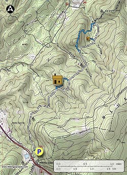
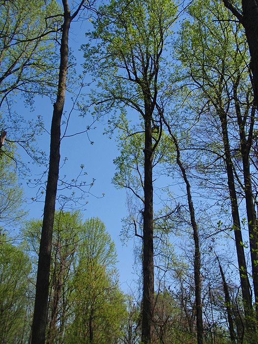
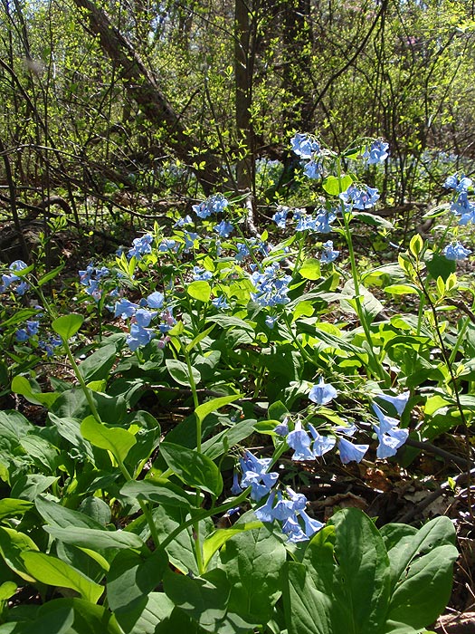
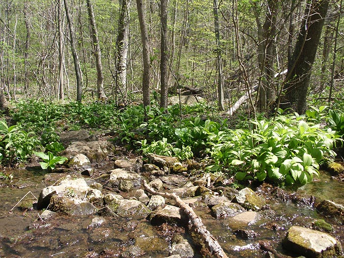
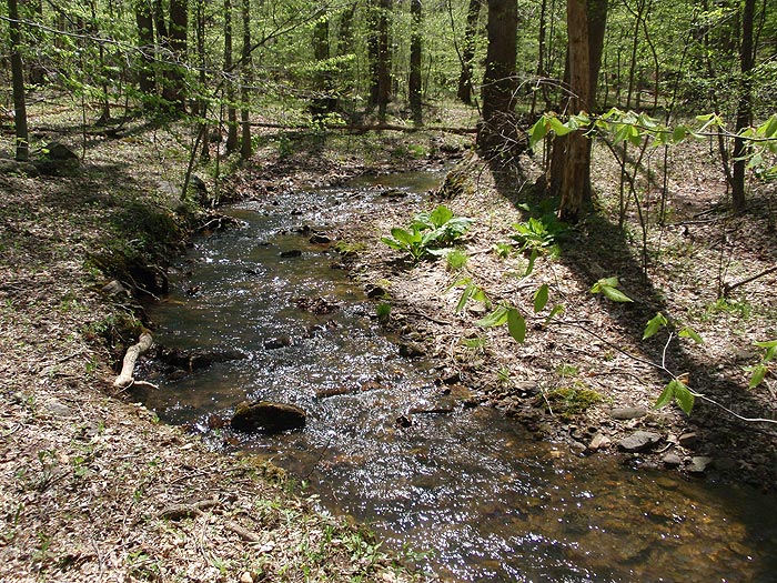
Another nice spring or fall hike closer to the DC Metro area. This is a out and back hike with two side loops, the main features being the small mountain streams, wildflowers, Myron Glaser Cabin, and the Rod Hollow Shelter. The best time to do this hike is springtime when the wildflowers are out and the streams are at their fullest.
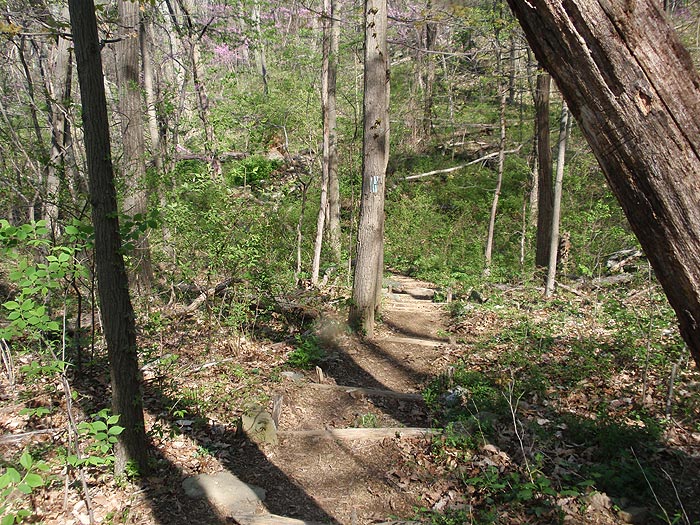
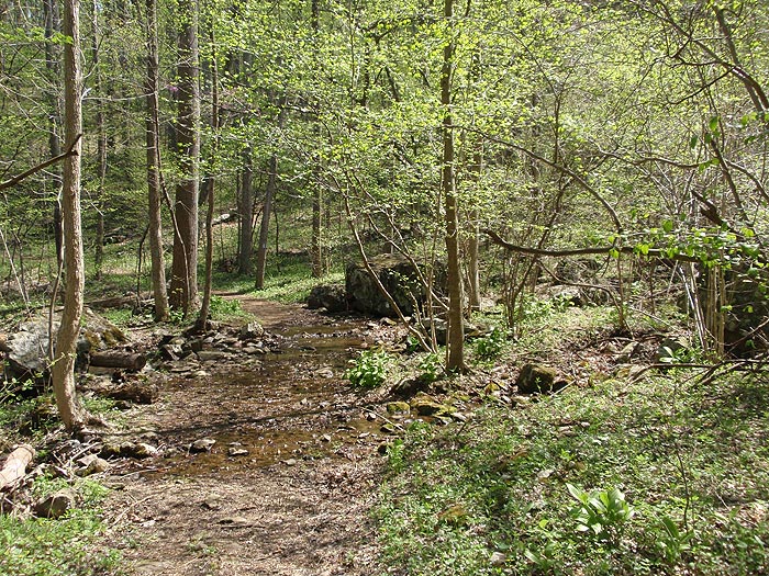
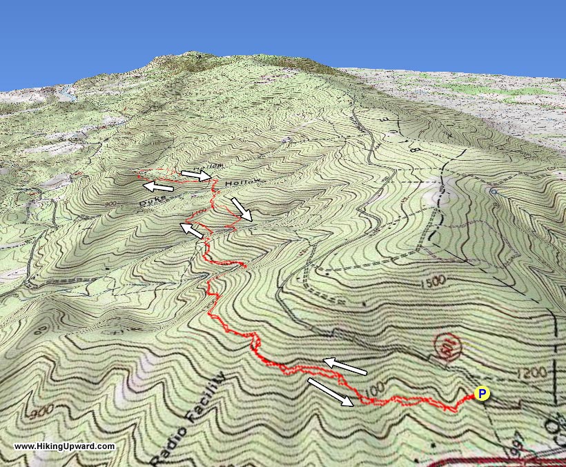
From the parking area on VA601 follow the blue blazed trail down from the end of the parking area for 0.1 miles to the intersection of the Appalachian Trail (AT). Turn right uphill/north on the AT as it passes over the first of four ridges, cross a small stream, pass over the second ridge, then arrive at the blue blazed trail that makes a side loop to the Myron Glaser cabin.
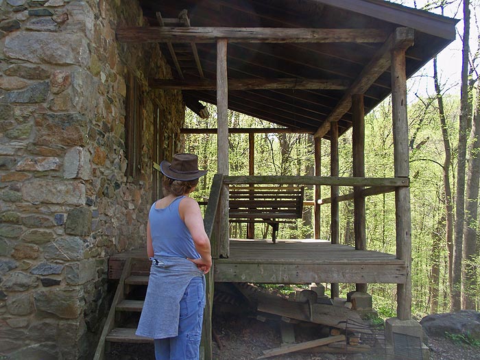
Turn left downhill on the blue blazed trail where it shortly joins a small road and turns right. Cross another stream and walk up to the Myron Glaser cabin. The cabin is maintained by the Potomac Appalachian Trail Club and is available for rental to PATC members only. The blue blazed trail passes around the back of the cabin and climbs back to the AT in another 0.2 miles.
Turn left on the AT crossing the next ridge and descending through Duke Hollow. After crossing the stream in Duke Hollow it will be another 0.4 miles to the Fisher Hill Loop Scenic Trail. The trail passes over Fisher Hill without any vistas, and is more of a scenic walk in the woods. Turn left on the blue blazed Fisher Hill Loop Scenic Trail as it passes over the top Fisher Hill then descends and rejoins the AT in 1.0 miles.
Turn right/south on the AT for 0.4 miles to the junction of the Rod Hollow Shelter. The shelter is 0.2 miles from the AT and usually has a good water source next to the stream in Rod Hollow. Continue south on the AT passing the the Fisher Hill Loop Scenic Trail in 0.4 miles you ascended earlier.
From this point you can follow the AT the 2.9 miles back to the parking area blue connector trail, or retrace your hike back past the Myron Glaser cabin.
Late April
Ashby Gap Hike Comments
Archived Comments
By:Curtis
Rating:
Date of Hike: Sunday, September 17, 2017
I have walked this trail twice now. The first time was about 3 weeks ago. I was followed by horseflies for miles, stung on the head by a bee, and ended up with poison ivy on my ankles. We went again today and everything was going good until mile 2.7 there was a bee nest in a hole in the ground right on the trail (100+ bees around the opening of the hole). I didn't even see it, walked right past it, but my g/f and dog ended up getting stung multiple times each. Then we had to forge a trail through the woods to get to the other side of the hive. so I've struck out twice now. I think this will be a good walk in fall and winter though when all the bees are gone. Not sure if ill go back for more punishment though. Think ill just try a new trail.
By:Ash
Rating:
Date of Hike: Monday, July 17, 2017
On this day I wanted a well maintained "easy" hike and this met my needs. Easy is relative, however the easy part for me was not too much elevation change, no long rocky sections, no very steep inclines or declines. The first 1/2 mile is full of road noise but after that it is nice and quiet. I would hike this again.
By:Sean
Rating:
Date of Hike: Tuesday, May 2, 2017
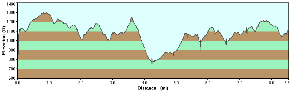
A few dogwoods and many wildflowers in bloom. Ran into about 10 serious AT hikers, with several staying in the shelter. Wasn't sure about the relatively large (for me) elevation increase but, as you can see from the profile, the increase is not all at once and thus wasn't bad. A few times on the steepest slopes I stopped to catch my breath a few times. I like hikes that include the AT as a portion because in this area it is always in fair to excellent shape. The blue-blazed trails are rockier and narrower, also more isolated as the AT hikers stuck to the AT. I sat at the cabin on the swing by myself for a while. The Fisher Hill Loop Scenic Trail had a surreal aspect with very long views through the trees (no "vistas") and wide slopes you don't see on the AT portion -- it is a real change of pace. Many streams to cross along the whole way. It was relatively dry and I didn't need my hiking pole I had packed in my backpack. There is a lot of variety and many things to like about this hike. This is one I'd do again.
By:Jen M
Rating:
Date of Hike: Friday, April 28, 2017
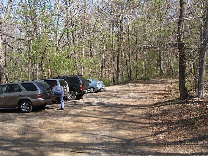
Not a bad hike. I wanted to get out of the city and let the dogs off-leash, so it certainly met those criteria with a reasonable drive to squeeze in on a Friday. Parking area was really hard to see (gps is spot on, it's just really, really hard to see). Trail is very well marked. With all the rain we crossed over a handful of streams and the dogs were plenty muddy!
By:Van
Rating:
Date of Hike: Saturday, February 25, 2017
Great Hike
Read my full review here:
http://vanjohnson907.blogspot.com/2017/02/ashby-gap-hike.html
By:Steve from Winchester
Rating:
Date of Hike: Wednesday, December 7, 2016
Contrary to a lot of the feedback, I really enjoyed this hike. You cross several streams and ridges and the trail is well marked. Given the rain of the prior day, the streams were flowing well and required several minor crossings. I can see this being a great Spring time hike for wildflowers given all the water crossings. The Fisher Loop Scenic trail was very nice except you had to watch out for the rocks hidden under the fall leaves - especially on the downhill portion prior to it joining back up with the AT. I will definitely come back and do this hike in the Spring.
By:Dan
Rating:
Date of Hike: Wednesday, July 20, 2016
If you really enjoyed the part of The Hobbit where the dwarves and Bilbo travelled through Mirkwood, or if the idea of vacationing on the Forest Moon of Endor holds a lot of appeal for you, THEN THIS IS YOUR HIKE! Otherwise this is a long, somewhat monotonous walk in the woods. It might be better in spring when there are wildflowers.
By:Henrietta the Hale Hiker
Rating:
Date of Hike: Saturday, October 17, 2015
This was not an overall strenuous hike. We finished up in about 3 1/2 hours. The hike itself was fairly flat. The downside of this hike was the high number of people and dogs we encountered along the way. There were folks staying in the cabin and camping at the shelter. We also ran into folks and their pups roughly every 20-30 minutes, whether we were passing them or they were headed in the opposite direction. Quite a few of the hikers were 60+ which gives you a good indication of the actual difficulty of the hike. It was more an issue of distance than difficulty. All that said, it was still a nice hike and great to be outdoors in the fall. There is not much to see but the leaves made up for it. Hurry before they are gone!
It's a quick drive from the DC/NOVA area. The parking lot is hard to spot from the road so I would make sure to turn on your GPS so as not to miss the turn. If you're in the area, I would recommend grabbing some food and/or beer at Hunter's Head Tavern. It's roughly 10-15 minutes away and worth the trip.
By:Matti
Rating:
Date of Hike: Monday, June 29, 2015
What made this hike so amazing was that for me it was the perfect combination of length and ease. It was long, so I was able to get a good day out of it, but it's just south of the infamous Roller Coaster section of the AT, so although there's obviously still a fair amount of elevation change (it IS the AT), it's not brutal like on the RC. There was lots of variety on this hike it felt like the vegetation was changing every 100 yards or so. Definitely take the little loops out to the cabin and the "scenic" Fisher Hill. The cabin is adorable and has a nice swinging bench on the porch--you might want to save it for the hike back and have lunch there, as there's a picnic table as well (of course this depends on whether anyone's staying there--no one was when I came across it) and an adorable outhouse. The Fisher Hill loop IS scenic in the sense that it's got vegetation changes, but as the description above states, there aren't really any views. I met a lot of thru-hikers on this day and chatted with a few of them I always get inspired by them. Awesome, awesome hike!
By:geomommaj
Rating:
Date of Hike: Monday, July 15, 2013
I enjoyed the warm hike today. The AT is labeled with white blazes (not mentioned in the hike description) and the blue blazed Fisher Hill Loop Scenic Trail is very overgrown. We opted not to hike along it since there were so many brambles and plants constantly blocking the almost overgrown path. Instead, we continued on the AT so that we could visit the next shelter which is maybe 3/4 mile (?) from the Fisher Hill Loop Scenic Trail sign. We met about 5 through hikers today, all but one going north. I didn't realize that the rollercoaster part of the AT is the next section on the AT to the north of the shelter. We followed the plan for the Ashby Gap hike, but one day, I want to say I've done the rollercoaster too. The parking lot was a bit challenging to find. It is unmarked and drops steeply from the entrance off of SR 601. We stopped for a few minutes at one of the creeks to soak our feet. The hike took us (48 and 50 year old women plus my 11 year old son) 5.5 hours which included some visiting with AT folks, lunch, and soaking our feet. It was very pleasant. I forgot to mention that the wild raspberries were out in abundance today. I snacked all along the trail.


