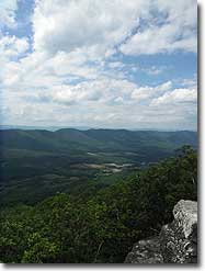
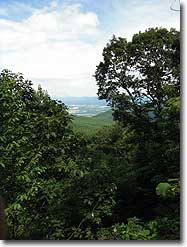
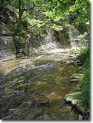
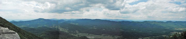
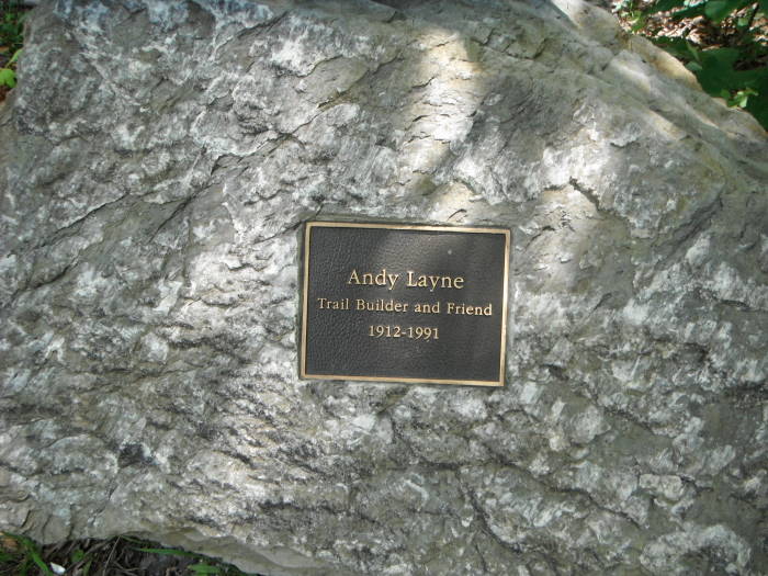
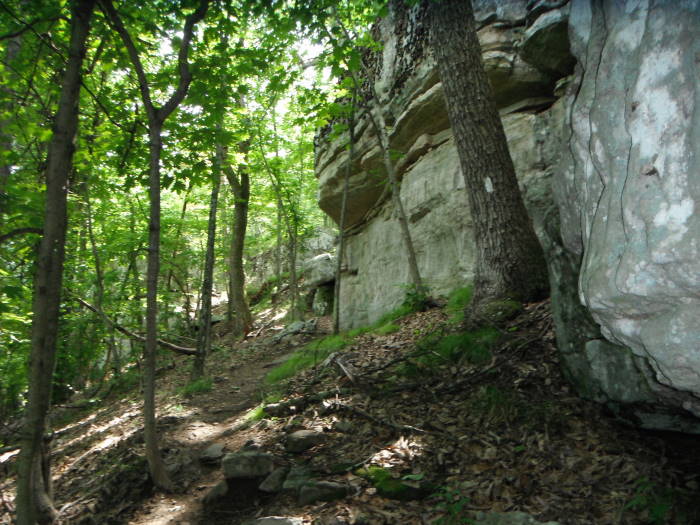
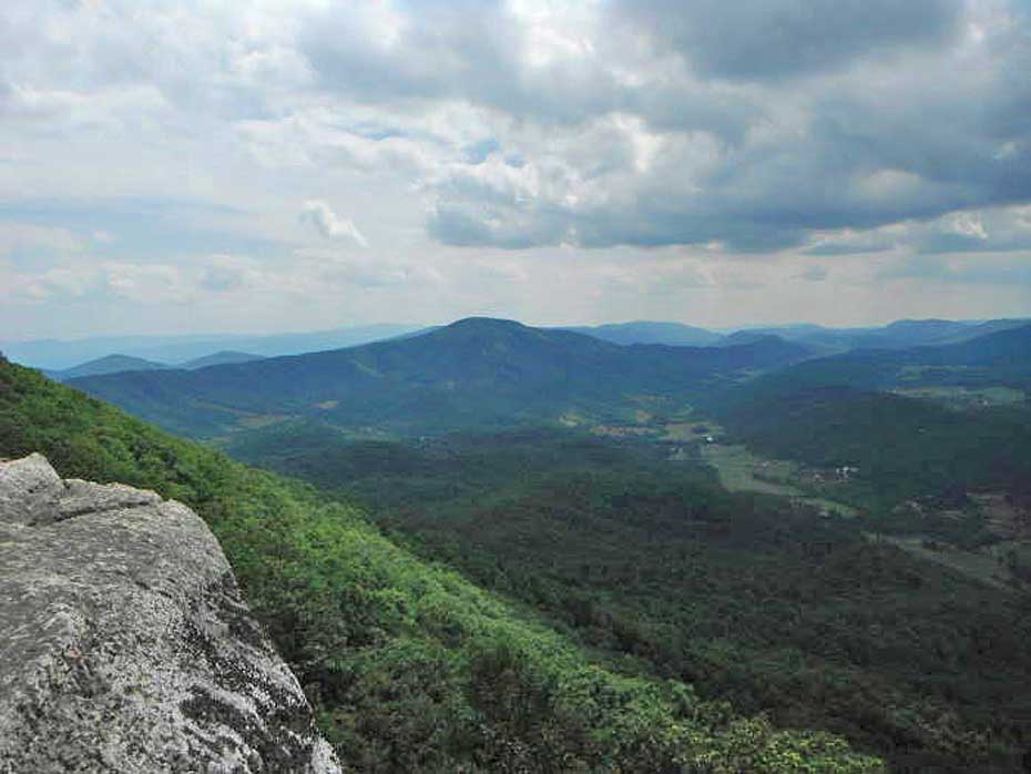
Outstanding views, a tough climb, a cool creek cliff face, wobbly bridges, Scorched Earth Gap, and The Murder Hole are just a few reasons to hike Tinker Cliffs via the Andy Layne Trail. We were so close to this trail when we hiked Carvin Cove/Hay Rock that we knocked this hike out the same day. Tinker Cliffs is the third leg in the Triple Crown of great views/hikes in this part of Virginia, along with McAfee Knob and Dragons Tooth.
Please Note:During the last several years the the Tinker Cliffs area has seen a significant increase in hiker traffic. Please follow the Leave-No-Trace hiking etiquette. There are unique rules regarding group size, and camping for this area. Please visit the Roanoke Appalachian Trail club page for full rules and regulations.
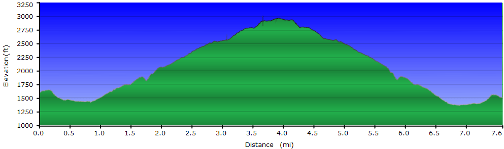
It's around 3.8 miles to the top, but be prepared for an exhausting trek. You'll go through Scorched Earth Gap to get there, then look down on the valley where the Murder Hole cave is. Read the stories linked above about how they got their names, very interesting.
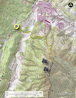
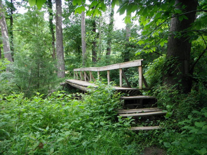
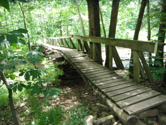
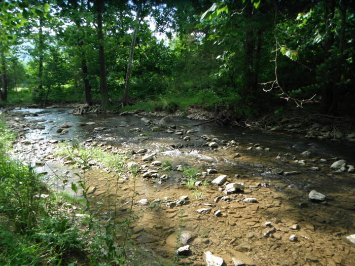
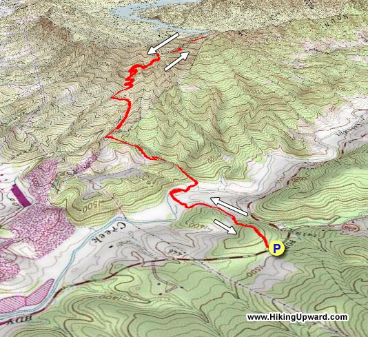
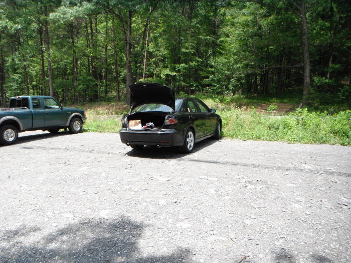
Mile 0.0 – The yellow blazed Andy Layne Trail begins at the rear of the parking area on Route 779 (Catawba Road). You'll cross two fence stiles before reaching the first of two bridge crossings of Catawba Creek. In some places over the next mile the trail was overgrown but manageable as of 2011. The first couple of miles you will hear the hum of the Roanoke Cement Co, this is their land they have generously allowed hikers to cross, so to get to the top you will just have to put up with the noise :)
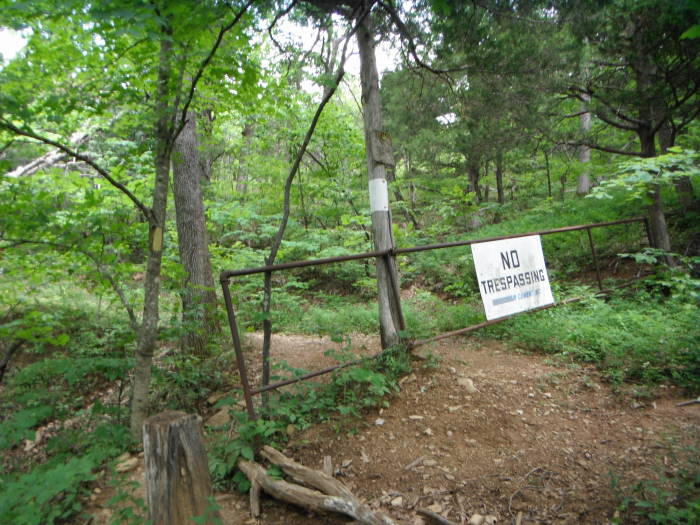
Mile 1.2 – Arrive at the gate, and as long as you stay on the trail you are granted permission to go around the “No Trespassing” sign from the Roanoke Cement Co. The trail bears to the left around the gate, and in 100 yards bears to the right. The next portion begins the tough part of the hike, gaining 900ft+ feet before reaching the Appalachian Trail. One section has no switchbacks for about 0.4 miles.
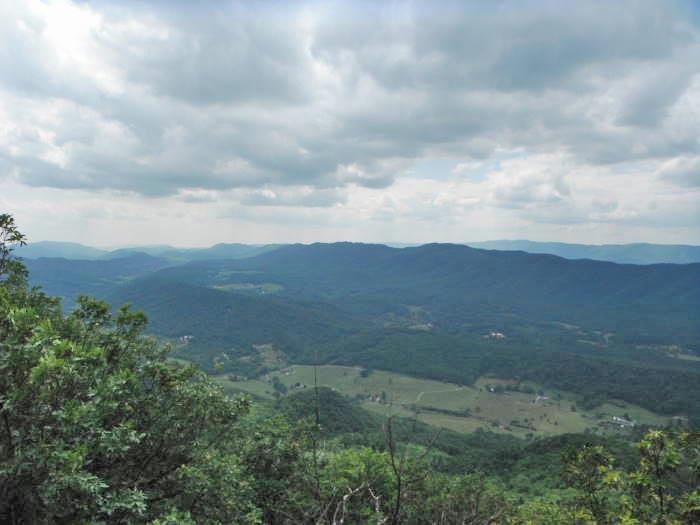
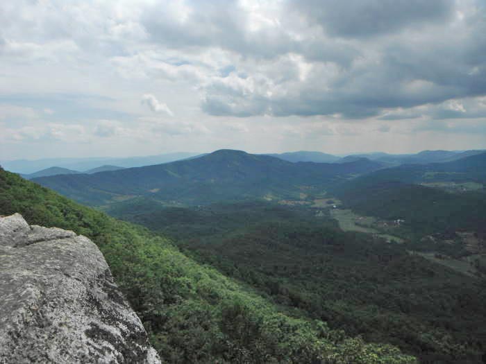
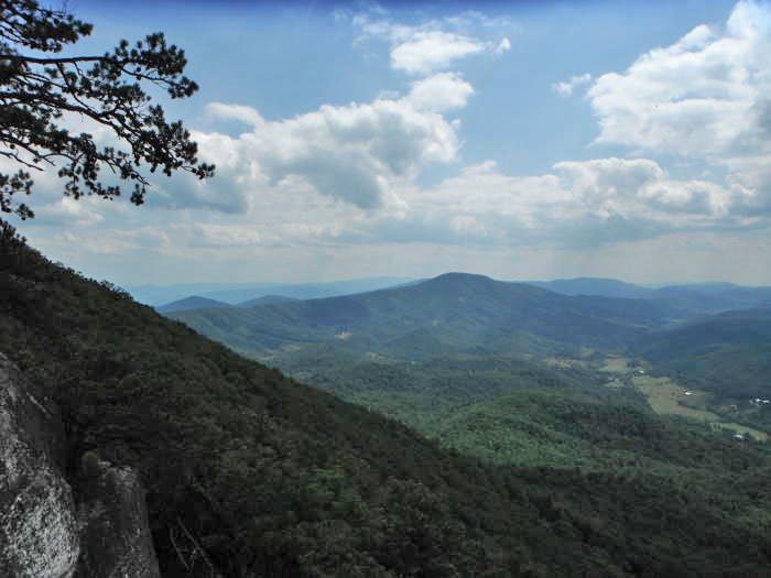
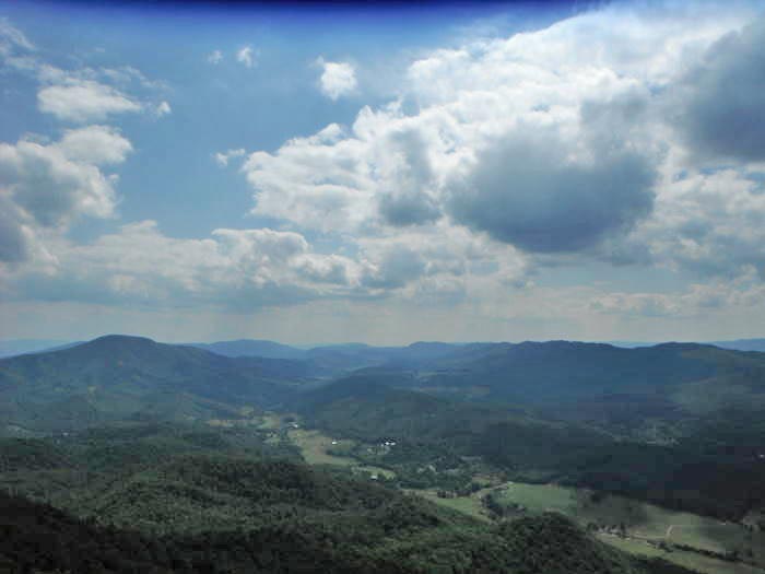
Mile 3.0 – Reach the white blazed A.T. and stay right/south, this area is referred to as Scorched Earth Gap. Continue 0.6 miles south on the A.T. for a beautiful view to the north.
Mile 3.6 – View to the northwest of Broad Run Mtn and to the Northeast of Fincastle.
Mile 7.7 - Retrace your steps to return to the parking area.
Note: If you're adventurous and need more miles, you could continue south on the AT to McAfee Knob, this would be approximately 18 miles roundtrip from the Andy Layne parking area.
Late June
Tinker Cliffs
Tinker Cliffs/Andy Layne Trail Hike Comments
Archived Comments
By:no_trail_name
Rating:
Date of Hike: Saturday, October 12, 2019
I began an overnight, group backpacking trip to Campbell Shelter/Pig Farm Campsite, (AT mile 714.2) and onto McAfee Knob, (AT mile 713.6). This was an out and back hike of approximately 18 miles. My group consisted of two families with children, so the adults were carrying 30-40 lbs, kids were 20 lbs and under.
We arrived Saturday morning around 7:30 am, all parking spots in the gravel were full and we made a spot in the grass. There may have been room for 5-6 more vehicles. Arrive early or on the weekday to avoid parking issues. Also, if you drive a car that does not have ample ground clearance, expect to drag the undercarriage entering the lot from the paved road.
Like other reviewers say, the trail starts out innocent and easy, but then it gets difficult. The stairs are especially tough with a heavy pack on your back. For a day hike or a 4-6 mile day it wouldn't be too bad, but if you plan on going past Tinker Cliffs and onto Campbell Shelter, get your hiking legs ready.
We saw countless people on the trail both days. If you're looking for solitude, this isn't your destination. If you're looking for a spectacular view and some good exercise, this is for you.
For those of you reading this and planning on doing the same hike we did by starting at Andy Layne and overnighting at Pig Farm/Campbell shelter:
-Watch out for a bear in the morning. It isn't shy and will get as close as 20 feet to your campsite. This bear circles both camping areas around sunrise looking for scraps left behind by those choosing to leave a trace. There is a large bear box in front of the shelter I would advise using. Also, campfires are allowed only in the two designated fire rings.
-Expect busy. I would estimate 40-60 campers scattered about the two areas this weekend. It felt like a state park campground.
-The hike back from McAfee Knob to Tinker Cliffs and onto Andy Layne Parking area is about 9 miles of steep ups and downs. Know your level of fitness and consider coming from McAfee Knob parking area if this is too much.
-There is no camping allowed anywhere but the shelters and area surrounding the shelters or Pig Farm Campsite.
-Water is scarce. The spring at Campbell was producing water, but very slowly. There aren't any water sources from Andy Layne to Tinker Cliffs so bring some.
By:Chris
Rating:
Date of Hike: Sunday, September 15, 2019
New to hiking but enjoy the solitude and exercise so....I started solo about 7:45 Sunday morning but had two gents behind me which I could hear at intervals so that was cool because bears do make me nervous. I figured this would be a workout and I was right. The trail was well marked so no issues there. I thought there was a steep downhill after just getting started that would suck on the way back(it did). Crossing the pastures and bridges was pretty cool. I thought the steps I read about weren't as bad as advertised (wrong steps) so I was confident. Not much for scenery in my opinion just a good trail to walk. Nothing exciting until I saw the "Stairway to Heaven". Ouch, wow, etc. It's actually two series of steps. Once I made it past those I felt some accomplishment. I enjoyed the switchback part after that as it made the climb not so bad. Made it to the scorched earth section and thought that part was really cool. From there only a half mile until the cliffs. I thought there was a pretty steep incline until you cross through the rocks (that and stairway were the worst part) but it was getting to the viewpoint after that. Pretty foggy when I got to the overlooks but still pretty awesome. I only stayed long enough for a sammie and a selfie and headed back down. The return trip was uneventful except for the cow on the trail about half a mile from the parking lot. The cow didn't scare me but he had a lot of flies with him so I ran which was the part of the incline I dreaded earlier. Animals- few squirrels, three dear, one bear (not visible but you could tell by the sound made running away). People- passed two people coming down just before I got to scorched earth. A group of four came from the AT while I was enjoying the view as well as the two guys that started when I did. Probably passed 10 people on the way back. I did this for exercise and will do it again at some point just to tackle the stairs again. Was back in the parking lot by 11:30. Glad I did it !!
By:John
Rating:
Date of Hike: Friday, August 9, 2019
1) Hike was moderate difficulty for us. Most the way up consists of a moderate slope although there was one section that was far steeper (with built-in steps). Even though this hike is a bit shorter than McAfee's Knob, we thought it was a touch more challenging.
2) Scenery was pretty at the bottom (crossing the first two bridges/creeks and walking through the field/meadow) and at the top. On the way up, the scenery was okay but not a lot of views.
3) Wildlife: saw three nonvenomous snakes, a hawk, and four black bears. First bear was a cub -- we did not see its mother. Towards the bottom, we spooked a mama bear and her two cubs. We were within 20 feet and she got up on her hind-legs but backed off after her cubs retreated. Good reminder to have a bear bell, whistle, or some other noise-maker on the trail.
4) Traffic: we went today, late Friday morning / early afternoon, and there were not a lot of other people on the trail. Maybe four of five other small groups.
5) Good hike, nice way to spend the day, but probably a one-and-done for us.
By:Wild Things
Rating:
Date of Hike: Thursday, July 18, 2019
I'm not sure why people are saying this wasn't tough. I definitely thought this was the hardest of the Triple Crown hikes. We did Dragon's Tooth on Tuesday, McAfee Knob on Wednesday and this one on Thursday. 3 hikes like this in a row is pretty tough. The stairway was never ending, but we did it! Our total overall time was 6 hours. It was also like a million degrees out, so that didn't help. The cows had escaped their pasture so the farmer was busy trying to get them all back in and was fixing his fence.
By:DC Turtle
Rating:
Date of Hike: Tuesday, April 30, 2019
The trail is a bit easier than when this description was posted. Bridges have been stabilized and steps as well as switchback added to the climbing portion. Views are amazing. On a good day, you are looking directly at McAfee Knob and then off in the distance you can see Dragon's Tooth. Have done this hike many times and never tire of it.
By:Doug Thompson
Rating:
Date of Hike: Sunday, July 8, 2018
Don't rely on the published directions to find the parking lot. On Hwy 779, drive past the notated parking lot about 1/2 mile. After crossing a narrow bridge, the parking lot will be up the hill on the right. It is small, but well marked.
By:VACBayliss
Rating:
Date of Hike: Saturday, June 9, 2018
#1 Use the coordinates provided on the site. If you don't and you just type 'Tinker Cliffs' into your iPhone map, you'll end up about 6 miles away from the actual parking lot.
Finally finished the VA triple crown. Saved this one for last. Definitely the hardest of the three. Great views at top. Saw wildlife, snakes, deer et. more. At the start of trail followed one of the local cows for a while which was humorous to the party. Trekking poles recommended and a lot of water!
By:MRS
Rating:
Date of Hike: Sunday, March 4, 2018
I love this hike. The first time I hiked Tinker was Nov. 1, 2015, And it was the final hike in the triple crown. The fall colors were amazing. It was peaceful and we saw 6 other people. This time it is the second hike in triple crown, we did Dragons Tooth a few weeks ago and will be doing McAfee next, we started out with 6 cars in the lot, came down 4 hours later to a totally full lot! I was amazed how many people were going up as we came down! This hike is great, it has ups and downs and flats, cow field, bridges over streams, stairs, steeps, and it is varied, you go up a little down a little, along, up gradually, up sharply, then more gradually etc. the top has amazing views and we saw 3 hawks. The wind had a bite so we did not linger too long at the top, we took 4 hours total and are slow and steady hikers.
By:ACF
Rating:
Date of Hike: Tuesday, November 28, 2017
My favorite overall hike in the area. Great workout and never crowded. Beautiful day today. It was alarming that I heard a couple of rifle shots at the beginning of my hike. Came across a hunter a few yards off the trail around mile 2 of Andy Layne (where you cut right and the trail widens for a spell). I plan to wait until hunting season ends before doing this hike again.
By:Jack Crow Ratcliffe
Rating:
Date of Hike: Friday, June 2, 2017
Last of my trails for the Triple Crown. One Tough Hike for a ole man of 70. But I loved it ! I wished I had done this one first because I rate it as the most difficult of the three hikes. It is well maintained by the Trail Club that cares for it. I would say the views in Fall will be Fantastic for pictures. I took my camera and do a lot of photography but I'm One & done for these three hikes. If anyone is planning the Triple Crown, do this one first, Dragon Tooth second. Save the McAfee Knob for last . Because it will be your cake walk. I hike all the time, so I will be back out tomorrow !


