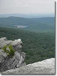
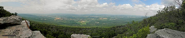
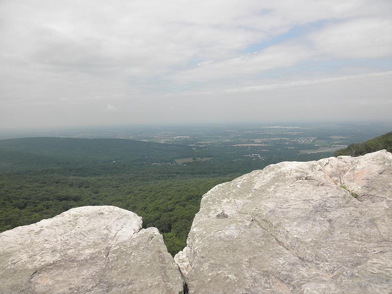
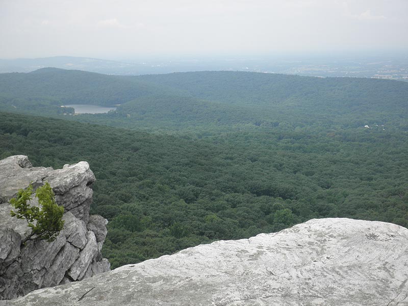
The Annapolis Rock/Black Rock Cliff hike on the Appalachian Trail, is one of the most popular in Maryland, and for good reason. The views from both lookouts are spectacular on a clear day. From Annapolis Rock the vista is to the southeast and Greenbrier Lake, and from Black Rock Cliff a 180 degree panorama west.
Annapolis Rock is also a popular camping area, with a campground of 16 sites including 2 group sites. A campground caretaker is also on-site during the warmer months, and helps monitor the area and provide information to hikers. The Annapolis Rock Campground is a non-fee first come-first-serve location.
Annapolis Rock is not only a popular location for hikers, but also a favorite spot for rock climbers. Black Rock Cliff, 1.0 miles further north on the Appalachian Trail is the favorite of the two overlooks with many local hikers for its panoramic views and less traffic.
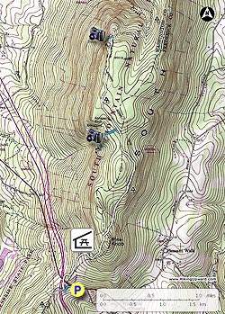
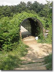
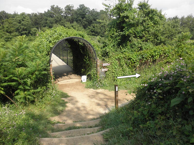
Mile 0.0 – From the parking area on US40 start down the old paved section of the connector trail. Turn left at the blue blazes for the 75yard walk down to the intersection of the Appalachian Trail (A.T.) and pedestrian bridge over I70.
Mile 0.1 – Turn right/north on the white blazed AT as it follow I70 and shortly passes beneath US40. This section of the hike is noisy with the traffic on I70, but shortly after passing beneath US40 the A.T. will turn right and start ascending the South Mountain ridge. At the ridge the trail turns back to the left and the noise of the traffic starts fading into the background.
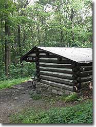
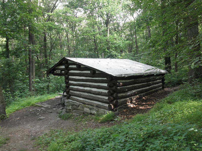
Mile 0.5 – Pass through a utility clear cut and arrive at the 1st connector trail for the Pine Knob Shelter. Along with the shelter there are 2 large campsites suitable for multiple tents. After passing the 1st Pine Knob Cabin connector trail, pass the second in another 200 yards. From this point the A.T. will become significantly steeper for the next 0.5 miles.
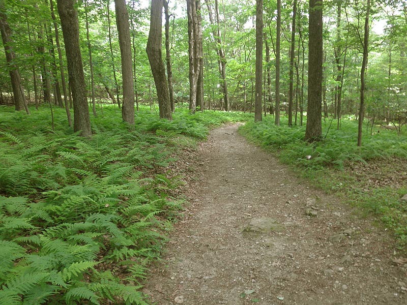
Mile 1.1 – At the ridge the A.T. will pass through several fern areas and reach the intersection of the Annapolis Rock connector trail.
Mile 2.5 – Turn left for the 0.2 mile decent to Annapolis Rock Cliff and camping area.
Mile 2.7 – From the Annapolis Rock Cliff return to the A.T.
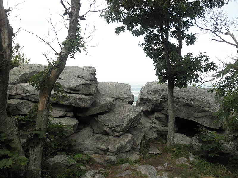
Mile 2.9 – Turn left/north on the A.T. for 1.0 miles to the intersection of the Black Rock Cliff connector trail. The trail sign is not as evident when hiking from the south, but is located just before the A.T. begins a steeper descent.
Mile 3.9 – Follow the the Black Rock Cliff connector trail for 75 yards to the overlook. To return head south retracing your route back to the US40 connector trail.
Mile 7.9 – Arrive back at the US40 parking area.
Mid June
Annapolis Rock
Annapolis Rock/Black Rock Cliff Hike Comments
Archived Comments
By:Hiker
Rating:
Date of Hike: Sunday, September 15, 2019
When we returned to our car after the hike, part of the exterior front door handle and the lock cylinder fell right out into the parking lot when we opened the door. (2016 Honda CRV. We never use key to open the door, so no wear and tear). Dealership said someone had tried to break into the car. Not sure exactly what happened, but beware of this parking lot seeing that other people have warned of break-ins too. (The lot was almost full, so we parked in the part close to Route 40 which is clearly visible from the road).
The hike itself was very nice after getting away from the noise of the highway. Accidentally misread the sign to Annapolis Rock and ended up at Black Rock Cliff. Great view! Another high point was seeing a copperhead on the trail.
By:Peter F
Rating:
Date of Hike: Saturday, August 31, 2019
Wary of Brad's experience, we left nothing visible inside our car and parked amidst 40+ other vehicles. So many taking legal/illegal spots that we waited until a climber exited the trail to take her spot once depated. No damage done to any vehicles before and after trail hiking, 4 hours later.
Trail is well marked and was heavily populated, half of climbers came with a dog. Great vistas from Black Rock and Annapolis Rock. Only saw squirrels and spiders all day.
By:Brad
Rating:
Date of Hike: Saturday, June 1, 2019
Its a great view and the perfect length and intensity for a last minute half day hike. BUT beware of the parking lot. Do not leave any valuables in your car. We and several other folks had windows smashed and bags snatched.
By:Henry
Rating:
Date of Hike: Tuesday, April 30, 2019
This was an incredibly amazing hike! With a group of people, I hiked up to the Annapolis Rocks campsite and was astonished by the view. The campsite was well-maintained and has a fantastic spring with delicious palpable water (though I would recommend filtering it). I camped here for two days and went rock climbing on Annapolis Rock and another one further down called Black Crack. Overall, I would highly recommend it to anybody seeking a hike for a view. However, camping here for a night is ideal, as the sunset is absolutely beautiful over the mountains in the distance!
By:Hiking Family
Rating:
Date of Hike: Saturday, February 16, 2019
Right now the trail is 10% rocks 30% deep mud and 60% ice.
That fact slowed us down quite a bit.
I would imagine this hike would be perfect for a spring summer for my family. Or alone.
Family= 1,3,5,7,36, "29"yr olds
By:Lyn
Rating:
Date of Hike: Sunday, October 22, 2017
This is a very nice hike. You have to walk a little bit to get away from the freeway/noise, but the views and hike itself are nice. A few other comments, for whatever they are worth,,,, We managed to overshoot the Black Rock Cliffs turnoff. There is admittedly a sign - that is quite obvious when you are looking at it - but it's sort of high and easy to miss at eye level. The steep descent down that tells you that you have gone too far, really isn't THAT steep. Also, the start of the hike is a little odd - follow the signs to the trailhead and then you sort of wind down the only path there is for a few hundred yards maybe before you get the AT turn off. Overall, I'd recommend the hike!
By:Susanna
Rating:
Date of Hike: Sunday, July 16, 2017
This was a beautiful (albeit crowded) hike -- not very strenuous at all. There is one "steep" section but it does not last very long. The most of this is a meander and a beautiful one at that (parking was very tricky, however). The one thing of note was that on our way down we came across a rattlesnake (there are signs posted for these and coppherheads) who was crossing the trail. Folks coming towards us were closer and saw it first, the snake did move over to the side but he didn't stay too far off of the trail while resting in the sun so just a heads up, keep your eyes on the trail. Overall, I highly recommend this one!
By:Peter
Rating:
Date of Hike: Friday, June 30, 2017
Holy erosion logs! I hiked this last fall and it was not nearly so bad as this trip. The views from Black Rock cliff are as always, spectacular to the west. But this hike is now a little more difficult than it used to be. I counted the number of erosion logs I had to step over on the way back from black rock cliff. There are (give or take a few) 180 erosion logs in the 2.5 mile stretch between tge exit to Annapolis rocks and the US 40 parking lot. 360 for a round trip, on a relatively flat hike. The tallest brick lighthouse in North America, Cape Hatteras, has 268 total steps, so take that into account when you consider doing this hike. By the way, the count did not include rock barriers. I just thought I would post this because I actually got tired on this hike this time and that's not normal for me.
By:Terri V
Rating:
Date of Hike: Saturday, June 10, 2017
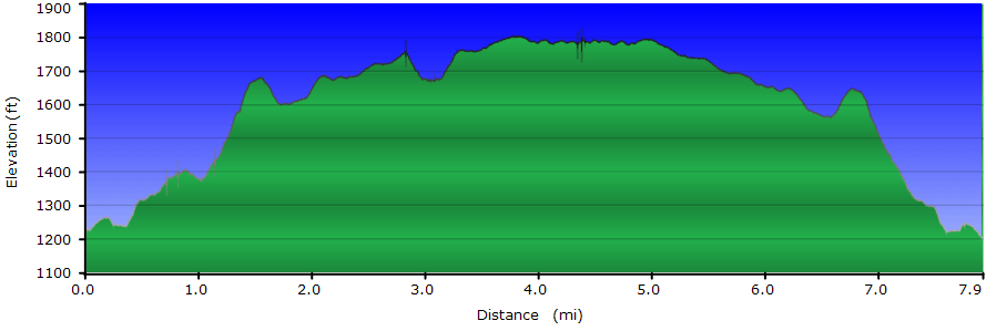
This is a very pleasant hike - not overly strenuous, and some very nice views. I got to the parking lot by 7am on this Saturday, and there were already several cars there. By the time I finished, the parking lot and the shoulder of Route 40 were jam packed. I wanted to get a bit more of a workout, so as I got back near the parking lot, I opted to continue South on the AT, crossing over I-70 and trekking 3.0 miles to Washington Monument State Park. You get a great view if you climb the tower! The final statistics for my hike were 13.4 miles and 2270 ft of elevation gain (per my Ramblr hiking app).
By:Mike
Rating:
Date of Hike: Sunday, February 26, 2017
Veiws at Annapolis Rocks /Black Rock Cliffs are worth the trip alone. Trail is pretty easy hiking and very we'll marked. The trail from parking lot on 40 and along rt 70 is noisy and pretty trampled and trashed-but once you turn uphill and north all is good. Recommend this hike for sure. Get to parking on 40 early, fills up quick.