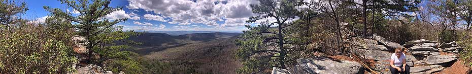
The White Rock Cliff hike, with the spectacular Opa Overlook, is our favorite loop hike in the
Great North Mountain area. This hike has streams, great diversity in flora,
and
sublime solitude. On a clear day you can see all the way to the Shenandoah
National Park from the Opa Overlook.
This area was originally settled by German's in the 1730's, with German and Scots-Irish migrants mainly moving from the Pennsylvania area. The Opa Overlook is also accessible from the Little
Sluice Hike.
Mile 0.3 – Pass the closed gate and continue on the orange blazed FS road for 0.25 miles to the intersection of the pink blazed Old Mail Path
on the right.
Mile 0.8 – In 0.25 miles cross Cove Run and continue following the
pink blazed
Old Mail Path as it turns uphill through short scrub and pine arriving at a wildlife clearing, and the intersection of
the orange blazed Racer Camp Hollow Trail/FS road.
Mile 1.6 – Turn right on the orange blazed Racer Camp Hollow Trail/FS road, pass two more wildlife clearings before the FS road ends, and the Racer Camp Hollow Trail continues into the forest. After entering the forest, the orange blazed trail will gradually descend for 0.4 miles to Racer Camp Hollow Run, and a large campsite.
Mile 2.8 – From the campsite, the trail heads up the valley crossing the run several times before arriving at a hunters campsite in 1.7 miles.
Mile 4.5 – From the hunters campsite continue 200 yards to the intersection of the blue blazed Tuscarora Trail and purple blazed Little Sluice Mountain Trail. Turn left uphill on
the blue blazed trail (the immediate blazes you see are the
green deer study markings). After 1.4 miles
the trail will have crested the ridge then arrives at the white blazed White Rock Cliff Lookout Trail on the right. There is no signage at this intersection, but has several small cairns.
Mile 5.9 – Take the white blazed trail for 0.2 miles
where you will pass a high mountain campsite on the right. Pass the campsite where shortly the trail will climb a steep rock scree. At the top of the scree stay left and continue around the knob to the Opa Lookout. Note: The white blazes on the top of the scree are faded and hard to see. Return to the blue blazed Tuscarora
Trail to continue the hike.
Mile 6.4 – Turn right on the blue blazed trail for 0.5 miles
then arrive at the intersection of the
pink blazed
Old
Mail Path on the left, and the blue blazed Tuscarora Trail turns right.
Mile 6.9 – Turn left on the pink blazed trail for 1.3 miles
as it descends Little Sluice Mountain before arriving back at a clearing and
intersection
of the
orange
blazed Racer Camp Hollow Trail you were at earlier in the hike.
Mile 8.2 – Continue downhill through
the clearing, on the pink blazed trail re-crossing the run
and arriving
back at the yellow blazed forestry service road.
Mile 9.5 – Turn left on the FS road passing the closed gate and upper parking area.
Mile 9.8 – Arrive back at the lower parking area.
Late August
White Rock Cliff - Campsite and Drone Video
View from the Opa Overlook
White Rock Cliff Hike Comments
Archived Comments
By:Zach
Rating:
Date of Hike: Saturday, August 24, 2019
Beautiful views from the top. Hiked in and stayed overnight at one of the campsites right before the path down to the overlook point. Trail conditions were dry, but rocky descents were a bit taxing coming back. Would definitely return and take advantage of the camping right at the overlook, though this time somebody beat us to the punch.
By:Josh
Rating:
Date of Hike: Saturday, August 10, 2019
Really nice hike. The payoff is at the top, which has a couple very nice camp spots. There's one portion of Racer Camp Hollow trail where we missed a crossing over the water, and lost the trail. We continued following the water, but luckily we downloaded the terrain map to our phone to find our exact location and get back on track.
Also, I lost my black water shoes near the higher parking area if anyone comes across them!
By:Sarah
Rating:
Date of Hike: Sunday, October 14, 2018
One of my favorite hikes in the area! Did it as day hike and it took a little under 5hrs, including breaks. No fall colors yet, but it was very peaceful and quiet. We only passed 2 other groups during the whole hike. The trails were a bit muddy due to recent rain, so make sure you're prepared if it's been wet. I have a small car - Nissan Altima- and made it to the top parking area without much of an issue. Just took it slow and careful. Definitely recommend if you're looking for a nice hike with a little bit of everything!
By:Marc
Rating:
Date of Hike: Saturday, September 22, 2018
Some of the early trails are actually small streams (before the recent rain), so be sure to wear boots. I opted for the lower parking area (even with 4x4). Walking up the 0.3 miles made me glad I did, as the road was pretty torn up.
I turned this into an out-and-back hike by taking the Old Mail Path to the Tuscarora Trail. The ascent was pretty rocky and the grade was steep, but the final views were worth it. It took 2 hours out and 1.5 hours back (mostly down-hill!). I train for incline hikes so it was do-able, but I'm not sure this route would be enjoyable for the casual hiker (especially with a pack).
Starting out, I saw a group of hunters walking in ahead of me. By the time I got on the Old Mail Path, they were further down the fire road and I eventually heard them shooting a good distance away. The area currently has a primitive weapon rule in place (bows and muzzleloaders only). The trail markings were decent but you might want to save the map to your phone ahead of time (zero service). Saw a few horses on the trail and some friendly deer. Cool hike, will be doing it again.
By:MJ
Rating:
Date of Hike: Sunday, August 26, 2018
Did this hike solo on Sunday. For the first time in my east coast hiking career, I saw no other humans in the almost 5 hours i was out hiking.
The rating of this hike as moderate is accurate. On the forest roads, you can cruise along through the grass with ease however, portions of the Racer Camp Hollow section are fairly rocky, muddy, and slippery. The ascents and descents are sneaky though and very manageable even though my GPS said I went up around 1600 ft and down the same.
To echo older reviews, the blazes continue to be virtually non-existent, not the right colors, and of zero help. However, it's fairly easy to stay on trail if you bring a map as it's obvious. A few possible exceptions: 1) As you come up the trail portion of Racer Camp Hollow, you'll cross the stream a number of times and on this day, the path was the stream at times. I missed a crossing at one point but as the path petered out pretty quickly, this was easy to recognize and then turn around. 2) at the turn at the end of Racer Camp Hollow, you'll find yourself in two clearings of hunters camps with lots of possible trails to choose from. There are two camps/intersections here. At both, choose the path that's the most on your left. 3) this was purely dumb user error and not checking the map but at the end as you descend Old Mail Path and come to the fire road section of Racer Camp Hollow, make sure you cross the road and clearing and go right back into the woods. Don't happily bounce on down the fire road for 3/4 of a mile. This is obvious on the map, but the trail across the clearing is very obscured this time of year.
On mud, even though it hadn't rained much if at all in the last week, the first section of Old Mail Path and the trail portion of Racer Camp Hollow were wet and muddy. i was glad to be wearing my Gore Tex boots as avoiding wet feet would have otherwise been very tricky. Still, i didnt find this to be super troublesome, especially if you've experienced similar type hikes in the area.
The gnats that attack your mouth, ears, and eyes were relentless. No mosquitos though. Also, so so much spider web across the trail, even with a constant waving of a stick out in front of me.
Critters: no bears, human monsters, deer, ticks, or snakes even though i was on high alert. No bear scat even. I did see chipmunks, squirrels, lots of birds, and a big vulture thrashing his way through the thick canopy.
The leaves were just starting to turn and the variety of fungi everywhere was awesome. It's possible there is a bonanza of chantrelle mushrooms out there right now or maybe it was the poisonous Jack o' lanterns? Someone who knows should have a look. Great tree/plant variety too.
The lookout really is a stunner, especially after spending the rest of the time in dense, silent forest. Also, it was refreshing to not see a single piece of trash, though i didn't have a close look at the fire pits.
One last note about the road in. On the lower, well maintained section, there is a spot that's been washed out. This is still doable with a little car (tho i was in a truck), but that may change with continued precipitation. The upper section of .3 miles is doable with a smaller car as one was up there in the parking area however, i would have been worried about it if that's what i was driving. You'll have to back down if you change your mind on the way up.
By:Heide
Rating:
Date of Hike: Saturday, August 25, 2018
Really nice hike through the woods. The only view was at the very top and it was worth the hike! The rest of the time you are in heavy woods. Quite a few stream crossings and muddy areas due to recent rain. The grade was gentle and this was not a difficult hike.
I would NOT hike here October - December when the whole area is open to hunters. The clearings are all established for taking a deer from a tree stand. They also open the area to vehicles for hunting access. Wear blaze orange if you hike here during hunting season.
By:Zach B
Rating:
Date of Hike: Saturday, July 28, 2018
My partner and I backpacked this hike, spending a night in a great campsite near the overlook. It provided a good challenge with a 35 pound pack. At different points along our hike my group twice encountered a rattlesnake in the middle of the trail, and twice encountered young black bears very close to the trail. The bears were young enough that we feared their mother may have been close by, but we didn't run into any trouble. Make sure your group is making some noise!
By:Babbling Brooke
Rating:
Date of Hike: Wednesday, July 4, 2018
Great hike!
Not sure it needs to be a level 3 hike. For me, its more like a 2. I did the hike in reverse, going from the Pink trail to the Blue trail, then Orange trail, which has the steeper profile. The only difficult part of the hike is the initial climb. The distance is long and elevation gain not that great. Even this part of the trail was simple. It should be even easier if you take the Orange trail first.
There were a lot of streaming crossings. It had rained within the last couple of days I worked my way around many some mud holes at the beginning. The trails is also used by people on horseback. You might have to dodge some horse poop here and there.
Please be careful where you walking. I almost stepped on a timber rattlesnake near one of the stream crossings along the orange trail. Along the Orange trail, not far from the intersection from the Pink trail, there is a lot of tall grass that covers a fire trail. Be careful in the tall grass snakes are hard to see in these areas.
Otherwise, it was a nice hike.
By:Scoutmaster
Rating:
Date of Hike: Saturday, April 21, 2018
Very busy weekend on the trails. A local equine group was having their spring ride (had to dodge many land mines). Passed several other groups of folks backpacking for the weekend. The trail is great. We enjoyed each part, from the lower stream crossings to the ridge and view of the Shenandoah Valley. The weather was perfect, and the large campsite worked out well for our troop of 18 people. Thanks for your review. We printed the trail map directly from your site and used is for navigation. I would be interested in seeing more hike options in this area of the George Washington National Forest.
By:Kilian
Rating:
Date of Hike: Tuesday, February 20, 2018
Did an overnight trip and stayed at the high mountain campsite. Was an incredible day, 76 degrees and no bugs since it was winter! It's a good hike with some nice scenery changes and a few lovely walks along ridge lines. The Opa Overlook is nice if often windy but my personal highlight is the campsite(s) up near the overlook.
It can be a bit muddy but is never too difficult or steep. Probably the best hike in terms of solitude, views, trail within 2 hours of DC.


